GPS and County Highpointing *1,2,3

Custom Search

*1 Original content by Glen Bock

*2 Addendum by Gordon MacLeod

*3   wordsmithed by Adam Helman


What is GPS and how it Functions

GPS is a satellite-based system for determining with great accuracy the position of an earth-based object. Originally developed for the United States military, GPS (Global Positioning System) consists of 24 satellites that continuously transmit timing information. An earth-based receiver may use this data to triangulate its position based upon the simultaneous reception of either 3 or 4 signals from as many satellites. Three signals are sufficient to determine latitude and longitude with high accuracy and precision - while four signals are required for the additional determination of altitude.

In greater detail, the satellites send out time signals and the GPS unit receives these. The time it takes for each satellite's signal to be received is recorded, thus generating a sphere of distance from each satellite. The GPS unit lies at the intersection of these various spheres. A minimum of 3 signals are needed to be "in view", 4 is best, but barring any problems say, in the bottom of a steep valley, the GPS unit is likely to "see" 7-10 GPS spacecraft, so allowing the GPS to select the best geometric set to use in triangulating its location.

The satellite-borne clocks are accurate to one-billionth of a second (light will travel about a foot in that amount of time), and the resulting accuracy of the time signal method (as presently available to civilians) is around 30 feet (pretty good). Many GPS units will also allow "time averaging" of a location allowing greater confidance in a location by taking multiple "readings" of a location AND allowing the constellation of spacecraft to change - so allowing many differing geometries to be involved in solving for the location.

If for example you are 100 feet from a particular fencepost (GPS satellite 1); 200 feet from a large rock (satellite 2); 56 feet from a treestump (satellite 3); and 30 feet from a squirrel (satellite 4), you can determine your positions fairly well.

GPS in the Context of Outdoors Activities

GPS may enhance the experience and record keeping of many outdoor activities. A GPS unit will let you mark, and record a timestamped waypoint of anyplace on the surface of the earth. Record a few, or as many as you wish, of these waypoints and you then have a highly accurate record of any outdoor excursion, including direction traveled, time to travel each and every leg, and even average speed (some devices will record instantaneous speeds as well).

What can be generated is a record of locations that the hiker passes through. The device may be used passively to document a journey by placing it in a backpack and allowing it to record points encountered. Alternatively, GPS may be used actively, allowing the user to load a known location from either a map or location database. In active mode the GPS unit directs, in a rudimentary way, the user from one point to another, in some cases giving distance, bearing (magnetic or true) and even time of arrival at the location at present speed. String many significant "travel points" together and you can generate a route that the device will actively tour you through, telling you where and when, and in what direction to turn. To attain a specific geographic location (aka County Highpoint), it would be good to create a starting list of waypoints of attainable locations enroute to the desired location.

In the case of a highpoint that is a true mountain summit, the attainment of the highest elevation may be obvious to even the most casual observer. However for highpoints with shallow terrain, and little in the way of obvious detail, a GPS unit may provide increased certainty that the attainment of a grey-area highpoint is realized.

Even if later the exact identity of a highpoint is disputed, there will be an accurate record of the location attained, with time and date, and locale recorded to a typical accuracy of tens of feet in latitude and longitude.

Practical Use Of Latitude/Longitude and GPS Technology

In Colorado, many of the county highpoints are easily located, high mountains or obvious summits. The highpointer may record any additional details to a high degree of accuracy (trail intersections, boulders, trees, dangerous areas) and then explicitly and accurately communicate those locations, routes and details in numerical terms. These numbers can then be used by others to enhance their own personal exploration and attainment of these points (or not if the user wants to explore on their own). This allows for greater confidance, situational awareness and knowledge about the geography, topography and trailfinding.

Debates and useful conversation/comunication can only be enhanced by the use this accurate method of presenting locations, times and bearings. Many GPS units support the direct linking of a computer to the onboard memory, allowing the user to actually "save" their trip's waypoints in a format that can be labeled, organized and archived. These saved files can then be shared, much like and along with the trip reports that are so much a part of our hobby.

Imagine going to a highpoint in a state you have never traveled through with the confidence that you can directly locate the EXACT legal parking lot, and travel along a known safe route to a point that someone else has painstakingly mapped, plotted, researched and recorded. If Mallory had such a tool we would know with accuracy his fate and achievements.

Add to this the fact that many county highpointers just plain LOVE maps and mapping - and the interface of computer, GPS and maps is complete: one may a trek up a mountain, attaining the highest point and then return home, link the GPS unit to a computer and thereby generate a map with the exact route you hiked emblazened in red (or whatever color you choose) directly traced onto the USGS topographic map. It would include times of every point along the sojourn.

One may even record exact locations where pictures are taken so bearings, distances and features could be exactly identified after the hike without having to distract one from the true beauty of the trip. Or one can do it all on the trip, accurate triangulation of unattained locations being simple with the recording of two waypoints and their attendant magnetic compass bearings, allowing the fun of the trip to last longer as you review the trip at home.

GPS devices are becoming inexpensive that will allow the input of a target location. In the future these recording devices may become more useful than even the maps used for hiking. In fact one can add wonderful hiking graphics to trip reports - so leaving very little ambiguity to one's achievements. Imagine downloading a map, waypoints (input into the GPS unit via computer) and actual pictures of the hike (linked to the map). It affords a capability of planning and forehand knowledge that Lewis and Clark would find amazing!

"Disputed highpoints" may now be discussed with certainty and exactitude hitherto impossible, conveying to anyone the exact location one is talking about (to a reproducable accuracy of 20 feet).

There is also the safety factor of locating shelters (natural or manmade) that you have never seen. Weather can change quickly, and having the confidence to locate a contingency shelter quickly without getting lost in the adrenalin of the moment may spare individual discomfort and injury, and at the very least make the trip much more enjoyable.

Unique features of very small scale can be located and re-visited by others. For example, GPS technology has spawned a completly new and very complimentary hobby of geocaching wherein "presents" are hidden at unique locations all over the United States for the curious to find, be it with GPS or standard map and compass - so enabling one to explore not only the highest points, but also the places that someone has found beautiful and special.

I recently ferreted out a 10-inch square tupperware container that had been hidden by someone I don't even know (oddly enough the day before) in a place I had never considered going to. Using only a GPS and a wonderful day I was able to locate the container, hidden under a fallen tree and made a log entry. There are literally hundreds of these caches all over the USA, placed by people that want to have fun. I'm sure this skill will have great useful influence on the also developing hobby of county highpointing.

Perhaps soon people will distribute exact routes, turns and switchbacks, elevation gains and bearings for every highpoint. Together we can generate an amazingly useful database that will increase the efficiency, safety and legality of our chosen hobby.

"The more you know about your surroundings, the better you appreciate them and remember them".

Tips and Suggestions

I personally find DD.ddddd format the easiest, but most people are familiar with DD.MM.mmmm and it's the default format of most GPS units.

The DEM elevations are derived using USGS 1:100,000 Digital Elevation Model and are to be taken with a grain of salt, particularly for those locations that the elevation is known well.

You can often get a cigarette lighter power plug allowing the recording of the entire road trip to the trailhead too. TOPO software will even allow the recorded route to be "profiled" or the elevation gain and loss plotted out along the drive/hike. One may determine not only average speed of a hike, but also elevation gains and rates of elevation gain at various parts of the trip. This method is FAR superior to my recording altimeter watch!

An additional use for a GPS recorded waypoint (or the map-read ones included) is that by going to terraserver you can enter in the latitude/longitude and (if they are in the database) see a USGS flyover view of that particular location (1 meter resolution in most cases). I did a hike in the Canyonlands a few years ago and was able to plot the exact hike I did from the recorded waypoints in my GPS I took in the field, AND even located a particular boulder we camped next to (and the nearby arroyo) that I took pictures of on the ground in the USGS flyover. It definitely added a HUGE dimension to the experience: being able to print out the hiked trail in map format AND include a flyover photo in my personal trip report!!

There is a free piece of software that the Geocaching people are using to save and read the waypoints from/to their GPS units and they can then send the waypoint files to each other (or post them on the web) that will work with virtually all computer-interfaced GPS units on the market. It is downloadable for free from the geocaching site.

GPS is a wave of the geographic and location future - it never hurts to know exactly where you are at any given time. I used my GPS to record hikes, and in one case a 12 day canoe trip in the wilds of the Missinaibi River in Canada, I'll be able to convey exact campsites to anyone in the future using the recorded waypoints I made from inside my tent every night before I went to sleep (only used 3/4 the charge in one set of batteries too!)

If more people start doing this, many a hiking-related hobby will be advanced through rapid, accurate dissemination of exact locations, terrain and bearings to features, peaks and trailheads.

It may be as common as having a compass in the coming years. There is also the ability to interface with internet photographic maps, and TOPOZONE, or terraserver maps, as well as with standalone mapping programs like Delorme or my favorite TOPO!

Indeed, with version 3 of the TOPO! software, you can put links directly on the map, click on a waypointed location and up will pop a picture you took (and saved on your computer via digital camera or scanner) of that location. Furthermore the files are sharable! The Colorado set of TOPO maps (7 CD set) is something like only $100 or $200 - which comes to 7 cents a 1:24,000 quad if I remember right. Finally, the upgrades to the software are amazing.

In a few years you'll be able to generate a relief panorama shot from any particular waypoint location looking in any direction and SEE what the surmounding mountains look like using the topographic data. I bet this will be available off the shelf in a few years to the normal user. There are some programs out there already to do it, but they are particularly cumbersome to use, and you need special (expensive) datasets.

This stuff rules!!!

Addendum - GPS Functional Capabilities and Advantages
- by Gordon MacLeod

A remarkable capability for trip planning and field navigation results from the combination of a high-tech GPS with the capability of receiving both downloaded maps and waypoints generated by map computer programs. The maps are complete with roads at all levels of utility (down to four-wheel-drive accessible only), trails, washes, lakes, facilities of all sorts, peak names, and more. I find that my GARMIN GPS III Plus serves admirably for the GPS unit, while DeLorme TurboQuads is a good waypoint-generating program.

This capability has been recognized and, indeed, exploited by the marketing departments of the map developers and GPS manufactures. However I suspect that most GPS-using peak baggers are not taking full advantage of this remarkable capability. We certainly use purchased USGS topos; and either download portions from TopoZone or use TurboQuads (or MapTech's competitive product) for trip planning. However, are we downloading waypoints (or even entire routes) that can be readily created to mark key road or trail junctions, peak locations, etc...?

The accuracy with which those waypoints match their true topographical location is impressive, the waypoints having been created by using map programs and then downloaded. Typically, on a summit with a benchmark, the error between the waypoint benchmark location and that reported by the GPS unit is about 10 to 20 feet - highly accurate. On summits without a benchmark, an extra source of error, of course, is introduced by the uncertainty of identifying the actual high point, so the error between the waypoint location and that reported by the GPS unit increases to about 50 to 100 feet.

These figures contrast with the larger errors of 100 to 300 feet that arise from manually interpolating coordinates from the topo charts themselves, and subsequently downloading said coordinates into the GPS unit.

Note that the aforementioned error between the downloaded waypoint benchmark locations and the GPS-reported actual positions of about 10 to 20 feet compares with the GPS unit's calculated 2-summa horizontal position error of typically 10 to 20 feet.

Note also that this discussion refers to horizontal position error and not the vertical position error, which is -- as you are well aware -- a totally different matter because of the significantly increased errors arising from the relative geometry of the various satellites in earth orbit.

Handheld GPS technology moves ahead with significant improvements in accuracy and in memory capacity since my purchase of a GARMIN GPS III Plus for $400 in 1999. Although I cannot quantify the improvement in accuracy, the memory capacity has increased from 1.44 MB in the GARMIN GPS III Plus to 19 MB in the current top-of the-line GARMIN GPS V Deluxe model for $500. A 1.44 MB memory accepts a download of detailed road information plus data for about five average-size Arizona or Nevada counties. I estimate that the 19 MB memory could accommodate all of Arizona and Nevada at the same time - a noteworthy feat.

Addendum - GPS Functional Capabilities by Example

      - by Gordon MacLeod

Example one: In DeLorme's TopoQuads program, you can select, generate and download a waypoint for a key road junction, such as the point where you plan to leave a gravel road and access a secondary road. As you approach the road junction identified as a waypoint in your high tech GPS receiver, you will see a cursor, representing your vehicle, on your GPS display moving towards the road junction in real time. At the junction itself, you can expect to be within 20 to 50 feet. This account generalizes to all waypoints and applies to four wheel drive road forks, trail junctions etc...; in daylight, at night, in whiteouts - you name it.

Example two: You just took the right fork at a trail junction, but things just don't seem right. You wonder, did I turn at the correct junction? Your GPS unit can determine within minutes your position relative to the waypoint marking the correct junction, under all conditions. Furthermore, the GPS unit determines how far you are off-route and in what direction, guiding you to the waypoint itself.

Example three: You didn't get around to making a waypoint for a key road junction and you are wondering whether that four wheel drive road forking to the right is the one you should take. You were savvy enough, however, to have generated a waypoint for that county high point you're after. The GPS will tell you how far you are away from the high point and its bearing. The bearing by itself is sufficient to locate yourself on the map, provided the high point is on the map. If not, use your compass to determine whether that bearing has you looking at a likely county high point.

This ability of the GPS unit to determine the distance and bearing to a waypoint is profoundly valuable, and undoubtedly one of its most useful contributions to navigation. So, a cardinal rule is: At a minimum, while at home make waypoints for the summits that you plan to climb with a favorite map program. Making waypoints on-the-road is not advisable, as this will embroil you in the details of UTM (or latitude / longitude) coordinates and is error-prone if you are not mathematically inclined.

Example four: Is it not satisfying to know that you are within 10 to 20 feet of the county high point you were seeking when sitting on the presumed high point eating your lunch?

Example five: If you have the GPS unit "on" while driving, it automatically generates a trail of electronic bread crumbs that mark your route. If you are uncertain of which forks you took, or if you are in a whiteout, simply reverse course by following the bread crumbs. Neat, don't you think?

Appendix - GPS Rules

The GPS spacecraft constellation cost american taxpayers around 14 billion dollars. Once you buy a GPS unit you can use the system as much as you want. No access fees or other charges (except for say batteries).

The GPS system can be augmented (for civilian users) to a greater accuracy by using differential GPS, allowing accuracies of a few inches. Military devices allow centimeter accuracy all the time with no additional equipment, and use an encrypted access system to allow Milspec GPS devices that "fell into the wrong hands" to be rendered virtually useless. As of 2001 the military has never severed civilian access to the constellation (but they could given a significant need). However nowadays so many devices depend on the system, it would have to be a serious situation for that to happen.

Appendix - Specification and Use of Datum

      - by Adam Helman

It is imperative that the same datum be employed in the GPS unit and the corresponding topographic chart. For the continental United States the main choices are the NAD27 datum and the NAD83/WGS84 datum. Failure to recognize this will often result in position errors of up to 300 meters as shown in Figure 1. In that figure, the absolute differences between NAD27 and WGS84 coordinates are presented on a 5 degree grid superimposed on the lower 48 United States. Note how the West Coast suffers the largest magnitude differences.

GPS datum error
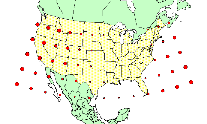
Figure 1. The absolute difference in NAD27 and
WGS84 coordinates presented as circles of varying radii.


back to general map page