Mariposa County Highpoint Trip Report

Parsons Peak Ridge by a cross-country route from Mount Lyell base camp

Date: August 19, 2001
Author: Adam Helman

Note - this is a new route that efficiently combines visiting the highpoints of Tuolumne (Mt Lyell) and Mariposa (Parsons Peak Ridge) counties in one trip. When it is desired to visit just the Mariposa County highpoint (hereafter M-cohp) on a given trip the route described here is not relevant, as the route begins and ends at base camp for climbing Mt Lyell. For just Mariposa County, please refer to Gary Suttle's book on climbing the California County Highpoints for information on the standard approach to this highpoint via Ireland Lake, as well as the other trip reports for Mariposa County.

Coby King provides a *.tpo waypoint file for this route as closely approximated by his cross-country effort on July 12, 2008.

All photographs linked to are provided by Kurt Mitchler when he led a Boy Scout troup on this route the following summer.

After a successful summit of Mt Lyell with Edward Earl and Kurt Mitchler on the previous day, I decided to visit the M-cohp via an efficient cross-country route that would obviate the following effort as suggested by standard protocol (cf Suttle's book etc...): descending six miles down the valley; re-ascending the opposite trail fork with full pack six additional miles to Ireland Lake (1,700 vertical feet); and climbing Parsons Peak with the M-cohp as a liner along its northwest ridge.

Although I awoke to a hacking cough and fever, I was determined to make a good faith effort seeing as it would be a pity to lose this opportunity for extending my home glob radius to 380 statute miles.

Small unreadable cross-country map.

The following route description requires examination of the
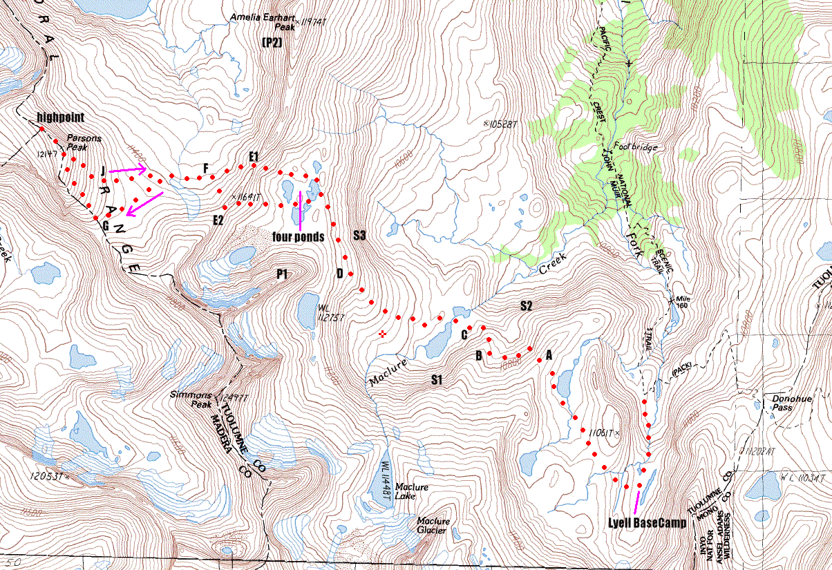
annotated map available by clicking the image at left.
The resulting 305 kB GIF-formatted topographic map will take
some time to download if you are reading this via the Internet
and you do not have a high-speed connection. Red dots indicate
the route with roughly 400 feet between dots serving as a scale.

The route begins and ends at the area indicated by "Lyell Base Camp" in the map's southeast quarter. There are adequate lakes and streams at this 10,800 ft elevation for establishing a base camp to climb Mt Lyell on either the previous or succeeding day. As noted above, this route makes no sense unless you are climbing Mt Lyell on the same trip!!

Hike west or northwest into the 11,000 ft grassy area that lies immediately north of the granite slabs that one climbs to access the lower portion of the Lyell glacier. Rather than heading up these slabs (as one would do for climbing Mt Lyell), contour clockwise around the 11,061 ft hill while remaing at the level of the first lake immediately to the northwest of the hill. Head for the ridge indicated by "A" in the map and climb the class 2 boulders to the ridgetop.

At the ridge you will enjoy a panorama of the basin beneath you and to the north. Note the steep sections indicated by "S1" to the west and by "S2" to the north. You want to avoid S2 by remaining high as you climb up and down jumbo slabs to the west either along the ridge, or to the north side and immediately (50 vertical feet) below the ridge.

After several hundred feet you arrive at point "B". Here you descend along a stand of trees some 200 vertical feet - heading in the general direction of the lake indicated by "C". This maneuver avoids steep section S1. After this short descent you will find that you cannot continue in a straight line directly to the stream outlet of the indicated lake: it is too steep. Rather, ascend a hill immediately in front of you so as to descend the hill's north ridge as it leads comfortably to the flat area immediately west of the lake's stream drainage.

From the lake area ("C") your next goal is a group of "four ponds" located immediately under the conspicuous ridge that connects Amelia Earhart Peak ("P2") on the north with Simmons Peak on the south. You cannot see these little lakes until you are right upon them. However you may have been tantalized by their beautiful green color when you were atop Mt Lyell the previous day.

Note steep section "S3" and the prominent mesa "P1" in front of you. You can avoid S3 by hiking up the obvious wide ramp of granite slabs, passing immediately underneath and to the east of P1, in a generally north-by-northwesterly direction. This section is indicated by "D" on the map.

At the four ponds one may investigate routes for crossing the critical pass at the point of your choosing. Two obvious options are indicated on the map by "E1" and "E2". Do not be daunted by the visual evidence: although no one route appears less steep than any other, as you approach the pass along your chosen path, you will find that the terrain is not as steep as it appeared from the ponds. The gradient seemingly "melts away" as you approach.

At the ridge (E1 or E2, for instance), one obtains a view for the first time of the main objective - Parsons Peak and its northwest ridge leading to the M-cohp. One also sees Ireland Lake as a large sheet of blue perhaps a mile to the northwest.

At this juncture one may be tempted to remain high and contour around to the southeast base of Parsons Peak. I do not recommend that - advocating instead a descent some 200 vertical feet to the basin at point "F". One then walks on gentle slopes to the west-by-southwest, aiming for some point "G" of your choice on the southeast ridge of Parsons Peak.

Ascend the southeast slope to the summit (12,147 ft) and examine a beautiful, large cairn. The actual M-cohp ("highpoint" on the map) is located some 100 vertical feet lower than the summit, some 800 horizontal feet along the obvious ridge running northwest therefrom.

It was very windy when I was there, and I decided to keep a respectable distance from the steeper northern side of the ridge: the wind was strong enough for me to lose my balance.

After lunch and the requisite breathtaking views one may elect to descend more steeply as indicated by "J" in the map, heading all the while for the point "F" beneath the pass. I managed to descend from the pass to "F", and re-ascend on that side as well, by climbing inside a prominent gully for some 2/3 of the vertical distance.

From the pass (E1, E2) one returns via the route of ascent. The entire route is class 2 if you have navigated correctly (there may be very short sections of "marginal class 3" on the jumbo granite slabs in-between points "A" and "B").

The net vertical gain for this route is some 1,350 feet. The gross vertical gain, i.e. accounting for some 500 feet lost in each direction plus regaining the true summit after visiting the M-cohp, is some 2,400 feet.

It makes less sense to use this route as a means of climbing Mt Lyell from a base camp originally set up at Ireland Lake for climbing Parsons Peak: this would introduce an asymmetry in the duration of the two climbing days with Parsons Peak requiring but a few hours while Mt Lyell would consume over 12 hours since the 11,000 ft high grassy area under the Lyell glacier, as the highest point of common ground for climbing Mt Lyell and this cross-country route, is not reached for perhaps 4-5 hours starting from Ireland Lake. In contrast this area is approached after only 15 minutes of hiking from the Lyell base camp indicated.

Stated differently, for a trip combining Mariposa and Tuolumne County highpoints, one proceeds up the trail fork leading to the suggested Lyell base camp. At that point it may be preferable to climb Mt Lyell first (as we did), so as to obtain views of the following day's cross-country route from on high. Indeed, much of the described route was visually confirmed by Edward Earl and myself while atop Mt Lyell the previous day.

I consumed some 8 3/4 hours round trip for this cross-country route. I estimate that normally the route would require 6 or 7 hours plus summit siesta. The difference is accounted for by several factors -

I suspect that during the winter months the preferred route would be similar. Furthermore if one were to go earlier in the climbing season it would be advisable to take ice axe and crampons for the occasional patches of hard snow and ice - particularly on the north side of Amelia Earhart Pass (E1, E2).

Addendum: The combination of Tuolumne and Mariposa Counties will likely be the last trip I undertake from San Diego by automobile in order to extend my home glob radius. With the latter soon at 400 miles or thereabouts, future county-claiming efforts will be exclusively by airplane and rented vehicle (as most have been until now anyways!)

Trip statistics: