Mono County Highpoint Trip Report

White Mountain Peak (14,246 feet)

Date: September 24, 2005
Author: Adam Helman

Note 1: All NAD27 UTM coordinates are in zone 11S.

Note 2: The sections "Preparations and Problems" and "Rendevous"
              may be skipped as they are only of personal interest.

Overview

White Mountain Peak is the White Mountain Range highpoint - loftiest summit of the entire Basin and Range geologic province extending from California'a Sierra Nevada to the Wasatch Range in Utah. Indeed at 14,246 feet, White Mountain Peak (henceforth "WHMTN" for brevity) is the highest mountain in-between the Sierra Nevada and Colorado Rockies.

WHMTN boasts several additional superlatives -

I had climbed WHMTN with a friend at work several years earlier. In his twenties, Pony Samuth performed quite well at high altitude - and, after a 7.5 hour round-trip effort, we returned all the way to San Diego that very evening.

My brother Dale wanted to climb WHMTN for a few years, having learned of the excellent summit views from myself and other sources. His wife's brother Spencer wished to participate. I offered to "take them up" WHMTN this weekend provided they follow an acclimatization regimen that included two nights at altitude prior to ascent. Thursday night was spent at 9,000 feet in Tuolumne Meadows as they drove east on Route 120 over Tioga Pass from the Monterey/Salinas area. Friday night was spent near the trailhead for WHMTN at 11,700 feet. The ascent followed on Saturday.

Approach

From the north end of Big Pine turn east from Highway 395 onto Route 168. The road is sinuous as it rapidly gains elevation into the White Mountains. After about one dozen miles follow a sign left (north) to the Ancient Bristlecone Pine Forest and White Mountain Road.

The Grandview Flats Campground, at 8,600 feet, is a nice overnight option located a few miles up White Mountain Road. The Schulman Grove, and main Visitor Center, is located perhaps a dozen miles beyond the Route 168 turnoff. The road becomes gravel after Schulman, with much annoying washboard for a good fraction of its length.

Twelve road miles past the Schulman Grove turnoff is the Patriarch Grove at 11,300 feet. Dale and Spencer waited at the turnoff to this grove as I approached at 3:15 p.m. Having left Big Pine at 1:55 p.m. my drive consumed 1 hour 20 minutes - your time will vary depending on vehicle type and driver mindset. I had departed San Diego at 8 a.m.

Dale presented me with a book on climbing California's mountains. The sixty-nine peaks presented are a subjectively derived list from the author based on various aesthetic and practical principles. I have since reviewed the book, while at home, and am pleased to have earmarked several High Sierra peaks as future efforts - including Mount Williamson.

We then caravaned the remaining four miles to the locked gate - trailhead for WHTMN the following morning. The road condition is slighly worse for these final four miles compared with the twelve mile section between groves. A gauge of the road condition is afforded by the 15-20 minutes taken to drive the final four miles - in a high clearance Tacoma truck.

Dirt road mileage is sixteen, and total mileage from Big Pine is either 35 or 38 miles depending on which of my brain cells correctly recorded this tidbit.

I obtained GPS-derived UTM coordinates (390906 E, 4157273 N) at 11,707 feet for my vehicle located perhaps fifty yards south of the locked gate.

Preparations and Problems

It was cold and windy upon arrival - and we donned parkas despite the afternoon hour.

I realized that Dale would come unequipped for camping under these conditions since he does not normally go into the backcountry. In contrast Spencer had some hiking interests - and yet he too did not come prepared to camp in the upper twenties.

Dale and Spencer
Dale (at photo right) and Spencer lie in or
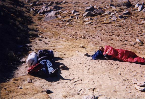
on their sleeping bags before erecting a tent.
I had to prepare and feed them supper since they only had brought trail food for the following day. I also had to erect a tent as they had brought none for themselves. Dale and Spencer's tent was located in a depression immediately southeast of the locked gate - sheltered from the wind and an excellent location to sleep given the conditions.

They had not even brought eating utensils. Fortunately I had a set of plastic spoons, forks, and knives in my red duffle bag.

Since Dale was hungry on arrival, I immediately provided an appetizer session with corn tortillas, black bean dip, Velveeta cheddar cheese, and kosher bologna. Two hours later we ate supper prior to sunset - a communal pot of macaroni and cheese that was both inviting and delicious. I provided mix-ins to the otherwise plain dish. Dale and Spencer enjoyed adding vegetarian bacos. I added black bean dip and (!) tabasco sauce.

That afternoon I gave Dale several gifts - including a pair of Torrey pine cones from San Diego; and three "singing" stuffed birds acquired at the Forest Service office near the base of the Mount Evans Highway in Colorado. The birds, including an owl, pigeon, and red-tailed hawk, "sing" when squeezed on their bellies. Cute. Later I heard birds singing from their tent in the middle of the night.

At 1:41 a.m. I awoke from my slumber to the noise of Dale's car motor in idle. Rather than simply use earplugs, I invesigated the cause of this unseemly activity. Reluctantly I left the relative comfort of my truck's camper shell to learn that Dale had a severe, throbbing headache that was partially relieved by sitting up (as in a driver's seat) rather than lying down (as in a tent).

Immediately I thought: altitude sickness. How much water had he drunk? Did he get enough to eat? Dale drunk copious quantities of root beer around suppertime - and was seen enjoying more as I talked to him through the partly open left window.

I sat in the passenger seat and kept Dale company. We listened to KNX in Los Angeles about how hurricane Rita was just then making landfall on the east Texas coast. We shared some swiss cheese and peanut butter Tiger's Milk Bar sports/energy food. Still with a headache Dale went back to sleep - as did I - although I did not sleep soundly for the remainder of the night.

I arose at 5:30 a.m. to prepare breakfast for Dale and Spencer. Since they had no cereal bowls I fashioned them from both an emptied tupperware container (that had contained unshelled peanuts and cashews); and an emptied gallon water jug that I sawed in half with a chef's knife brought to slice thick rye bread.

As they happily ate Captain Crunch cereal in the heated cab of their Jeep Wrangler I stood outside with a bowl of Frosted Flakes. A bag of dried blueberries enhanced the cereal's flavor (and nutritional value) greatly.

The temperature was below freezing, with dawn colors marking the eastern sky well before sunrise. Fortunately the previous afternoon's wind was absent.

I convinced Dale that he should at least start uptrail despite the headache. I knew that ascent with pre-existing altitude illness was absolutely contraindicated - and yet I wanted to see Dale make some effort for having taken off a day of work and driven several hours to the White Mountains.

Dale agreed to this plan, and we left the trucks at 6:47 a.m. as the sun finally appeared.

Climb

I used an overnight backpack so as to carry a sleeping bag and self-heating meal in case of emergency - cheese ravioli. Normally I would not take such precautions for a day hike. However I was not confident in Dale's abilities, and feared a twisted ankle that would force a bivouac in 20° F overnight temperatures.

After just five minutes Dale claimed his headache worsened. Slowing down the pace was insufficient. We stopped and agreed that Dale return, waiting for Spencer and myself, in turn, at the Schulman Grove Visitor Center and then, later, at the White Mountain National Forest kiosk located at the southeast corner of Highways 168 and 395.

I swapped overnight pack for my usual red daypack, which Dale had carried, and exchanged their contents as well - except for the sleeping bag and cheese ravioli dinner that I no longer felt compelled to carry along. Dale walked down the road with my overnight pack in his right arm instead of wearing it on his back - to me a demonstration of his disdain for doing things the right and accepted way when on an outdoors adventure.

The route is completely on road or trail. After two road miles encounter the Barcroft High Altitude Physiology Laboratory - a ramshackle assemblage of quonset-framed metal buildings and associated equipment.

observatory
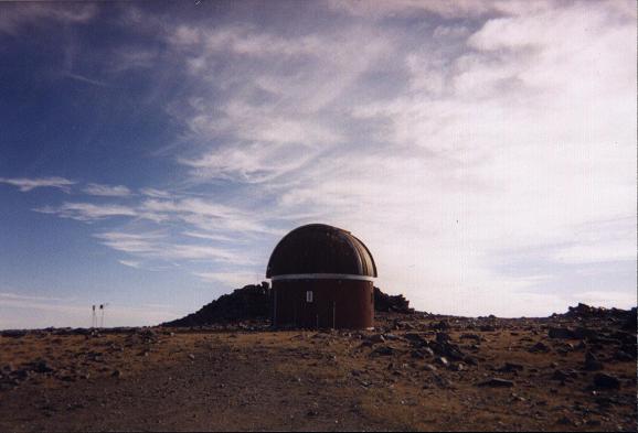
This observatory is encountered
2.5 miles into the hike at 12,850 feet.
Note the observatory dome to your north and one-half mile distant by either of two routes - your immediate goal. One route climbs steeply to the north-northwest from the Laboratory area, and peters out prior to gaining the observatory. The other route is a continuation of the dirt road. Follow the road as it curves northeast around the south edge of the laboratory. After perhaps 0.1 mile the road switches back to the northwest and heads more steeply to the 12,750 foot high observatory.

The observatory area affords your first close-up view of WHMTN. Note the darker rocks extending from 13,000 feet halfway to the summit - and the lighter, reddish rock thereafter. The trail plies almost due north, gaining elevation slowly to a 13,100 foot ridgetop before turning west and dropping to an obvious 13,000 foot saddle immediately right (southeast) of the peak.

The entire route from observatory to saddle is exposed to winds coming up from the Owens Valley - winds that become strong from solar daytime heating of the valley floor. I wore my parka for nearly the entire time. Gloves were not put away until 2:45 p.m. on my return from the summit. Perhaps in high summer the morning temperatures are more pleasant.

The route steepens after the 13,000 foot saddle as the four-wheel drive route zigzags up the southeast slopes of WHMTN. We cached water at the saddle with GPS-derived UTM coordinates (390551 E, 4164782 N), elevation 12,977 feet.

Spencer warned me that he was going to travel slowly, possibly taking until noon for this final summit push. It was just before 10 a.m. Unable to keep my hands warm at Spencer's pace I notified him that I would, finally, walk at my own pace and yet meet him at the summit.

I found that the road switchbacks were annoyingly circuitous, adding excessive mileage with little elevation gain. Thereby I struck out straight upslope for the top - one that was easily identified by a concrete summit structure.

I need two nights at altitude to perform reasonably well above 14,000 feet. Indeed, I had originally toyed with the idea of sleeping one night in the San Bernardino Range, near Onyx Summit (about 8,500 feet), in order to secure two nights before the ascent. I weighed the inconvenience of sleeping a second night in the woods, instead of at home, against the poor climbing performance that would result from acclimatizing over a single night.

I chose to suffer through the poor performance rather than spend the extra night. And so, true to expectation, I was feeling much shortness of breath as I climbed the final several hundred feet to WHMTN's summit area. It took me about 1 hour 15 minutes to "summit" from the 13,000 foot saddle - arriving at 11:08 a.m.

White Mountain Peak
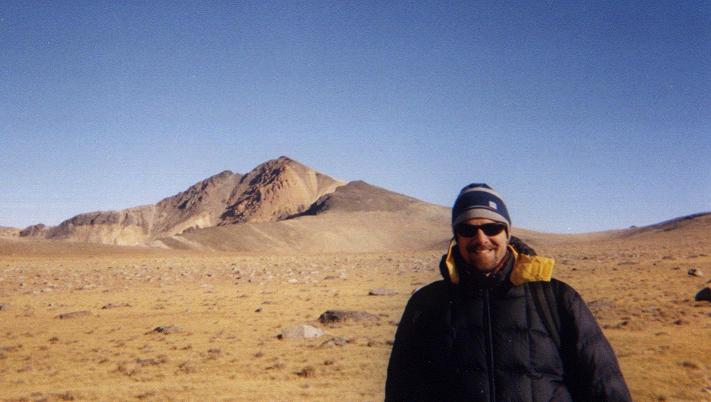
White Mountain Peak as seen from the trail
with Spencer in the foreground.
I had the summit all to myself for 1 hour 15 minutes. During that time I enjoyed kosher pastrami on onion bagel with sliced onion; and took a nap in the circular windbreak with my daypack as pillow. Views of the Sierra Nevada were, of course, spectacular.

I obtained GPS-derived UTM coordinates (389285 E, 4165752 N), elevation 14,235 feet - the official summit elevation of 14,246 feet lying within the error margin for the GPS unit.

Spencer arrived at 12:23 p.m. - having taken 2 1/2 hours from the saddle. We shook hands and celebrated with a pair of sparkling apple cider beverages. More hikers came shortly - one pair discussing their planned winter ascent come January or February.

We left at 12:57 p.m., so making for a very lengthy 1 hour 49 minute summit siesta for myself - one of the longest in my experience.

We went straight downslope instead of taking the road, arriving at the saddle after just 33 minutes and constituting an excellent rate of descent.

The remainder of the climb was uneventful. For the last 3-4 miles I was suffering from a combination of boredom and desire to "get this overwith" from a sense of sheer fatigue exacerbated by having received one-half night's sleep and insufficient acclimatization.

Car-to-car the ascent consumed nine hours - including a nearly two hour summit break.

Rendevous

With reluctance I drove the dirt approach road, Spencer as passenger. Dale's vehicle was not in the Schulman Grove parking lot. Thereby we continued to Big Pine where he was studying Latin in the car. Dale teaches himself many difficult subjects in his spare time. I only wish he would apply that same tenacity to hiking and climbing.

Dale treated me to a restaurant of my liking. Recalling a road sign from the previous day's drive, I suggested the Imperial Garden Chinese restaurant in Bishop some fifteen miles north.

That meal was my favorite time of the entire weekend. We ordered the Dynasty Special that features n main dishes to be shared among n participants for about $18 a person. Soup and assorted appetizers were first served. Then, Dale's choice of hot and spicy beef was tastier than both the crispy duck (Spencer's choice) and the salty fried squid (my choice). I ate heartily - it was irresistably good - having even commented earlier to Spencer that I was craving Chinese cuisine.

Dale re-imbursed me the $100 for gasoline it cost me to drive the 700+ miles for his sake. Do recall that I had already climbed WHMTN. I am greatly appreciative of this gesture.

Dale and Spencer headed north for a motel near Tuolumne Meadows that had peaked their interest on the inbound drive. I drove south to sleep in a parking lot immediately next to the Forest Service kiosk described previously at the north end of Big Pine - arriving well past sunset.

Upon awakening I saw a "no overnight camping" sign within twenty feet of my truck. Alarmed, I drove off in a big hurry - unfortunately with an open container of urine sloshing around in the camper shell that I had intended to dump out before driving. As a result, much "damage control" was performed at the Big Pine Mobil gasoline station, drying off items, including food containers, that had become soiled through my oversight.

The drive home was uneventful, arriving as anticipated 5 1/2 hours after leaving Big Pine. Some 330 Adam truck miles separate Del Mar from Big Pine - and the total journey consumed 765.4 such miles - miles defined by my vehicle's odometer reading and roughly one-sixtieth greater than a (normal) statute mile.

Summary

I love my brother and really really want to see him succeed with the goal of climbing White Mountain Peak. Thereby I am willing to reattempt WHMTN with Dale on a future date. I know Dale is capable of this feat since he succeeded in climbing Kilimanjaro back in 1996 - a mountain fully one vertical mile higher still!

Unfortunately Dale's altitude illness may suggest that he did not acclimatize long enough. As a neurologist with three private clinics, spare time is the resource Dale enjoys least.