Riverside County Highpoint Trip Report

San Jacinto Peak (10,839 feet)

"Mount San Jacinto - The Hard Way"

Date: August 4, 2003
Author: Don Nelsen

Note: A few additional photographs are available from the Riverside County Photographs Page.

I first saw Mount San Jacinto from a flight into Palm Springs back in 1988 and was amazed at this incredible arctic island situated in one of the hottest deserts in the world. I had no idea at the time that I'd ever get the chance to climb and explore it, much less to take myself to my physical limit in the process.

My first chance to set foot on the mountain came in May of '02. The several summit area valleys are covered in Manzanita and old-growth Ponderosa and Jeffery pines. It's a stunning contrast to the 110 degree desert just a few miles below.

This first time up I summited the "easy" way, taking the aerial tram up from Palm Springs to the 8,500 foot level and hiking the 5-mile trail to the summit. I went up a couple of more times, once via tram and once, almost making the summit from Idyllwild on the mountain's west side. (I ran out of daylight - my most common problem since I often tackle climbs after working a full day or nearly so).

Then I heard of "The Cactus-to-Clouds Trail". Now, there are not a lot of 10,000-foot mountains that can be scaled in their entirety, from their roots to their summits. There are precious few, too, that not only can be done in a day and have a semblance of trail to do it on to boot.

Even fewer have such great access: Major hotels a few blocks from the trailhead; a major airport a few miles away. Then there's that convenient tram, relieving one of the quad-killing 8,000 foot final descent!

warning
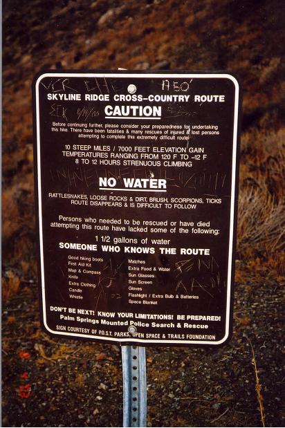
Self explanatory warning.
On August 4, 2003 I found my opportunity to take the trail up and planned to use the tram for descent to the desert floor at day's end - so sparing myself that last 8,000 vertical feet and 10 miles distance in the late afternoon summer desert heat. The forecast that day was for an afternoon high of 107 degrees - about normal for Palm Springs in early August. I have experience running/hiking at these temperatures so I know what it feels like and, in a nutshell, I do not recommending it.

I got an early start (5:30 AM) and the sun didn't come over the mountains on the far side of the valley and hit me until 6:10. It was about 80 degrees at that pre-dawn hour but very dry and believe it or not, more or less comfortable even at my first-hour starting pace of 2,500 vertical feet.

By 8 o'clock, with the sun beating down relentlessly, it felt like about 100 degrees with the waves of heat rising off the cliffs along the trail. I was pleased to find the trail very easy to follow and because a thunderstorm a few days before had washed the loose dust off, the footing on the trail was excellent. Mine were the first footprints on the trail above the warning sign painted on the rock at the 2.3 miles mark since the rain.

I took mostly Gatorade for fluids but also about 6 pints of water in one of those grocery store gallon plastic jugs and a couple of apples - bare minimum, but who wants to carry extra weight!? I made the rim of Long Valley at the ten-mile mark in just over 5 hours and was surprised that there were no other hikers on the trails below the tram station - in fact, I couldn't spot anyone at all!

I made my way up the path to the tram station and found that the tram was closed for emergency maintenance! This was a big surprise since summer is the busiest season for the tram, used both by hikers as well as people seeking relief from the searing heat below so I hadn't planned on it being shut down.

I could see a maintenance worker using a carpet cleaner on the second floor and had to climb the downspout on the side of the tram station to get to where I could get his attention. He let me in and there I found a couple of other hikers he had let in who had come up Friday and were also caught off guard by the unscheduled shut-down and were waiting it out. They were playing cards and watching the TV in the bar and waiting for the one (maybe!) run of the tram that day to take the janitor down at "about six".

The janitor graciously offered me use of the facilities and even the soda fountain - room temperature and flat though it was! I chatted with the guys in the bar while I rehydrated, filled my three 20-ounce Gatorade bottles then departed for the summit.

Palm Springs
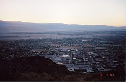
Low elevation view of Palm Springs
by early light.
In some respects, the whole event was a real treat since I virtually had the whole mountain to myself. I met only one other lone hiker and a young couple with a small child who were camping in Round Valley. The views from the summit are exceptional: The ancient pines, Manzanita, and white granite contrast and compliment one another to make the area a photographers delight.

Mounts San Antonio and San Gorgonio rise out of the LA haze even on smoggy days and on this clear day were strikingly impressive. To the southast the below sea level surface of the Salton Sea was even visible, 11,000 vertical feet below, receding into the distance toward Mexico. The north face of San Jacinto descends precipitously over 9,800 feet to the deathly hot windmill-studded desert east of Banning and is an awe-inspiring sight.

The tram station is on a ridge a couple hundred vertical feet above the Long Valley floor and coming back down I was starting to feel the effects of the trek so that was a tough couple hundred vertical feet to re-climb. Anyway, I made it back up there about 2:30 and took advantage of the soda fountain once more and chatted with the same two guys in the bar for an hour and a half and drank about a gallon of flat soda - (not complaining here-anything wet was welcome!)

There was some question as to whether that "about six o'clock" tram was going to run and if it did not, waiting until six would not give me enough time to get back down the trail before dark. Having already come over 20 miles and climbed 11,000 vertical feet I was a bit rubber-legged but I felt I could do it if I paced myself, had enough fluids in me, and didn't melt when I got to the desert heat. I swilled down a few more gulps of soda and hiked over to the rim of the valley and psyched myself up for what I hoped wouldn't be my untimely demise!

graffito
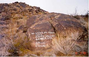
Rock graffito with an important reminder.
I'd covered this kind of distance in a day; I'd run in this kind of heat; I'd even climbed over 10,000 vertical feet in a day - but to combine this into one event - well, that was a bit worrysome! I waited until what I calculated was the last possible moment to start back down, timing it so I'd get to the bottom at dusk, hoping the heat would be bearable on the lower few miles of trail. The first couple of miles down were really the easiest - the trail was softer and mostly covered in pine and fir needles, plus there were fewer rocks to have to jump over. The rest was more difficult with sharp turns and innumerable rocks. At an average grade of 800 vertical feet per mile, you really can't safely run a trail like this, so I was reduced to a slow jog or a fast hike - too many chances to miss-step and then I'd be in trouble. I entertained myself counting switchbacks and lost track at about 250! I think the total is in the 300-range so now I have an excuse to go back and count them to be sure. By the time I reached the hottest lower sections the sun was behind the mountain so it wasn't too bad.

I'd hate to do it on a really hot day! Palm Springs has hit an honest-to-god 125° F in the shade so the heat there can truly be deadly. The only real discomfort was that the bottoms of my feet got blistering hot from a ground surface that stayed almost too hot to touch even after the sun was behind the hills. I had to slow from an easy jog to a walk for the last two or three miles - by then that was about all I had the energy for anyway.

Palm Springs
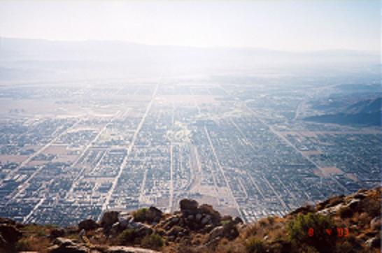
High elevation view of Palm Springs
near the aerial tramway's upper terminus.
The paper said it was officially 109 degrees that Monday but I'd say it was barely over 100 when I got to the bottom just after 7 pm.

For the record, I carried my GPS and the main trail from the desert museum trailhead to the valley rim is 10 miles exactly. (I took the museum trailhead because I stayed at the Holiday Inn - just a few short blocks to the trail.) I think the Ramon Road route will prove to be about the same or slightly longer. The GPS unit counts all those little switchbacks as well as the several dips in the trail so this baby has even more distance and elevation than some accounts relate: The round trip, counting the two trips up to the tram station totaled 30.4 miles and the few extra dips and rises in the trail gives a round-trip total of 11,239 vertical feet.

I lounged at the motel pool most of the next day - rare for me - but quite content to sip lemonade and do nothing at all!