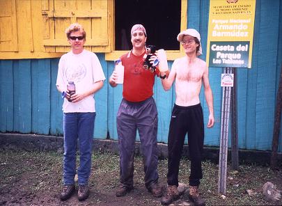
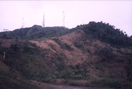
at the Los Tablones hut some four kilometers
into the climb of Pico Duarte.
Concept
By far the most important goal of this journey was to summit Pico Duarte - the Caribbean basin highpoint at 3,098 meters (10,164 feet). As the highest ground in the Dominican Republic and on the island of Hispaniola, Pico Duarte has a prominence equal to its elevation - so drawing all serious participants.
Additional goals included climbing the highest mountain in Puerto Rico; climbing other large prominence peaks in the Dominican Republic; and visiting the Arecibo radio telescope, the largest on earth, in Puerto Rico.
My brother Dale joined Bob Packard, Edward Earl, and myself in New York City for the outbound flight. Since Pico Duarte has a trail to the summit, Dale and I felt that climbing it fell within the limits of his experience level.
Planning this journey was complicated due to different vacation schedules of all four participants. Dale would return immediately after descent of Pico Duarte; Edward a day later; while Bob and I would complete the entire journey - including the side trip to Puerto Rico.
The "other large prominence peaks" referred to above were specifically the two mountains in the Dominican Republic that are ultra prominences, i.e. those exceeding 1,500 meters (4,921 feet) in prominence - Loma Alto de La Bandera and Loma Gajo en Medio. Unlike Pico Duarte, these summits are neither publicized nor generally available to the public without either considerable paperwork (Loma Alto de La Bandera) or local research (Loma Gajo en Medio).
An ascent of the Haitian highpoint, Chaine de La Selle, was considered too risky from a political standpoint. This is unfortunate since it is the second highest and second most prominent peak on Hispaniola.
In constrast, reaching the top of Puerto Rico is quite simple - involving a mere 2/3 mile walk up an asphalt road (Cerro de Punta, 4,389 feet).
We were not in the least interested in the standard tourist destinations for either island. Laying on the beachfront property of some resort hotel neither excites or challenges us.
Description
Tuesday, January 18
The four of us converged on John F. Kennedy International Airport (henceforth "JFK") after a set of three overnight flights from our respective cities - Bob Packard from Phoenix, Edward and myself from San Diego, and Dale from San Francisco. Given that all flights were on different airlines, there was no guarantee that we would all make the critical connecting flight that morning to Santo Domingo.
Wednesday, January 19
A chilly eleven degrees Fahrenheit at JFK. We all met, and then flew in the morning to Santo Domingo, arriving at 11:45 a.m. Upon arrival Bob and Dale's luggage were missing - they had taken airlines other than American Airlines - and, after passing through customs, waited until a second flight from New York City arrived with their luggage at 3:15 p.m.
We took a van to Jarabacoa, the nearest community of consequence for climbing Pico Duarte via the La Ciénaga route - one of five that lead to the summit from various directions. The driver, although skilled, drove far too quickly for safety. He whizzed in front of other vehicles with complete abandon, so making for the most dangerous driving experience of my life. Dale gave him a huge tip, which I resented, since it would only serve to promote the driver's sense that his driving style is acceptable.
Dale paid for us to stay at the fanciest hotel available. While everybody else ate dinner, I arranged for a mountain guide as required by the Park authorities. Although it was excessive, we had little choice in accepting Ubino's request of $400USD for three or four days on the mountain, including three mules and an additional guide, his son it so-happens, in case Dale had to return earlier than us because of poor weather that he could not afford to wait-out.
Thursday, January 20 - Day One Pico Duarte
We drove in Ubino's shabby car to the Park Entrance at La Ciénaga - 1 hour 45 minutes of slow going past tiny communities and a rockslide or two.
The Park authority on-duty questioned Ubino about the service fee. Guides are not allowed to charge above a set amount, and Ubino had far exceeded that limit. However an operator is allowed to charge what he pleases. Thereby Ubino, semi-literate as we were to learn, stated with trepidation that he is indeed an operator.
|
|
|
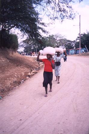
Edward (left), Dale (middle) and Adam (shirtless) at the Los Tablones hut some four kilometers into the climb of Pico Duarte. |
From the La Ciénaga Park entrance it is a forty-six kilometer round trip to the summit of Pico Duarte. Of the twenty-three kilometer one-way distance, fully eighteen kilometers are traversed in reaching a high camp at La Comparticion. The summit hike is accomplished the following morning.
The following table lists standard locations, all well marked, with their respective distances in kilometers and elevations in meters as shown on a prominently displayed sign at the La Ciénaga Park entrance.
| La Ciénaga | 0.0 | 1,110 |
| Los Tablones | 4.0 | 1,270 |
| La Cotorra | 3.8 | 1,720 |
| La Laguna | 2.8 | 1,980 |
| El Cruce | 0.5 | 2,180 |
| Aguita Fría | 3.0 | 2,650 |
| La Comparticion | 4.0 | 2,450 |
| Valle de Lillis | 3.8 | 2,950 |
| Pico Duarte | 1.2 | 3,087 |
The trek commenced at 10:11 a.m. with the day's goal of reaching the high camp at La Comparticion some eighteen kilometers (eleven miles) and over 5,000 vertical feet later.
Quickly it was apparent that mud was a major factor. The mud made for a damningly slower pace than is normal for a broad trail. We reached the first resting point, as the shelter at Los Tablones, after four kilometers and seventy minutes of travel (1,270 meters).
The Los Tablones shelter exists because many trekkers commence their journey late in the afternoon and sleep there as the first night in the backcountry. They proceed to the hut at La Comparticion for the second night.
|
|
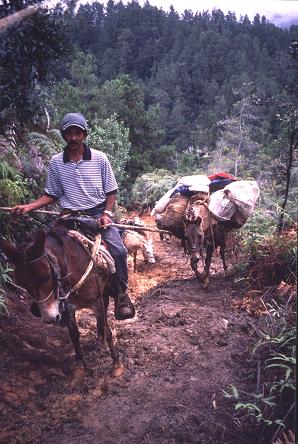
Ubino and a pair of mules during the long ascent to our high camp at La Comparticion. |
Doubting our resolve, Ubino did not feel that we could reach La Comparticion by nightfall. I repeatedly emphasized, in Spanish, that we had to sleep there in order to realize all of our climbing goals for the following day. We wished to climb both summits of Pico Duarte and Loma La Rucilla - a nearby summit that is the third highest in the Republic (9,900+ feet). Ubino had never heard of anybody attempting such a bold schedule, feeling that we needed four days, rather than three, for such an effort.
After the Los Tablones hut it is another 3.8 kilometers to the next marked point - La Cotorra (1,720 meters). From the elevation differences, it is clear that this second leg of day one is steeper than the first.
The steepness was soon combined with the mud, often four inches deep in the best of places. Dale then had serious doubts about continuing. He offered several nasty remarks regarding my planning of the trip, and then abandoned the effort after some six kilometers from the Park entrance.
I feel that Dale quit because of disinterest more than simply being heavier than the rest of us. After all, he had the option of riding a mule uphill but elected to not do so. I am disappointed with his decision, not merely because he essentially wasted his time and money in coming along - but largely because I see now the futility of ever hiking a challenging mountain with him ever again. He simply is not willing to suffer, as is often required, to reach the summit.
Dale's spoken interest in nice hotel rooms, and his concern about how many nights he must sleep in a tent further dampen my desire to invite him on future montane adventures. Given his attitude, I am frankly amazed that he successfully climbed Kilimanjaro with me back in 1996!
Despite all of the above, it must be noted that Dale largely paid for my trip - one which I may have not attended had he not done so. I am very appreciative of this gesture. Unfortunately for Dale, one cannot purchase resolve with cold cash.
The next marked point is La Laguna 2.8 kilometers after La Cotorra (1,980 meters). The mud was still an issue proceeding there, and, to make matters worse, we were enveloped in mist and cloud that dampened our clothing. No views were to be had.
There follows a steeper section that leads to El Cruce after an official distance of just 0.5 kilometer (2,180 meters). This is surely an underestimate of the true walking distance since it results in the unreasonably large mean slope of 40% (as 200 meters / 500 meters). Furthermore our experience along this section suggests a considerably lower slope over a greater distance than 0.5 kilometers. It may be that the 0.5 kilometer figure is the straight line distance without account taken of the tortuous bends in the trail.
|
|
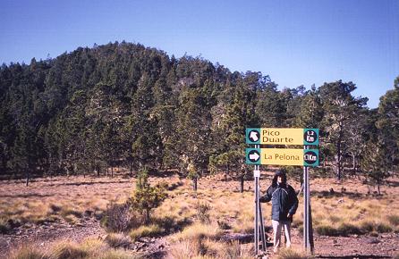
The trail junction at Valle de Lillis. Bob Packard poses under the sign. |
After El Cruce is a moderately steep 3 kilometer section wherein the mud was largely absent. Here the pine forest begins - a related observation. This section has the most elevation gain of any, as it leads to Aguita Fría (2,650 meters) some 1,500 vertical feet higher than El Cruce.
The trail tops out about 100 vertical feet higher than Aguita Fría along the northeast slope of a hill shown on the Park entrance map as Cerro Yaqui of elevation 2,751 meters (9,026 feet). The trail then descends gradually to Aguita Fría, and we took a well-deserved break along this section from perhaps 5:10 to 5:30 p.m.
Since the La Ciénaga trailhead is at 1,110 meters, the net elevation gain is 5,150 vertical feet for day one, i.e. the elevation difference between Aguita Fría and the trailhead (1,540 meters = 5,050 feet), plus one hundred feet.
After Aguita Fría is a descent to La Comparticion (2,450 meters), albeit with some 300 feet of uphill travel as well. In addition there is some 200 feet of elevation loss in leading from La Ciénaga to the trail high point, much of which occurs immediately after departing La Ciénaga, and all of which must be regained. Thus the total elevation gain for day one, from the Park entrance at La Ciénaga to the high camp at La Comparticion is 5,150 + 200 + 300 = 5,650 vertical feet.
|
|
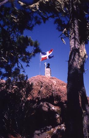
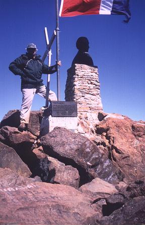
The summit rocks of Pico Duarte feature a bust of Señor Duarte and the Dominican Republic flag. |
We consumed about eight and one-half hours elapsed time for the effort - a figure that would have been closer to six or seven hours had the trail been dry.
We were the only party at La Comparticion, and, with plenty of space, spread out our sleeping bags and gear inside the large, wooden hut designed for sleeping trekkers on a first come, first served basis.
We prepared and ate our own meals in a smoke-filled structure dedicated solely to food preparation. The smoke was at times intolerable, causing Edward and myself to tear on occassion.
Friday, January 21 - Day Two Pico Duarte
This was a good day from the twin perspectives of weather and trail condition. We departed at 7:48 a.m. for Valle de Lillis - at 2,950 meters the trail junction from which one ascends either Pico Duarte itself and/or its sister summit Pelona Chica. Pico Duarte is the southeast summit, Pelona Chica the northwest summit, with perhaps one kilometer straight line distance between the two and a five hundred foot elevation drop to the intervening saddle.
As seen from the photograph (at above right), when at Valle de Lillis, being east of the twin summits, Pico Duarte is available via the left junction, Pelona Chica via the right junction. There is an automated weather station at Valle de Lillis.
Edward and I reached Valle de Lillis ninety minutes after leaving La Comparticion. I estimate a summed elevation loss of 150 feet for this section.
There was some overnight icing - a negligible amount that was more amusing than of concern. Bob and our muleteer arrived perhaps ten minutes later.
We decided to hike Pelona Chica first since we felt that it was more likely than not that Pico Duarte has the 10,000+ foot prominence that we had come for - and we wanted to save the higher summit for last. True enough, and using a less than perfect hand level (which consistently reads 1% too low), Bob and Edward determined that Pelona Chica is some four meters lower than Pico Duarte.
There is a lookout tower on the summit, and the Pelona Chica benchmark is situated on the highest rock outcrop - located perhaps a dozen meters in the direction of Pico Duarte from the tower.
Bob and the muleteer returned to the trail junction and hiked the trail for Pico Duarte's summit. At the saddle Edward and I went cross-country up the northwest flank of Pico Duarte, intersecting the summit trail in time.
The very highest ground is atop a twenty foot tall mass of boulders, and is adorned with a monument and plaque to Señor Duarte.
The summit views were good with clouds obscuring low regions, yet leaving unobstructed vistas for much of the higher terrain in all directions. We spent fifty-five minutes, eating lunch and taking photographs.
|
|
Bob Packard at the summit of Pico Duarte. |
I returned to La Comparticion at about 1:50 p.m., some six hours after having left camp. Bob and Edward followed along with the muleteer and his beast of burden - one taken along, as always, in case of emergency.
The net elevation gain from La Comparticion to Pico Duarte is 2,100 feet over five kilometers. The total elevation gain is 300 feet more owing to 150 feet of loss between camp and Valle de Lillis - 2,400 feet. Since we also climbed Pelona Chica another 500 feet is added, so making for 2,900 feet of elevation gain for climbing both peaks from La Comparticion.
That afternoon and into the evening a throng of hikers arrived, their numbers exceeding one hundred and creating a crowded, messy, and noisy time for everyone. We three slept again in the wood dormitory, this time with perhaps two dozen Dominicans, all young people in their teens. They were on a five-day trek with only some of them arising early the following day for Pico Duarte. January 21 is El Dia de La Altagracia - a national holiday that sees many people on vacation.
I was amused by how concerned most hikers were to the mild evening chill. Many teenagers were bundled up in clothing that I considered superfluous in the 40 F temperatures. I interpret this behavior as expected (even if not reasonable) for people who live their entire lives in eighty degree heat.
Elevations of Pelona Chica and Pico Duarte
Several values for the elevation of Pico Duarte have been found on the Internet, including 3,087 meters (10,128 feet); 3,108 meters (10,196 feet); and even 3,175 meters (10,416 feet). A definitive reference for the height of Pico Duarte is available. Upon correction for deviations of the WGS84 ellipsoid from mean sea level, the author provides an elevation of 3,098 meters (10,164 feet) for Pico Duarte with 4.5 meters accuracy.
In that work the author reports a lower elevation for Pelona Chica (relative to Pico Duarte) of some 4.3 meters (14 feet), so giving it an elevation of 3,094 meters (10,151 feet) with the same accuracy. These observations are consistent with our measurements, wherein roughly a four meter difference was found in favor of Pico Duarte being the higher summit.
I recorded two GPS readings at the Pelona Chica benchmark (WGS84 datum):
(19° 01' 55.7" N, 71° 00' 18.4" W) at 10,086 feet and
(19° 01' 55.7" N, 71° 00' 18.5" W) at 10,101 feet.
It is noted that these values are relative to the WGS84 reference ellipsoid, i.e. correction for deviations relative to mean sea level have not been performed. The corresponding WGS84-based GPS readings of the article's author, prior to corrections for deviations of the WGS84 ellipsoid from mean sea level, are reported as 3,066.4 meters with 2.5 meter accuracy (10,060 feet).
The discrepancy between the author's GPS readings and the above two values is attributed to the superior quality of the author's unit; and because I had taken just two readings in rapid succession. Our goal was to climb the two peaks and not perform a rigorous scientific study. In contrast, the article's author reports having taken thousands of readings over several hours to allow for data averaging. His GPS-based readings, sponsored by the National Science Foundation as part of a larger effort involving tree ring growth studies, were clearly the chief goal of his climbing efforts.
The article's author reports the horizontal coordinates for Pelona Chica as (19° 01' 55.29" N, 71° 00' 18.93" W) with 0.03" accuracy. My pair of values differ from this by about one-half arcsecond, some fifty feet - about the same magnitude of the deviation in the vertical coordinates (roughly forty feet). Similar deviations on the order of fifty to one hundred feet have been found when using my GPS unit elsewhere. These deviations arise even when the unit claims an error radius (actually, an error sphere) of just thirty feet.
Saturday, January 22 - Day Three Pico Duarte
Bob, Edward and I were to have climbed Loma La Rucilla the previous afternoon. However we learned that the trail up Rucilla commences from near Aguita Fría and not from the saddle connecting it with the Duarte summit pair. Thereby it was convenient to climb Loma La Rucilla on the hike out.
After our Pico Duarte trek we wished to climb Loma Alto de La Bandera - the third most prominent summit of the Dominican Republic. To this end we required rental of a high clearance, four wheel drive vehicle from Jarabacoa - which, although difficult to achieve, would be possible with sufficient time the same evening as our descent.
To reach Jaracbacoa by 6 p.m. meant returning to the trailhead by 4 p.m. The five hour climb of Loma La Rucilla in addition to the normal descent from La Comparticion suggested a pre-dawn start at 5 a.m. None of us liked that idea. We canceled Loma La Rucilla in favor of sufficient time to acquire transportation for Loma Alto de La Bandera.
Bob Packard alone climbed Cerro Yaqui on our descent, entailing some 300 feet of elevation gain in addition to the standard effort of returning to the La Ciénaga trailhead.
The total elevation gain for returning to the La Ciénaga trailhead is calculated as follows. There is 200 meters (650 feet) of net gain from high camp to Aguita Fría; 300 feet owing to downhill sections that must be regained from high camp to Aguita Fría; 100 feet from Aguita Fría to the trail high point; plus 200 feet of gain from Aguita Fría to the trailhead - in total 1,250 feet.
Thereby our three day trek entailed a total of 5,650 + 2,900 + 1,250 = 9,800 vertical feet of elevation gain. Bob Packard gets to add 300 more from having climbed Cerro Yaqui. Future hikers who climb just Pico Duarte must expect 9,300 feet of total elevation gain. In all cases the net elevation gain is 3,087 - 1,110 = 1,977 meters - some 6,500 feet.
|
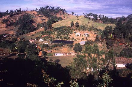
| The Dominican countryside between Jarabacoa and Constanza. |
Sunday, January 23
We arose at 6 a.m. and departed at 7 for Constanza, a farming community nestled in a circular valley at over 4,000 feet in the heart of the Cordillera Central. Our primary goal was securing permission to drive the summit road for Loma Alto de La Bandera.
My contact in Santo Domingo, Manuel Ortega, had failed to secure the required permit prior to our departure. An E-mail message dated from January 19 indicated that Manuel eventually succeeded - but since he had provided no telephone number there was no way of learning this once we were in the Dominican Republic.
We attempted in vain to obtain permission from the military fort at Constanza. The irony is that the permit was available - had we merely asked it would have been found.
I rewarded myself for Pico Duarte with even more than my usual pint of ice cream. Meanwhile Ubino had bought chicken with boiled plaintain for all of us. I resented this because it was impossible to both eat the chicken, only good while hot, and the ice cream, destroyed once melted, as passenger strapped to the seat and with no means of either reheating one or refrigerating the other.
Ubino repeated this stunt a few days later - he provided Bob and I with food and drink just when we were trying to conduct important business in our efforts to find the starting point for a climb of Loma Gajo en Medio. I am certain that Ubino meant well - however his timing in both cases was absolutely atrocious.
We continued south on the road leading to Valle Nuevo and the eponymous scientific reserve. At Valle Nuevo, some 7,500 feet elevation, we encountered a military outpost right next to the approach road that climbs Loma Alto de La Bandera clear to the summit antenna complex.
|
|
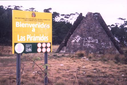
A pyramid marks the geographic center of Hispaniola. |
Despite considerable effort, including an offer of up to $60USD, our request to drive the road was denied time and again. The summit is manned 24 hours. Thereby the guards would have a lot of explaining to do should we show up, without a permit, and be questioned at the summit. We now understood why our bribe was denied - the Valle Nuevo guards would have gotten in serious trouble had they permitted our passage.
We continued south to Ocoa, stopping briefly at a pyramidal monument that presumably is located at the island's geographic center. The terrain was quite mountainous, more than the Pico Duarte area, the ridges often razor sharp with no obvious means of support. With the rough driving behind us we continued to Bani - a modestly sized city on the main highway grid.
After securing a motel room we enjoyed dinner diagonally across the intersection. I finally ate mofongo as planned - a heavy main dish with plantains, garlic, and chicharrones (pork rinds). My version had longaniza (spicy sausage) replacing the rinds. Ubino's mondongo, a completely different dish, was sampled. A simple salad appetizer, two amaretto drinks (one with milk), and orange slices in extremely sweet sugar syrup for dessert completed my meal.
Monday, January 24
Bob and I had two days to explore the country. We independently decided, in the middle of the night, that we would rather attempt another mountain rather than sit, bored, in a Santo Domingo motel room and play tourist. In contrast Edward's return flight was midday. Thereby we put Edward on a bus bound for Santo Domingo, while Ubino, Bob and I drove west on highway 2 towards the Sierra de Neiba mountain range near Haiti.
Our goal was to climb Loma Gajo en Medio - the final ultra prominence in the Dominican Republic. Prior to departure I had amassed enough data on this mountain to admit of the possibility of climbing it with much luck and perseverance. There were no real maps, rather, only a "pseudomap" created using Edward's Winprom prominence calculating program and based entirely on raw elevation data from Space Shuttle radar returns (SRTM). I also had my GPS unit to compare our location in real-time with the pseudomaps I had brought.
|
|
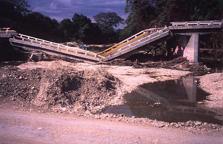
A collapsed bridge along Highway 2 west of Bani while traveling to Las Matas de Farfán. |
After some four hours it was just past noon, having driven a side road south from highway 2 to the community of El Cercado near the northeast side of the Sierra de Neiba. One leaves route 2 at Las Matas de Farfán to access El Cercado.
From the town square one drives generally east and southeast on three successively lesser roads to a rustic set of dwellings at about 3,000 feet. A jeep trail is drivable one-half kilometer beyond the homes to a good starting point beyond which the trail is too rocky to be driven.
The first road is paved and is taken east from the town square until a right turn is made at a sign indicating destinations at 6.5 and 11 kilometers along the road. This junction has GPS-derived coordinates of (18° 42' 53.4" N, 71° 30' 01.4" W) at 2,606 feet (WGS84 datum).
The second road is paved but is severely weathered with potholes, and gains from 2,600 to nearly 3,000 feet elevation. One drives this road until a right turn is made onto a steep dirt road that shortly passes several dwellings. GPS-derived coordinates on this third road immediately beyond the aforementioned junction with the second road are (18° 41' 21.4" N, 71° 29' 53.4" W) at 3,000 feet (WGS84 datum).
At these dwellings we parked and located Victor - a black man in his twenties who was willing to guide us up the mountain for a 500 peso fee - about $17USD. The route would consume eight hours and so it was necessary to start the following morning, before sunrise, at 6 a.m. We drove the one-half kilometer beyond the dwellings to our would-be trailhead for the next morning - one with GPS-derived coordinates (18° 41' 21.2" N, 71° 29' 54.1" W) at 3,002 feet (WGS84 datum).
Since it was only 2 p.m. we agreed to return to highway 2, at Las Matas de Farfán, and continue west to the border town of Elias Pinas. We then entered Haiti under the armed guard of a Dominican soldier, having walked some 200 meters across the territorio de nadie ("no man's land") without any belongings that would arouse the interest of looters.
|
|
Haitian women on market day walk across the border and trade in the Elias Pinas market. |
Bob and I entered Haiti on a market day, the Haitians walking across to Elias Pinas, and returning, to buy and sell goods in the town market. Haitians appeared to be camped out on the ground with no obvious structure or organization. It was somewhat alarming to see people waiting (or living?) under such conditions.
After returning to El Cercado we found no restaurant. I was willing to simply eat cold food in our motel room - one rented for just 400 pesos (about $13USD) for the night. Ubino insisted on eating a hot meal, and arranged for us all to enjoy one at a private home with a charge. Although the food was delicious, I did not like waiting a full hour at the home's entrance before being seated.
A four inch spider adorned the inside wall near our motel room's door. Bob eliminated it, chasing it outside the room, while I spotted more arachnids, far smaller, each strategically positioned in an upper corner of both the living space and the bathroom. Somehow I slept well.
Tuesday, January 25
We arose at 5 a.m. and departed by 5:20. At the dwellings of the previous day we met our guide, on mule, at a quarter of six. We drove the one-half kilometer to our trailhead and commenced hiking, accompanied by a second person, Franklin, the twenty year old son of the farmer who owns much of the land that we would be passing near or through on our journey. Franklin wore a red beenie.
|
|
Victor and a giant plant on the slopes of Loma Gajo en Medio at perhaps 6,500-7,000 feet. |
I quickly became friendly with both local people and engaged them in Spanish dialogue. Bob Packard, nearly seventy, was understandably the slower of all four. That said, Bob did remarkably well considering the 4,500 feet of net elevation gain to the summit.
I reached the range highpoint with Franklin at about 10:22 a.m., Bob arriving perhaps ten minutes later with the guide (who had left the mule lower down before the route got seriously brushy and steep). The final fifty or seventy-five vertical feet are particularly steep, and the summit mound is best accessed from the east side owing to heavy brush blocking a western assault.
The GPS-derived coordinates of the summit are (18° 38' 09.9" N, 71° 31' 19.5" W) at 7,450 feet (WGS84 datum). These values agree to within one arcsecond, about a hundred feet, with the coordinates of the raw SRTM-derived elevation data: a most pleasing agreement indeed!
The locals independently claimed that this was the highest point in the range. The SRTM data also has a greater point elevation for our high point than for competing high points along the ridge to the east-southeast.
Given the collective data I am confident that we stood at the range highpoint, and, as such, earned the 5,837 feet of prominence for Loma Gajo en Medio.
|
|
There were no views atop Loma Gajo en Medio. Victor wears red, Adam white, Franklin blue. |
Neither Franklin or Victor had brought food - and I was able to share much of my kosher sausage and assorted snack food with them because I was not hungry.
Some intermediate waypoints of our route from trailhead to summit are as follows, all using the WGS84 datum:
| 18° 39' 41.3" N | 71° 30' 01.7" W | 4,945 feet |
| 18° 38' 57.9" N | 71° 30' 22.4" W | 6,141 feet |
| 18° 38' 47.5" N | 71° 30' 35.4" W | 6,381 feet |
| 18° 38' 37.7" N | 71° 30' 50.5" W | 6,944 feet |
| 18° 38' 25.5" N | 71° 31' 00.4" W | 7,283 feet |
We departed after twenty-five minutes, about 10:50 a.m., and returned to the trailhead at 1:45 p.m., some eight hours after departure. We had descended a different route that went through crop fields. Franklin cut raw sugar cane for the two of us, and I found it to be both sweet and juicy.
There is a short, downhill section immediately before the final summit mound. The elevation loss is perhaps fifty feet, and makes for a minimum total elevation gain for climbing Loma Gajo en Medio of 4,500 + 100 = 4,600 feet.
Since we took a different route (although much lower down) for our descent, our total elevation gain is greater than the above figure due to some uphill travel not encountered on the ascent. I estimate an additional 150 feet of gain, so making for 4,750 feet of total elevation gain. In addition we had originally ascended the west ridge of the summit area, only to return downhill for an eastern approach upon seeing heavy brush. This added another 50 feet of gain, so making the total elevation gain of Loma Gajo en Medio, as we climbed it, as 4,800 feet.
|
|
A pair of families pose for Bob's camera upon return from the summit of Loma Gajo en Medio. |
I gave Franklin $10USD upon learning that he wanted a new watch to replace one presumably lost. He had earned the money in the role of a second local guide and hiking companion.
As we drove east on highway 2, Bob finally managed to get more pesos at a bank to pay Ubino. I got my pint of ice cream, and we stayed at the very same motel room, in Bani, as we had two nights previously. We also ate at the same restaurant, where I enjoyed Paella Valenciana as main dish.
Wednesday, January 26
We arose at the early hour of 4 a.m. in order to meet our flight to San Juan, Puerto Rico at 9:40 a.m. The auto headlights were not functioning properly with only high beam generally available. This was a dangerous situation since sleeping policemen, known as Topes in Baja California, could not be spotted until they were nearly upon us. The headlights of oncoming vehicles were also a problem.
As we drove into downtown Santo Domingo Ubino got lost, which surprised us since this was his country. Bob and I helped out as backseat drivers, and we made the airport just after 6 a.m. with far too much time on our hands.
I was terribly tired and slept twenty minutes on a series of metal chairs in the terminal after checking-in our luggage. The coffee-infused gummi bears helped.
Our short flight was uneventful and we landed in San Juan on schedule at 11 a.m., proceeded thround United States customs and immigration, and rented our economy vehicle from Budget Rent-A-Car with myself as driver.
We left San Juan immediately, driving south on Route 52 with the goal of camping that evening in the Toro Negro Forest Reserve for an early morning hike up Cerro de Punta - at 1,338 meters (4,389 feet) the highpoint of Puerto Rico.
We stopped at a supermarket to reprovision ourselves, and winded up eating a makeshift lunch in the parking lot from the food just purchased. A doughnut adorned with cream topping, green frosting and a maraschino cherry had caught my eye. Bob ate similarly devilish food, such as cheesecake-filled donut sticks and fried potato sticks - by far the least nutritious meals of the entire trip.
Shortly thereafter we crossed Route 143 - a skyline road that runs the length of the central mountain range. Despite the confusing road numbering scheme, the desired route west is indicated by a brown sign with the words "Vista Panoramica". If you religiously follow these signs you are bound to arrive, eventually, at both the Toro Negro Forest Reserve campground, and, perhaps a dozen road miles farther west, at the base of Cerro de Punta.
The skyline road services several small communities. As such delivery trucks are a hazard - far too large to safely negotiate this winding road, they generally honk prior to a sharp bend to alert you of their presence.
I recommend taking the skyline road, route 143, only when the visibility permits fine views. Otherwise, it probably makes more sense to avoid 143 by continuing south on Route 52 until it meets with Route 2 - the main highway which parallels the south shore all the way to Ponce, the second city of Puerto Rico. After traveling west along Route 2 one would then travel north into the cordillera, meeting Route 143 at any of several points along its trek near Cerro de Punta and/or the Toro Negro Forest Reserve.
Camping at Toro Negro costs $4 per person per night. Reservations are required and are made by calling 787-724-3647 or 787-724-3724 and talking directly to the San Juan office for instructions.
Bob and I were the only campers that evening amidst a true tropical rain forest with multiple trails and much to excite an adverturesome person properly inclined. Bob set up his tent in the camping area while I just slept on the driver's seat after eating a supper of hummus with crackers, kosher beef sausage and the last piece of my delectable, sharp Irish Dubliner cheese. Prior to retiring I read certain portions of R. J. Secor's Aconcagua - A Climbing Guide.
|
|
Cerro de Punta as seen from the parking lot on the north side of Route 143. The summit road ascends at lower right, and is hidden from view at this angle. The summit is located on the left skyline between the various antenna masts. |
Thursday, January 27
A series of minor summits were conveniently available from the highway via side roads leading to their respective antenna farms. We "climbed" Cerro Maravillas (1,210+ meters with almost no elevation gain); and Cerro Tres Dias (1,240+ meters) with 200 feet of gain from the main road since the side road had a "No trespassing" sign.
Note: Elevations for all Puerto Rican high points are from the USGS 24,000:1 scale 7.5 minute topographic series with a ten meter contour interval.
We failed to reach the top of Cerro Jajuya (1,300+ meters) owing to heavy brush on a nearby mound that was slightly higher than the one we had mistakenly surmounted. Of these, only Cerro Jajuya has at least 300 feet of prominence, making it a "true" summit. The GPS-derived UTM coordinates for these highpoints are as follows using the Puerto Rico datum in zone 19Q:
| Cerro Maravillas | 758795 E | 2008841 N | 4,044 feet (1,233 meters) |
| (same) | 758797 E | 2008840 N | 4,026 feet (1,227 meters) |
| Cerro Tres Dias | 757926 E | 2009128 N | 4,111 feet (1,253 meters) |
| (same) | 757927 E | 2009126 N | 4,102 feet (1,250 meters) |
| Cerro Jajuya | 756329 E | 2010512 N | 4,302 feet (1,311 meters) |
| (same) | 756329 E | 2010513 N | 4,304 feet (1,312 meters) |
The parking area for climbing Cerro de Punta is at GPS-derived UTM coordinates (755119 N, 2010692 E) at 3,776 feet (Puerto Rico datum, zone 19Q). The elevation is 1,150+ meters on the USGS map. This gravel parking lot is on the north side of Route 143, immediately under the southeast slopes of Cerro de Punta (see photograph). It is also the Cerro Jajuya to Cerro de Punta prominence saddle.
From there a steep asphalt road leads north-northwest up the east slopes of Cerro de Punta. The road curves counterclockwise, eventually heading south on the upper reaches of the mountain. It is slick when damp and caution is advised lest one fall. The final section of road is concrete at the elevation of various summit buildings, the direction suddenly shifting west prior to a final counterclockwise loop that leads to the summit lookout area.
The following three GPS readings were taken at the summit (Puerto Rico datum, zone 19Q):
| Cerro de Punta | 754712 E | 2011008 N | 4,396 feet (1,340 meters) |
| (same) | 754713 E | 2011009 N | 4,393 feet (1,339 meters) |
| (same) | 754713 E | 2011010 N | 4,392 feet (1,339 meters) |
Bob and I took twenty-two minutes for the ascent, and, given our relatively relaxed pace, we could not have traveled at more than 2 miles per hour. I thereby estimate the one-way distance as two-thirds of a statute mile for the net (and total) elevation gain of 183 meters = 600 feet.
The views were good for most of our summit stay. Eventually clouds starting building in the valleys below and we departed when the views became progressively lousier.
The descent consumed all of thirteen minutes. I do not recommend driving this road - it is really quite steep and, furthermore, the level of effort in hiking from the parking lot is quite minimal in the first place.
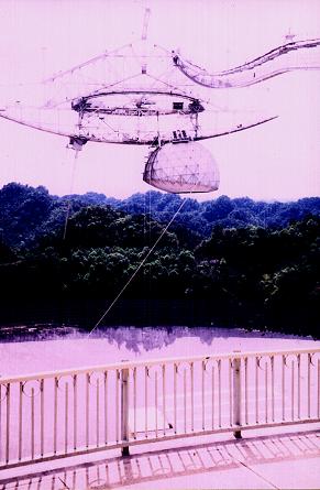
We continued driving west to a junction with route 10, eventually finding ourselves at the Arecibo Radio and Ionosphere Observatory. As any astronomy buff can tell you, the Arecibo dish is by far the largest in the world at 1,000 feet in diameter. I was awed by the scale of the structure, as well as the degree of exacting structural and electronic engineering required to realize this enormous instrument of science.
A museum instructs the tourist in relevant background science, and a gift store provides lasting reminders of the experience. I bought Edward a tee-shirt with the Observatory logo, and a manual containing technical details of the Observatory. Edward would have greatly wanted to visit, but had decided to save his vacation time for other, presumably even more valuable mountain-based trips. I bought myself a tee-shirt with a periodic table of the chemical elements, one wherein the symbols for the radioactive elements glow in the dark. I also purchased a variety of Puerto Rican candy that I have yet to enjoy but look forward to nonetheless.
|
|
The collecting apparatus above the Arecibo radio dish. For various technical reasons the dish is spherical instead of the parabolic shape for most telescopes. |
We had plenty of spare time since it was only 2 p.m. when we drove through the city of Arecibo, and since from there San Juan was less than a two hour drive east. We decided to simply find a motel outside of San Juan, yet close enough to make for a short drive to the airport by morning.
In Vega Bajo we had difficulty locating a motel. After much grief with back-and-forth driving we learned of the El Molino Azul ("The Blue Windmill"). What a bizarre place!
The Molino de Azul charges by the eight hour period instead of by the day. There is a private parking space near the "room" for one's vehicle, with a retractable metal garage door. Your private room is accessed only from the one-car garage, and, in particular, there is no door leading directly to the room from outdoors.
Motel workers drive on golf carts taking notes and provide bathroom supplies. A television camera surveys the outdoor activities between motel rooms. There are mirrors on most walls of the room and no window whatsoever. The room interior is somewhat dark even with all lights turned on.
Yet a 12 x 12 inch chute exists, with a right angle bend, that allows for passage of objects both to and from the outside. The bend precludes both outdoor and room occupants from seeing one another.
Bob and I suspected this motel is designed for people interested in extramarital relations - a concept since confirmed upon discussion with several people.
We showered and ate supper in the room, one that set us back $40USD for the sixteen hour period of its occupancy (as twice the $20USD eight hour rate).
Friday, January 28
The drive to San Juan's airport was during the morning rush hour. Nonetheless, with Bob as navigator I managed to find our way to the Budget return lot without incident.
Our flight to New York City was uneventful except for a trio of suspected criminals who were summarily escorted off the aircraft by TSA (Traffic Safety Administration) officials upon landing at JFK.
I enjoyed mango chicken with rice, and especially the triple chocolate brownie with rum, raisins and milk - the former purchased as a set of three tiny bottles at the San Juan airport that morning.
My flight to San Diego was delayed three hours due to a combination of late inbound aircraft (one hour), and a malfunctioning part that needed replacement (two hours). Fortunately I had three seats to myself, such that I was able to sleep for much of the waiting period as well as during the flight itself.
I arrived at Edward's apartment to claim my vehicle and house keys around midnight. We exchanged comments and I drove home - falling asleep no sooner than 3:15 a.m. after checking my regular mail and eating several goodies that I had not enjoyed for the trip's duration.
Summary
It is a shame that we did not reach the summit of Loma Alto de La Bandera. That said, we had never really expected to climb the greater prize of Loma Gajo en Medio - a true tour de force in both trip planning and availability of local information resources. The real prize, of course, was the 10,000+ foot prominence of Pico Duarte - highpoint of the Caribbean.