
Custom Search
| Tips & Techniques for County Highpointing with Hand Levels * |
Custom Search
|
|
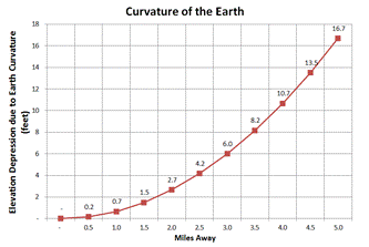
Thus at one mile an object 8 inches higher than the sight leveler appears to be at the same elevation. Similarly, at one-half mile an object at his elevation appears to be 2 inches lower. This correction term is smaller than multiple measurement error sources, which include yet are not limited to
|
|