
Custom Search
| Map and Compass Basics |
Custom Search
|
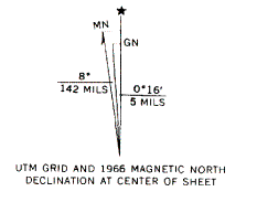 Here is an example of error caused by declination. In Maryland, magnetic north is between 10 and 11 degrees
to the west of true (geographic) north.
Suppose that you are walking towards a destination (in Maryland) that is one mile (1.612 km) away.
If you do not compensate for declination, you will
end up nearly 1000 feet (305 meters) away from the target. Thus for long distances this
amount of error must be compensated for.
The direction you have to travel to get to your destination (waypoint) is usually referred to as the bearing.
Since are 360 degrees in a circle, compass bearings are referenced by the number of degrees
they are away from north, in a clockwise direction. For example, due east is one quarter the way around the circle,
or 090 degrees. In turn, due south is halfway around a circle or 180 degrees, due west is 270 degrees,
and due north is both 360 degrees and 000 degrees.
The numbers on the compass dial (bezel) are the bearings referred to above.
With a compass one may compensate for magnetic declination by positioning the readout dial to adjust
for the declination. Let us say that you want to travel due east. Since true north reads as 10 degrees
east in Maryland, adding ninety degrees gives an indicated (magnetic) heading of 100 degrees.
In southern California the magnetic declination is some 15 degrees east of true (geographic) north.
Thereby true east will be indicated as a magnetic heading of 75 degrees (as 90 less 15).
If you're using a GPS, you can set it up so that it gives directions in magnetic degrees,
thus eliminating the need for compensation.
Finding your way to a destination (Waypoint)
Note: Use GPS only after you are thoroughly familiar and experienced in using map and compass!!
In order to navigate to a destination, which is usually referred to as a waypoint on a GPS, you must know 2 things;
1) Where am I now? and 2) Where am I going?
This may sound simple, but it’s a little more complicated than what we’ve covered so far.
Your location on a map is given in reference to a grid system.
On the USGS topo maps there are two grid systems used; latitude/longitude (L/L) and Universal Transverse Mercator (UTM).
Most people are probably already somewhat familiarwith L/L, but by far the easier system to use on topo maps is UTM.
In this system the world is divided into 60 equal zones from West to East. The West Coast of the US, for example,
is Zone 10 and the East Coast is Zone 18. To see what Zone you are in,
check out here.
On topo maps you will see an occasional marking for latitude and longitude,
but you will see many other marks that represent the UTM grid markings.
On most of the newer maps, the markings are extended into grid lines
covering the whole map, however, you might have to draw in the grid lines on the older maps.
Here's how the UTM grid line system works. The distance between any two grid lines is 1 kilometer (1000 meters).
On the bottom/top of the topo maps, the numbers under/over each grid mark represent the number of kilometers
that mark is east of the start of the zone. On the sides of the topo maps, the numbers for each grid line
represent how many kilometers that line is north of the equator, if you're in the northern hemisphere.
Going south from the equator, the numbers start at 10,000 and
count down from there. In practice three more digits are tacked on to the end of each grid line number.
The purpose of these last three digits is to tell you how many
meters past a given grid line the position is. To give your position, you simply tell how many meters
you are east of the nearest grid line and then how many meters you are north of the nearest grid line.
Remember - east distance ("easting"), then north distance ("northing").
Virtually all 7.5' topographic maps are 1:24000 scale, i.e. 1 millimeter (mm) measured on the map corresponds
to 24,000 mm (24 meters) on the ground. With this knowledge,
all you have to do is take out a small metric ruler (or use the scale on the base of your compass if it has one)
and measure the distance from the given grid line to the
position point in millimeters and multiply by 24. This will give you the number of meters to use in the last three digits
of the UTM coordinate for easting or northing. If you're out in the field and you don't feel like going to the trouble
of actually measuring the distance, you can simply estimate the measurements and get reasonably close.
Now, here's where the GPS enters the picture. Once you have figured out your destination position using the UTM grid lines,
you simply enter those coordinates into the GPS unit as a waypoint. Make sure that your GPS unit will work with
UTM coordinates (most will). Now select that waypoint and use the GOTO function on your GPS unit, so telling
you the distance and bearing from your present position (the GPS knows this)
to the waypoint you just entered. All that's left is to take out your compass, find that bearing, and start walking
in that direction. If you have to make a detour around some obstruction, don't worry about it.
Just check your GPS periodically and it will give you the new bearing and distance to the waypoint.
On most units there is a plotter screen that will draw a line that represents the path you have walked
and a symbol for the waypoint that you have entered. By comparing the two, you can evaluate your progress.
There are a couple of other points that need to be emphasized here. A feature that is commonly overlooked
by the beginning GPS user is the notion of a map datum.
A datum is an attempt by map makers to correct for the fact that the earth isn't perfectly round,
but rather elliptical in shape. Over the years, a variety of different
datums have been developed and used as references on maps all over the world.
The problem that arises from this is that the same position on earth (your house for example)
will have slightly different coordinates depending on the datum used to prepare the map.
The same is true for your GPS. It will give two different coordinates for the
same position, based on which datum you have it set for.
The trick is to make sure that your GPS is set to the same datum that your map is referenced to.
Most USGS topo maps are referenced to NAD27 (1927 North American Datum),
but some of the newer ones use NAD83. This information is printed in the lower left corner of the topo maps.
Once again, BE SURE YOUR GPS IS SET TO THE SAME DATUM AS YOUR TOPO MAP! Failure to do so could result
in errors of 200 meters or more in your displayed position.
Topo maps from other countries may use different datums, but the same rule applies as above.
Consult your GPS owners manual to learn how to set the correct datum to match your map's datum.
One final step is to mention some of the features that can be found on any topographic map. Many features such as
roads, streams, swamps, woodlands (in green), and towns are self-explanatory.
A folder describing topographic maps and symbols is available on request for USGS maps.
For learning purposes, you may wish to examine a topographic map for your area to see how it treats
familiar features and landmarks.
A particularly useful feature found on all topographic maps is the use of elevation contour lines.
These lines connect points of equal elevation above mean sea level (MSL).
Depending on the age (in the US) or country of origin of the map, elevations may be given in feet or meters.
Adjacent lines will increase/decrease at a predefined
contour interval given at the bottom center of the map.
When contour lines are packed together closely, this indicates a rapid change in elevation such as a hill or steep slope.
This may be very helpful when trying to pinpoint your location in an otherwise featureless landscape.
Here is an example of error caused by declination. In Maryland, magnetic north is between 10 and 11 degrees
to the west of true (geographic) north.
Suppose that you are walking towards a destination (in Maryland) that is one mile (1.612 km) away.
If you do not compensate for declination, you will
end up nearly 1000 feet (305 meters) away from the target. Thus for long distances this
amount of error must be compensated for.
The direction you have to travel to get to your destination (waypoint) is usually referred to as the bearing.
Since are 360 degrees in a circle, compass bearings are referenced by the number of degrees
they are away from north, in a clockwise direction. For example, due east is one quarter the way around the circle,
or 090 degrees. In turn, due south is halfway around a circle or 180 degrees, due west is 270 degrees,
and due north is both 360 degrees and 000 degrees.
The numbers on the compass dial (bezel) are the bearings referred to above.
With a compass one may compensate for magnetic declination by positioning the readout dial to adjust
for the declination. Let us say that you want to travel due east. Since true north reads as 10 degrees
east in Maryland, adding ninety degrees gives an indicated (magnetic) heading of 100 degrees.
In southern California the magnetic declination is some 15 degrees east of true (geographic) north.
Thereby true east will be indicated as a magnetic heading of 75 degrees (as 90 less 15).
If you're using a GPS, you can set it up so that it gives directions in magnetic degrees,
thus eliminating the need for compensation.
Finding your way to a destination (Waypoint)
Note: Use GPS only after you are thoroughly familiar and experienced in using map and compass!!
In order to navigate to a destination, which is usually referred to as a waypoint on a GPS, you must know 2 things;
1) Where am I now? and 2) Where am I going?
This may sound simple, but it’s a little more complicated than what we’ve covered so far.
Your location on a map is given in reference to a grid system.
On the USGS topo maps there are two grid systems used; latitude/longitude (L/L) and Universal Transverse Mercator (UTM).
Most people are probably already somewhat familiarwith L/L, but by far the easier system to use on topo maps is UTM.
In this system the world is divided into 60 equal zones from West to East. The West Coast of the US, for example,
is Zone 10 and the East Coast is Zone 18. To see what Zone you are in,
check out here.
On topo maps you will see an occasional marking for latitude and longitude,
but you will see many other marks that represent the UTM grid markings.
On most of the newer maps, the markings are extended into grid lines
covering the whole map, however, you might have to draw in the grid lines on the older maps.
Here's how the UTM grid line system works. The distance between any two grid lines is 1 kilometer (1000 meters).
On the bottom/top of the topo maps, the numbers under/over each grid mark represent the number of kilometers
that mark is east of the start of the zone. On the sides of the topo maps, the numbers for each grid line
represent how many kilometers that line is north of the equator, if you're in the northern hemisphere.
Going south from the equator, the numbers start at 10,000 and
count down from there. In practice three more digits are tacked on to the end of each grid line number.
The purpose of these last three digits is to tell you how many
meters past a given grid line the position is. To give your position, you simply tell how many meters
you are east of the nearest grid line and then how many meters you are north of the nearest grid line.
Remember - east distance ("easting"), then north distance ("northing").
Virtually all 7.5' topographic maps are 1:24000 scale, i.e. 1 millimeter (mm) measured on the map corresponds
to 24,000 mm (24 meters) on the ground. With this knowledge,
all you have to do is take out a small metric ruler (or use the scale on the base of your compass if it has one)
and measure the distance from the given grid line to the
position point in millimeters and multiply by 24. This will give you the number of meters to use in the last three digits
of the UTM coordinate for easting or northing. If you're out in the field and you don't feel like going to the trouble
of actually measuring the distance, you can simply estimate the measurements and get reasonably close.
Now, here's where the GPS enters the picture. Once you have figured out your destination position using the UTM grid lines,
you simply enter those coordinates into the GPS unit as a waypoint. Make sure that your GPS unit will work with
UTM coordinates (most will). Now select that waypoint and use the GOTO function on your GPS unit, so telling
you the distance and bearing from your present position (the GPS knows this)
to the waypoint you just entered. All that's left is to take out your compass, find that bearing, and start walking
in that direction. If you have to make a detour around some obstruction, don't worry about it.
Just check your GPS periodically and it will give you the new bearing and distance to the waypoint.
On most units there is a plotter screen that will draw a line that represents the path you have walked
and a symbol for the waypoint that you have entered. By comparing the two, you can evaluate your progress.
There are a couple of other points that need to be emphasized here. A feature that is commonly overlooked
by the beginning GPS user is the notion of a map datum.
A datum is an attempt by map makers to correct for the fact that the earth isn't perfectly round,
but rather elliptical in shape. Over the years, a variety of different
datums have been developed and used as references on maps all over the world.
The problem that arises from this is that the same position on earth (your house for example)
will have slightly different coordinates depending on the datum used to prepare the map.
The same is true for your GPS. It will give two different coordinates for the
same position, based on which datum you have it set for.
The trick is to make sure that your GPS is set to the same datum that your map is referenced to.
Most USGS topo maps are referenced to NAD27 (1927 North American Datum),
but some of the newer ones use NAD83. This information is printed in the lower left corner of the topo maps.
Once again, BE SURE YOUR GPS IS SET TO THE SAME DATUM AS YOUR TOPO MAP! Failure to do so could result
in errors of 200 meters or more in your displayed position.
Topo maps from other countries may use different datums, but the same rule applies as above.
Consult your GPS owners manual to learn how to set the correct datum to match your map's datum.
One final step is to mention some of the features that can be found on any topographic map. Many features such as
roads, streams, swamps, woodlands (in green), and towns are self-explanatory.
A folder describing topographic maps and symbols is available on request for USGS maps.
For learning purposes, you may wish to examine a topographic map for your area to see how it treats
familiar features and landmarks.
A particularly useful feature found on all topographic maps is the use of elevation contour lines.
These lines connect points of equal elevation above mean sea level (MSL).
Depending on the age (in the US) or country of origin of the map, elevations may be given in feet or meters.
Adjacent lines will increase/decrease at a predefined
contour interval given at the bottom center of the map.
When contour lines are packed together closely, this indicates a rapid change in elevation such as a hill or steep slope.
This may be very helpful when trying to pinpoint your location in an otherwise featureless landscape.