Arizona Prominences May 2010 Trip Report
© May 2010 Adam Helman

Note: Click on any image for enlargement.

Introduction

Mid-season peaks of intermediate elevation are best suited for Spring and Fall. Examining assorted statewide prominence maps, I concoct a plan to bag enough of them near the Arizona / Nevada / Utah tripoint so as to make the trip worthwhile despite gasoline expenses out of San Diego.

Two main issues require special consideration. One is the substantial remoteness of some peaks from both pavement and any services. The other is snow atop the Kaibab Plateau. Both issues transform the trip, making it a memorable if not entirely successful experience.

The venues in chronological sequence -

The "Strip" is all of Arizona north of the Colorado River. There are very remote areas based on distance from any community and hence services in event of trouble. There is no pavement for hundreds of miles - raising the serious possibility of two flat tires before they can be repaired or replaced.

remote road sign
This sign along BLM 101 has
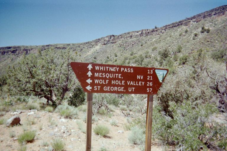
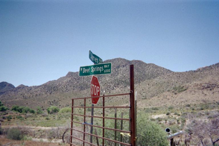
incorrect mileages. Whitney Pass
is 15 miles; Mesquite is 47 miles
in the indicated direction.

Wolf Hole Valley is unpeopled.

A driving route is chosen which leaves pavement 3 miles south of Exit 112 on Interstate-15 in Nevada; proceeding south and then east for Virgin Peak, Mount Bangs, and Mount Trumbull. Return to pavement is estimated 220 miles later seven miles west of Fredonia, Arizona on Route 389. Any driving route returning to pavement between the peaks is less efficient.

My pickup truck "DENALY" can travel 380 miles on a full tank - normally. Based on these figures I deem the plan satisfactory. To hedge against an automobile breakdown I take 7 gallons of water plus orange soda pop and canned vegetables. I also tried unsuccessfully to borrow a second spare tire from neighbors.

The remaining venues require Arizona Route 67 to be open. Its terminus is the Grand Canyon's north rim, and yet is closed every winter until May 15 on account of snow on the 9,000 foot Kaibab Plateau. This date sets the trip's start as May 12, timed so as to reach AZ-67 on the 15th or later.

From this paved road branch numerous unmaintained Forest Service roads. Bob Packard reminds me of the obvious - that even though Route 67 is open there's no guarantee that the dirt roads will be snow-free. Somehow I dismiss the comment - and with plan-altering consequences.

I rent an Iridium satellite telephone so my "base camp manager" can have piece of mind once she learns how remote I will be for three days - and alone. It arrives May 11 the day before I drive ... and is defective. The unit is returned to Florida, and I delay the journey two days so as to obtain a replacement on May 13 - driving the next day as the trip's new start date.

overall route
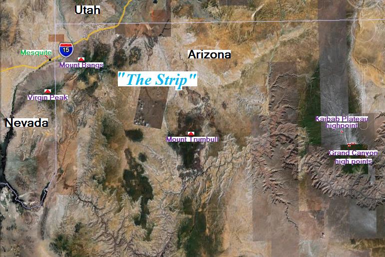
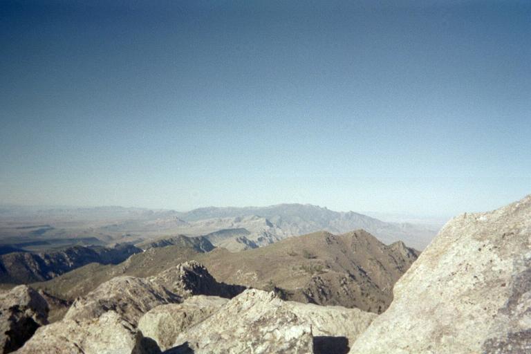
The overall plan is outlined. Map dimensions are
roughly 200 miles east-west and 150 miles north-south.

Trip Details

Friday, May 14 - to Nevada

It's 405 miles to Mesquite, Nevada. There the tank is completely topped-off; and I return west eight miles to Exit-112 on the interstate. Three miles later I'm on New Gold Butte Road, which I take 21 miles to leave pavement at Whitney Pocket.

I now drive 2.4 miles east to a junction, and then north on rocky road 0.9 mile to a remote junction, having passed a derelict corral after 0.7 mile. At the junction I reluctantly pull-off and park on an incline, there being no level place whatsoever except on the junction itself. It is just after 4 p.m., and my GPS unit reads 4,197 feet elevation.

A nearby hill is climbed about 500 or 750 feet north in the attempt to get a cell phone signal - without success. An expensive call is made to my mother using the satellite phone. Knowing my precise coordinates is somehow important to her.

To my dismay I find that the macaroni and cheese packets for some suppers were not packed. Instead I use crumbled matzoh inside water, which on heating gives the consistency of pasta. Adding cheddar cheese (well, Velveeta cheese food) the pot of "mush" becomes inviting and tasty. There's leftover chicken livers too; and extra hot Indian vindaloo curry paste for more flavor. A fresh grapefruit cools the fire.

This evening multiple commercial jets fly into Las Vegas from points east - and continue even past midnight as folks eager on a weekend of losing their money head into Sin City. Apart from the aircraft there is no sign of human civilization. I am cut-off.

rock     snow
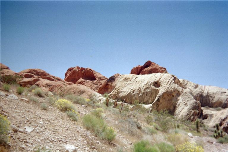
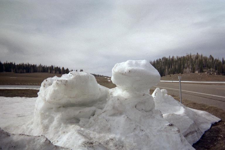
Desert multicolored rock and a bizarre snow formation
highlight the two faces of this journey.

A vertical line separates the rock colors, each side of
a different time and origin (click to see clearly).

Remarkably, the two rock masses and pair of snow projections
seem to mirror each other. It took a lot of searching to
secure this result.

Saturday, May 15 - Virgin Peak

Don't climb Virgin my way. The available route information was simply too scanty; and so I created my own route - one which could have been much easier as described below.

I arise at 4:24 a.m., have Raisin Bran with milk, and walk by 5 'till 5 carrying four quarts, initially northeast and then more northerly. The pace set is rapid, and I pass by a showstopper for vehicular traffic 14 minutes later at a choke point in the canyon. This boulder is likely placed here intentionally, as the canyon is at its narrowest, such that it cannot be bypassed by four-wheel vehicle. An ATV would probably work.

After one hour I've traveled 3 miles and gained 1,400 feet. The road now deteriorates into a washed-out gulley with steep, tall sides. No vehicle can possibly use it here. Thirty minutes later I'm at a 6,300 foot "road" junction where I note that Virgin Peak's summit is only about 3/4 mile west northwest.

But WHAT a 3/4 mile!

I had used the existing road grid for as long as I could because the brush on either side looked most uninviting for a bushwhack. I continue northwest on a trail which is shown on the topographic chart, continuing to nearly its end at the base of an east-southeast ridge.

The ridge is climbed for 600 vertical feet right along its spine as the brush is less heavy there. Now I'm only 900 feet below the summit.

There are cliffs blocking a direct passage. I bushwhack northwest, intending to hit the north summit ridge where it appears to be a bit less dicey. I reach the north ridge about 550 feet below the summit, and find that the ridge is impossible to climb without technical rock gear.

Uncertain how to proceed, I sidehill-contour south, passing under the main ridge to its east. Further progress is feasible but it entails some short high-angle rock scrambling. I have no choice - and, realizing how remote I am, most carefully climb this steep, 15 foot tall section to find that the remaining route, at least initially, seems doable.

Passing by a melting snow patch, I'm now only 250 feet below the summit. There is a steep slope to my left (east) which leads more directly to the top of the east-southeast ridge I took: and I both mentally note this location and save a waypoint.

The final 150 vertical feet is above the imposing east-facing cliff bands and poses no problem.

The summit has superlative views of Nevada desert to the northwest, with both Mesquite and long-haul trucks visible along I-15 some 6,500 feet below.

The cell phone works, and is used in preference to the satellite phone because it is vastly cheaper. I call my mother. Gosh she is happy to hear from me!

I enjoy pastrami on a kaiser roll with mustard - lunch food even though it's only about 9 a.m.

My descent follows the steep, more direct route to the east-southeast ridge; and then retraces the ascent path. I reach the truck around 1:30 p.m.

An easier means of climbing Virgin Peak would be to follow its south ridge. The question then is, where does one leave the jeep track, westbound, bushwhacking towards the ridge? I cannot say for certain - although such a route appears to entail much less navigational and potential technical issues than my experience.

I am not happy driving across into the Arizona Strip. Nevertheless after 4 or 5 miles I've come to Whitney Pass and then drop down into the adjacent valley along BLM 101. There is a critical road junction where one bears right. A second road junction is shown as "Jacob Wells" on the map, about 13 miles beyond Whitney Pass. Here I bear left (north) onto BLM 1004, and take it 9.6 bone-jarring miles to an abandoned brick structure near the road where I camp.

brick building
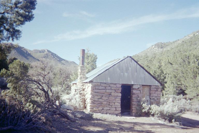
Abandoned brick structure.

Mount Bangs' summit is just left
and level with the chimney's top.

This road is at-times most slow. After about 3 miles is a steep section that will probably stop underpowered vehicles. After about 7 miles is a pair of switchbacks that takes one over a pass which from a distance seems impossible to reach by vehicle. After 8 1/2 miles is a patch of flat grass, ideal for camping were it not that another nearly 2 miles of driving is possible to the trailhead.

A mere 200 feet north of the brick building is a junction; with yet another junction 200 feet farther north. I found no place to camp near these junctions.

The fuel gauge shows one-quarter tank used even though I've driven just 64 miles since Mesquite. At highway speeds I'd reach the same indicated fuel level after going 95 miles. Given that the first 32 miles were on pavement, the implied rate of fuel consumption for the dirt portion is alarmingly large. Something is wrong.

I now assume that the same rate of fuel consumption might apply for the remainder of my time in the Strip. Estimating road distances I conclude that, although I can probably return to Fredonia safely, I might not be able to should I add a visit to Toroweep Overlook - a most spectacular yet rarely visited place to view the Grand Canyon and highly recommended.

I decide to abandon Mount Trumbull since Toroweep is definitely on my list. No sane person would willingly run out of gasoline given the circumstances. In fact, now I am even more remotely located than last night.

Supper includes a pint of beans in brown sugar syrup with much added pastrami - and crumbled matzoh as "crackers".

Tonight there is no jet traffic, and I surmise that the majority of flights arrive specifically on Fridays.

ridiculous signs     ridiculous sign
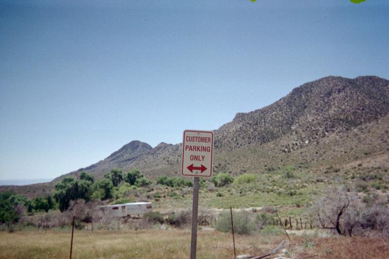
About one mile east of Whitney Pass, at an abandoned
ranch home, one finds these inappropriate signs along BLM 101.
The owner jokingly implies this is a city intersection;
and that his grass lawn is only for visiting "customers".

In truth the area is stark, desolate, and remote.

Sunday, May 16 - Mount Bangs

Conditions have changed since posted reports for climbing this mountain. The road shown heading north from Cougar Spring is now dead-ended as a trailhead 0.6 mile from the pair of road junctions noted above. Beyond that is designated Wilderness Area with no motorized travel allowed.

From that 6,300 foot location it takes me 30 minutes to reach the obvious saddle northeast of Bang's summit at about 6,900 feet. There is a pond.

An old road ascends generally west, contouring around some hills. After climbing 250-300 feet from the saddle there is a fork. Here bear right and briefly head east before doubling-back west and resuming upward progress.

The road peters out to become a foot path, and, some 500 feet below the summit, vanishes alltogether. From here the best route is not obvious. Impeding a direct ascent of the ridge is nasty foliage. However orange flagging provides clues to a faint trail which wends its way through this mess.

The final 200-300 vertical feet is a rock scramble. I go directly "up" the ridge, negotiating a steep, ten foot section with less angulated terrain beyond. It is Class 3 at-times, no problem, except that plants annoyingly get in the way.

Mount Bangs route
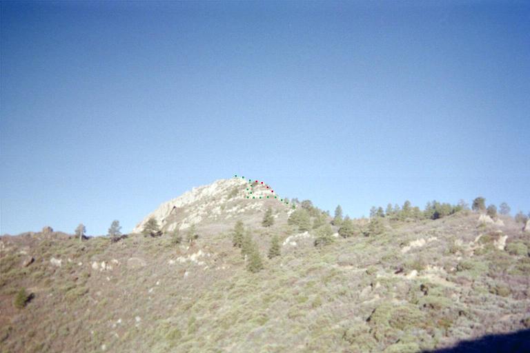
Mount Bangs from the 6,900 foot saddle.

Green squares indicate the
simplest route; red squares
follow the ridge and is dicier
(click to see clearly).

Summit views are wonderful - and my cell phone again works to get out a message.

I descend the north ridge and, in an effort to avoid downclimbing the steep section veer right (east) down a flagged path which eventually joins the same path I took on the ascent before encountering steep rock.

In review, on reaching the upper end of the nasty brush, and with an imposing rock face above you, veer left (east) to follow a flagged route as it travels clockwise around this impediment, eventually zigzagging up the east slope to meet the main summit ridge about 100 feet below the summit and perhaps 300 or 400 feet to its north. Follow the ridge south to the summit.

I return to the trailhead before 10 a.m., the round-trip consuming perhaps 3 1/2 hours. I detest the concept of driving BLM 1004, and am glad it's overwith after about an hour. BLM 100 is taken to Whitney Pass, and, shortly after, I'm back on pavement with all four tires unharmed. My truck is the true "star" of this trip!

At Mesquite I caffeinate and drive northeast by 1:45 p.m. It's 175 estimated miles to FR422 as it branches off of AZ Route 67 just north of the Grand Canyon north rim entrance station. The road is signed "FR22" even though the Kaibab National Forest map shows the road as "FR422".

Virgin from Bangs
Virgin Peak seen from
Mount Bang's summit.

There is snow just about everywhere. Several vehicles are parked at the forest road's start, before a patch of white impeding progress. I park and walk to the snow, noting the tire tracks. If it were simply a matter of this one patch I'd consider driving it. However it's nearly certain that more patches are beyond - making it pointless unless one can drive across every patch of snow.

I've read many stories of county highpointers getting stuck in snow. So I decide right then and there to walk the roads over two successive mornings - tomorrow for the quartet of Grand Canyon high points; and the next day for the Kaibab Plateau highpoint. Snow travel is slower than over dry ground, and I consider over 16 miles too much for a single day even though it would normally be fine. Hence the efforts are split over two mornings.

I drive FR610 east on the highway's opposite side, only to find it too blocked by snow about 200 or 300 yards farther. I back-down in reverse to the main highway, and then drive 5 miles to the park entrance station where I learn about where to park my vehicle the next morning for the first of my two efforts.

With nowhere to go off the main highway, I camp at a pullout 1 1/2 miles north of the park entrance station. Anybody desiring solitude would be horrified by this idea. However I have little choice.

Monday, May 17 - Grand Canyon high points

Freezing overnight temperatures means it's counterproductive to arise so early. I intentionally do not set the alarm clock to some unlikely hour, rising instead by the sun at around 6 a.m. I switch to sturdier boots that have no holes to allow for snow entry, wear snow gaiters over them, and carry both snowshoes and trekking poles.

The plan is to combine the two efforts normally done separately for reaching the pair of two high point pairs by a cross-country bushwhack as shown in this map. The mouse cursor is centered on the second of four 9,160+ foot contours. From there it is only one-quarter mile northeast to a bend in FR610. This maneuver eliminates several miles along FR610.

At 7:22 I begin at the service road pullout of the entrance station, taking the road, now closed to vehicles, to the North Rim Lookout Tower as the first possible highpoint. From there I return to here, nearly at a bend in the service road, and travel due east to the second possible highpoint.

snow in Park
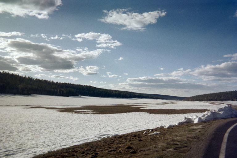
Route 67 runs through De Motte Park
just before the Grand Canyon
north rim entrance kiosk.

Then I head northeast to the bend in FR610, arriving a bit after the desired 9 a.m. The cross-country travel is hampered by mounds of snow interspersed with bare areas. Skiing would be difficult because the terrain has two and three foot tall snow mounds with no flat ground apart from the dry areas. It is constantly up-and-down.

Once at FR610 it is a simple matter of following it east for about three miles to the third and fourth possible highpoints located just to the south. I make good time on both the dry areas and the snow, never finding it necessary to use the snowshoes.

After the fourth contour I return one-fourth mile to this junction, and have lunch on a nice log about 50 feet farther west just on the north side of FR610. It is about 10:30 a.m., and I spend at least 20 minutes eating and hydrating.

Around high noon I am back at the bend in FR610, and, after some delicious Mexican caramel head southwest for 0.38 mile to this bend in the tower service road. By now the snow is soft enough to punch-through, and this fate I suffer at least twice while passing trees with their deep drifts.

I return to the vehicle at 1:26 p.m., roughly six hours after leaving. The weather has turned - it's now no longer sunny and there's a wind. There's a lot of free time. Rather than visit the north rim (for a $25 park entrance fee) I just drive north 0.8 mile past FR422 to a convenience store and enjoy two packages of hot chocolate with leftover snack food - including that truly superb Mexican caramel purchased last month in Durango state.

I park at the start of FR422 and pack for the next morning's effort. It is truly uncomfortable by now, with the wind gusting into the 30 or 40 mile per hour range. I have no idea how supper can be cooked on the tailgate with this wind.

I am soon amused by at least two drivers who attempt to cross the snow patch. One of them spins-out before continuing. I predict that he'll be returning shortly even though he (barely) won that battle. True enough, less than five minutes later he returns - only to try his skill with FR610 on the highway's opposite side. He crosses the first patch, and, as expected, returns a few minutes later.

I did, however, see a Toyota Landcruiser effortlessly drive back to the highway, crossing the first FR422 snow patch without swerving, gunning his engine, or otherwise experiencing apparent difficulty. Now THAT'S a capable vehicle.

Supper is cooked on the leeward side of the vehicle near the right rear tire. It is relatively wind-free, and I enjoy canned salmon inside more "matzoh mush" with Velveeta cheese and plenty of salt for electrolyte replacement.

I learned from the store manager there's a 30% chance of rain tonight, and a 40% chance for tomorrow. It's so odd: there was a "0%" in the forecast before I left San Diego.

topo chart
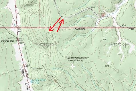
Arrows indicate the maneuver which eliminates several miles of effort
when the Grand Canyon high points must be accessed on-foot.

The northeasterly arrow starts at the 9,160+ foot contour. The southwesterly
arrow ends at a northern bend in the lookout tower service road.

Tuesday, May 18 - Kaibab Plateau highpoint

Yesterday's effort entailed perhaps 10 1/4 miles. Today is shorter and simpler at about 6 1/4 miles - an intentional plan which should allow me to drive farther by afternoon to a decent place for the night.

It rained a bit overnight, and, while eating Frosted Flakes crumbs with milk it begins to snow. Heck, I'd rather trek in a light snow than freezing rain anytime! Incidentally - the cereal is flavored with ground ginger as otherwise it is simply "sweet" with no depth or character to its flavor profile.

The conditions being somewhat uncomfortable, I start with four layers and two pairs of gloves - yet no snowshoes as they were not used yesterday and there's no reason to assume snow conditions have changed apart from the current light dusting.

The weather soon improves markedly, and after less than a mile I am compelled to remove two layers (including my green parka) and replace ski cap with a sunhat.

Two miles from the vehicle I reach the junction with FR270. It is completely snow-covered - such that skiing would save both time and energy. A half hour and one mile later I am at the junction with FR222 and so nearly within the most likely highpoint contour for the Kaibab Plateau.

I head southeast on FR270, and note that it is heading downhill with no higher ground in sight farther along. So I return to nearly the indicated junction and head east into the 9,200+ foot contour itself. I pass a communications shack with tall radio mast; head north, and then west back to the FR222 / FR270 junction where I use a log to enjoy sardines and peanut butter on a large roll and a pecan granola bar. The satellite again works to my mother's satisfaction.

I think it not coincidence the the Forest Service emplaced a radio tower within the topographic contour of interest. Knowing that it commands the highest ground for dozens of miles is ample reason for locating it there.

I return the "ascent" route, the round-trip consuming about 3 1/2 hours. It's only about 10:30 a.m., and after getting into normal clothes and tennis shoes head out bound for a room at the Virgin River Casino and Hotel in Mesquite, Nevada.

Gasoline is purchased at an Indian-run store near the entrance to Pipe Spring National Monument. Prices are tax-free at this station located nine miles west of Fredonia, and two miles west of the junction one uses to access Mount Trumbull. This establishment is important to note if low on fuel when returning from the Strip. The last of my Mexican caramel is enjoyed with mocha and an inch's worth of pecan granola bar.

The shower is very welcome in my $24.95 room. However the TV options are quite limited, and I sleep by 8 p.m. since there is nothing to do apart from gamble.

Wednesday, May 19 - return home

The hotel has four restaurants and an embedded Starbucks. So I get a java chip frappuccino, venti ("large") size, with a cream cheese pastry. This "calorie bomb" is well-earned after my efforts. I arrive in my home community just after 2 p.m. and mail the satellite telephone to avoid a late fee.

treats
Starbucks java chip frappuccino
and a cheese danish await enjoyment -
so fulfilling their destinies.

Summary

The truck odometer reads 1279.4 miles on returning home. These "Adam truck miles" are typically one-hundredth more than standard statute miles, such that the true distance is nearer 1,300 miles.

The time "saved" in not driving 160 slow, gasoline-intensive dirt road miles was used anyway in hiking 16 miles of snow on the 9,000 foot Kaibab Plateau. In essence when I saw that the roads were impossible to drive I decided to make it a "snow opportunity" as I rarely get any of it living in San Diego - rather than just return when the roads are passible some June.

I consider trekking in a beautiful evergreen forest (even when on roads!) as more enjoyable than driving endless miles of bumpy dirt roads in what seems like the "middle of nowhere". It's also more in the hobby's spirit.