Baja March 2009 Trip Report

Dates: March 16 to 19, 2009

Note 1: All UTM coordinates are zone 11 and use the WGS84 datum.
Note 2: Click on any photograph for enlargement.

Overview

My friend Bob Packard wants to bag certain prominent peaks just south of the international border. Economizing, he adds the four mountains of San Diego County with at least 2,000 feet of prominence. I join Bob for the three Mexican summits, having already, of course, climbed the San Diego quartet.

Bob
Bob Packard in my living room.
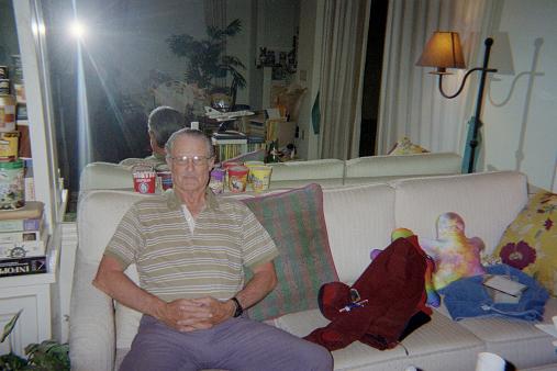
Note the assortment of pillows,
ice cream pints, and the model
F-106 fighter of mahogany.

Local peakbagger Mark Adrian wishes to meet Bob - and so we have a get-together at my condominium, in Carmel Valley, for most of Sunday the 15th. There is a good variety of food and, of course, certain adult beverages - Jose Cuervo tequila and sweet Manischewitz cherry wine.

We enjoy videotapes of Bob Packard's family climb of Aconcagua from way back in 1991; and his ascent of Denali the previous year. I had seen the Aconcagua video, at Bob's Flagstaff apartment, upon completing the Arizona county highpoint list in 2001. Now that I have been to Aconcagua (as has Mark), new significance is given to all facets of its videotape.

Bob has already hiked Cuyamaca Peak this morning. Tomorrow, on the way to Mexico, I join him for Otay Mountain (my third time there). We will enter Mexico at the Tecate border crossing and climb, in order, Cerro Bola, Cerro Pescadores (the Cucapa Range highpoint); and Centinela immediately south of the border. Bob will drive me home and sleep here in his camper. The next morning he will hike Palomar Mountain; following by Whale Peak the next day.

Monday, March 16 - Otay Mountain and Cerro Bola

We drive at 6:30 a.m. to beat San Diego rush hour traffic. Some two hours later we are greeted by a locked gate for an eastern Otay Mountain approach and 0.7 mile along Marron Valley Road from its junction with Route 94 just south of Dulzura. This gate has never been closed in previous reports.

Not willing to simply give up, we return northwest on Route 94 and head west on Otay Lakes Road 2.4 miles to a tiny community with the Pio Pico market. The Minnewawa Truck Trail heads south from here to Doghouse Junction - a route easily driven even though it is rather narrow for its entire length.

Otay Mountain
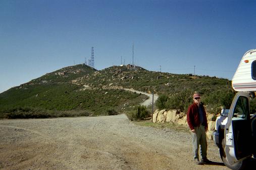
The summit of Otay Mountain
from Doghouse Junction.

We walk all of twenty minutes south along the road as it eventually curls clockwise around the summit. There are nice views of downtown San Diego, the Pacific Ocean, and of the international border with Tijuana immediately to its south. On reaching the summit antenna complex turn right (south) to locate the highest boulders.

Entering Mexico at Tecate is easy - there is no waiting in either direction. We enter just around noon when Bob's insurance becomes effective; and then drive south 19.5 miles (from the border crossing) to the Cerro Bola approach road, signed "microondas" along Mexico Route 3 because of the numerous radio transmitters atop the main summit.

The road gains some 3,000 vertical feet as it switchbacks up Cerro Bola. Plan on one hour for this mechanically-assisted ascent. It is an impressive feat of engineering, this road construction. Some sections are smoothed with concrete - presumably the very worst conditions existed there prior to this improvement.

Bola approach
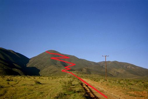
The driving approach for Cerro Bola
as indicated in red.

We park at the main, northeast summit and walk to the nearest high ground on the south side of a fenced area. I obtain (531520 E, 3575285 N) at 1,278 meters.

There are two contending areas for the prominence, located southwest and requiring a bushwhack. We drive down the approach road to its highest bend and park. From here, perhaps 200 feet below the antenna-laden summit, an ATV trail leads generally west, and then northwest. We use this trail to shave-off the total distance we must bushwhack through brush for the remaining areas.

antenna
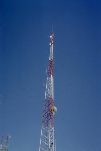
An impressive antenna mast
atop Cerro Bola's northeast summit.

We begin at 2 p.m. and reach the two areas some two hours later. They are less than 1,000 feet apart. The western area features a ten foot boulder climb. From it we sight with Bob's new and reliable hand level to the nearby eastern area and find it to be higher. Back-sighting confirms that the western area is indeed a few feet lower. Sighting to the main summit one mile northeast is unrevealing.

For the eastern area I obtain (529850 E, 3574033 N) at 1,272 meters. For the western area I obtain (529655 E, 3574066 N) at 1,276 meters. The latter reading is higher in elevation, despite our visual observations, as the error in my GPS unit is roughly 5 to 6 meters.

We return to the vehicle after a four hour round-trip. The total elevation gain is 1,700 feet because one must drop down, in both directions, to the 1,050 meter intervening saddle between the main northeast summit and the southwest pair.

We camp here - having already done the bushwhack originally planned for next morning.

I enjoy packaged noodles alfredo with both green beans and canned salmon mixed-in; followed by a slice of Bob's pumpkin pie.

Tuesday, March 17 - Driving Day

Ahead of schedule we could switch plans and climb Centinela this afternoon as it will only take one-half day. However it would be in the day's hottest hours; and would have us returning to San Diego by dark, the next evening, since the Cucapa Range highpoint will consume nearly the entire day to climb.

Given these observations we simply drive today, arriving at the base of the Cucapa Range around 1 p.m. Our route takes us back to Mexico Route 2 on the south outskirts of Tecate; east along Route 2 to Mexicali (scouting the driving approach for Centinela along the way); and then south for roughly a dozen miles on Route 5 to a new road that heads southwest right to the base of the Cucapa Range.

After a lazy lunch we both sleep in the camper for two hours. Around 4:30 p.m. Bob climbs a nearby hill which used to have "seven antennae" at the summit. He returns two hours later, citing loose rock on the descent and thus the advisability of a trekking pole for the next day's long effort. My GPS unit reads 175 meters.

Wednesday, March 18 - Cerro Pescadores

We begin at 6:30 a.m. before sunrise. Heat is the main issue, and I carry 4 liters of water and 2 of Bob's 4 quarts. I can feel the weight of 6 bottles in my daypack.

It takes us nearly one hour to hike southwest along the sandy wash to the base of the ridge we will take clear to the summit. Finished with the southwest travel (one cannot go farther without climbing), one bears left (south) perhaps 200 yards to access the ridge. This ridge is the only (obvious) nontechnical way to gain the main, north-south crest of the range. At the ridge base my GPS unit reads 276 meters - a roughly 330 foot gain from the vehicle. We have 2,600 feet to go.

We ascend the Class 2 ridge for some 500 feet. Then, one turns a bit right and descends perhaps 20 feet at the top of a gulley that serves as an optional ascent route. We remain on the ridge for the entire ascent. There is a 50 foot drop, followed by a more depressing 100 foot drop. Some of the ridge is steep where one must surmount obvious boulder outcrops - and it would be a most circuitous route indeed that would keep this climb below the Class 3 rating it deserves.

descent
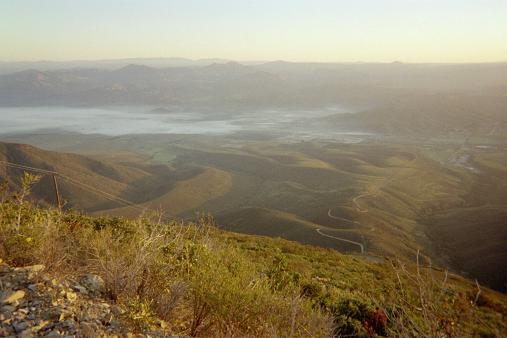
Ground fog during the
Cerro Bola descent.

Perhaps 300 to 500 feet below the summit is a most interesting section with smooth sandstone. A few cairns mark the way. The path through this sandstone area is convoluted yet "works". An overhanging boulder provides morning shade later on, perhaps one-half hour before the summit.

We arrive at the summit just after 11 a.m., having taken more than 4 1/2 hours for the ascent. A more typical time should be 3 1/2 hours from our carpark. Here, recall, that Bob is 72 years old.

Standing 2 meters east of the summit cairn I obtain (646186 E, 3582253 N) at 3,578 feet (1,090.6 meters) with an accuracy of 5 or 6 meters.

The summit features a huge cairn, presumably placed by the DPS (Desert Peak Section) of the Sierra Club. It is hard to decide exactly where the natural rock ends and the emplaced rocks begin. This is an important consideration because two competing summit contours lie to the north - one a mere few hundred yards and the other, with benchmark Potrero, a full mile away and with a 500 foot drop between.

The true highest boulder may be ten feet west of the large cairn. With arms and sight level stabilized atop this boulder, Bob and I independently find that the near summit is lower.

The far summit is more controversial. With the hand level's bubble centered on the middle graduation mark, I find the far summit to be lower than said tick mark roughly 70% of the time. The remainder of the time the far summit appears to be level with the tick mark. Bob obtains similar results - most of the time (as the level jitters) the far summit appears lower or even with the horizontal.

fog
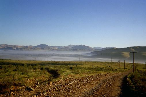
Morning ground fog after
the Cerro Bola descent.

Andy Martin made similar assessments - citing that the near summit is definitely lower while the far summit is, in his words, "possibly lower".

Thus three people independently claim that benchmark Potrero is equal to or lower than the main summit with DPS cairn and register. In addition our summit is more "peaked" than the rather flattish northern summit. However on the map the two 1,080 meter contours are roughly the same size - indirect yet important evidence that the northern summit is lower.

I enjoy a pastrami sandwich on rye bread with mustard - a classic combination. Bob has an assortment of snack food, including granola bars and mixed fruit cup. We depart at 11:54 a.m. and make the long descent - this time with Bob's water absent from my pack as we have both used half our supply.

The descent is more harrowing because of loose rock. Indeed, we return to the vehicle only after another 4 1/2 hours - so making for a 9 hour travel time and a 10 hour round-trip as 6:30 a.m. to just shy of 4:30 p.m. I have drunk all of my water, and yet remain thirsty.

The net elevation gain is 3,000 vertical feet. The total elevation gain, including the 50 foot and 100 drops noted, is just over 3,300 vertical feet.

We return through Mexicali, stopping at an Oxxo convenience store for refreshments. I have a quart of chocolate milk with cookies to both replace water and provide energy - a change from my usual habit of an ice cream pint. Bob has an ice cream bar as "reward".

For Centinela we travel west on Mexico Route 2. Just past a cattle feedlot signed "Karne" at around km marker 13 one finds a cemetery on the right (north) side. A paved road heads north there, around km 14, with a nearby sign "bombero". We drive this road 3.5 miles to a T-junction and then turn left (west) for 2.0 mile on a dirt road that approaches and then travels by the northern flank of Centinela.

One may begin the ascent at this location - one that is, importantly, only 150 meters from the international border. While Bob eats supper he is met by four Mexican troops with machine guns. I speak to them in Spanish, learning they advise we camp about one-half mile east, near some "blue tubes" (gas lines embedded in the earth) so that we will be close-by their own encampment and thus safer from would-be illegal border parties. We drive to their recommended site and stay there for the night.

We sit outdoors because inside it is still to warm. The lights of American Border Patrol vehicles point south; and I figure that we are being imaged on their infrared cameras. Meanwhile, I finish a can of pumpkin pie filling for dessert. As we sleep it is warm enough that we leave the camper door open.

Thursday, March 19 - Centinela

After breakfast we return west one-half mile; park; and being the climb at 6:18 a.m. The ridge route has a trail, and, owing to the numerous water bottles (and even an abandoned daypack) we surmise it is used by Mexicans attempting illegal entry into the United States.

We begin the climb with coordinates (622006 E, 3612985 N) at 250 feet.

Our route is Class 2. There are steeper sections which require handholds. About halfway there is a saddle with trails heading every-which-way. We descend about 150 feet to reach it; and then take different paths on the far side. Evidently Bob did not see which way I walked even though I was plainly visible a few hundred feet in front of him. Later I join Bob after wondering for several minutes where he had gone.

Centinela
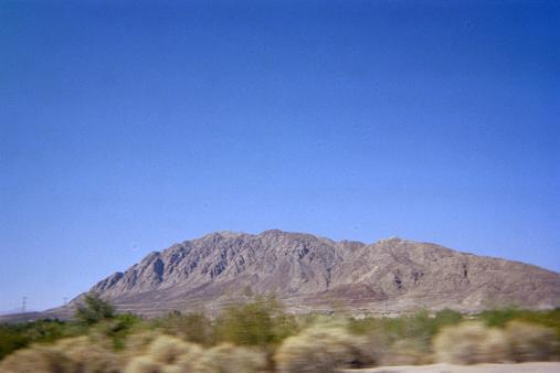
Centinela seen from due east.

The antennae are not at the true summit. We hike on nearly flat ground to the farthest south antennae complex, and then descend perhaps 70 feet to a saddle. From there it is still perhaps 300-400 vertical feet to the true summit along a route with green arrows painted on the rock.

I stop at what appears to be the summit with a metal cross. For this area I obtain (621080 E, 3610182 N) at 2,527 feet (770.2 meters) with an accuracy of 5 or 6 meters.

When Bob arrives he sights with hand level and notes that the area 100 yards south-southwest is a few feet higher. I saunter over there, noting a concrete plaque and a tall, white cross. Both have been placed by Mr. Tiznada who has climbed Centinela over 150 times - the plaque after his 50th summit and the cross after his 100th summit.

Both visual observation and Google Earth suggest that the summit ridge containing these two highest areas lie along an axis wherein every six units of north travel is accompanied by one unit of east travel - a true heading of 010 and 190°. The straight-line distance between these two summit areas is visually estimated as 100 meters. Thus I obtain (621065 E, 3610087 N) for the coordinates of the (very slightly higher) south-southwest area, as 95 meters south and 15 meters west of the north-northeast summit area. I estimate the error in these horizontal coordinates to be ± 20 meters for the northing; and ± 10 meters for the easting.

border xing
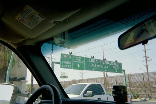
We enter the line for vehicles
crossing from Mexicali to the USA.

I return to my pack and eat "lunch" at roughly 9:30 a.m. It has taken us 3 hours 15 minutes to get here - and it will take nearly an equal amount to return; owing, as with the last climb, to loose rock and scree that demands careful attention at every step. A well-conditioned person should be able to climb the peak in 2 or 2 1/2 hours - and then take an equal amount of time for the descent.

There are two additional 30 foot ascents on the return. Together with the aforementioned 70 foot and 150 foot portions, and a 30 foot drop between the two summit areas, one obtains 2 x (150 + 70 + 30 + 30 + 30) = 620 feet of elevation gain beyond the net gain of 2,527 - 250 = 2,277 feet, i.e. a 2,900 foot total elevation gain.

The border crossing in Mexicali wastes more than an hour - possibly even 1 1/2 hours. We drive west on Interstate-8 and, after hitting the San Diego evening rush hour, arrive at my home around 6:30 p.m.

I have a wonderful dish of three eggs "sunny side-up" with salami, tomato, onion and Spanish Iberico cheese. Bob shares a CDROM with pictures from his recent Colombia trip where he climbed both Ritacuba Blanca and Nevado Ruiz.

The next morning Bob leaves for Palomar Mountain. I receive a phone call from him later that day as he awaits the ascent of Whale Peak - which he is likely descending as I write this very report.