John Hamann, "KR", Adam Helman and Dennis Poulin.
|
Mystery Island Peaks Trip Report © November 2011 Adam Helman |
 is just off the mainland southwest of
Oxnard, California and due west of Los Angeles. It's a haven for Nature, with the eastern one-third occupied by
Channel Islands National Park; and the remainder by
is just off the mainland southwest of
Oxnard, California and due west of Los Angeles. It's a haven for Nature, with the eastern one-third occupied by
Channel Islands National Park; and the remainder by
 - henceforth "tree huggers".
For peakbaggers that means two goals - the national park highpoint El Montañon (1,808 feet),
and the island highpoint
- henceforth "tree huggers".
For peakbaggers that means two goals - the national park highpoint El Montañon (1,808 feet),
and the island highpoint
 (2,475 feet).
El Montañon, on public land, is accessed by a
trail system from Scorpion Harbor and campground. In contrast,
(2,475 feet).
El Montañon, on public land, is accessed by a
trail system from Scorpion Harbor and campground. In contrast,
 (henceforth "DP")
is closed to the public. The main planning task for a peakbagger, therefore, is conjuring a
means of climbing it without notice.
As an island highpoint, DP's prominence equals its elevation, placing it on the California 2,000 foot
prominence list. It is also, remarkably, the Santa Barbara County prominent point.
DP can be climbed legally. However the expense (hiring a private boat) and paperwork
seem excessive. Thereby after a series of E-mail deliberations Bob Packard and I settle for a
stealth assault. We are joined by John Hamann for just DP; and, as a separate contract with the
boat company
(henceforth "DP")
is closed to the public. The main planning task for a peakbagger, therefore, is conjuring a
means of climbing it without notice.
As an island highpoint, DP's prominence equals its elevation, placing it on the California 2,000 foot
prominence list. It is also, remarkably, the Santa Barbara County prominent point.
DP can be climbed legally. However the expense (hiring a private boat) and paperwork
seem excessive. Thereby after a series of E-mail deliberations Bob Packard and I settle for a
stealth assault. We are joined by John Hamann for just DP; and, as a separate contract with the
boat company  (henceforth "IP"), Dennis Poulin and "KR" as well.
Remarkably, each of us comes from a different state - and they are all connected in a giant
"L" as New Mexico, Arizona, California, Oregon and Washington. It will be the November 5-6 weekend,
and yet the outbound boat ride is on Friday the 4th so that I don't have to return through
Los Angeles on a Monday afternoon.
(henceforth "IP"), Dennis Poulin and "KR" as well.
Remarkably, each of us comes from a different state - and they are all connected in a giant
"L" as New Mexico, Arizona, California, Oregon and Washington. It will be the November 5-6 weekend,
and yet the outbound boat ride is on Friday the 4th so that I don't have to return through
Los Angeles on a Monday afternoon.
|
|
|
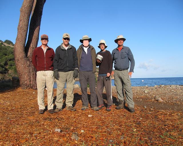
At the beach Sunday morning. From viewer's left - Bob Packard, John Hamann, "KR", Adam Helman and Dennis Poulin. |
|
|
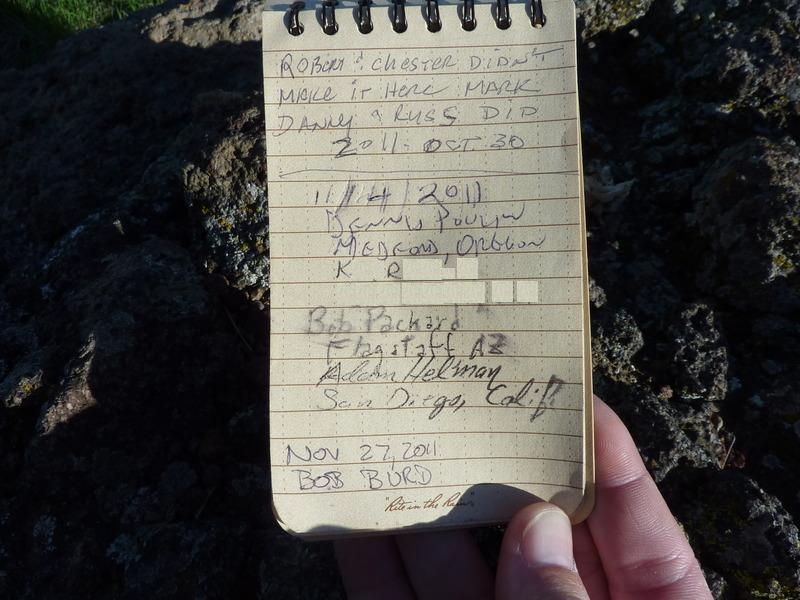
El Montañon summit register after Bob Burd gets there three weeks later. |
 (henceforth "PH") about 30 minutes away.
The ride is even more bouncy than before. Eating a cheeseburger helps because it gives me something
to occupy my mind rather than concentrating on how miserable I feel. We disembark at about 11:30 a.m.,
having reservations for waterless Del Norte Campground tonight.
We never go there, of course, as that's three miles in the wrong direction (east) relative to our goal
of climbing DP.
There are construction workers with heavy equipment just inland from the shore.
There are naturalists with garden plots and intentions of repopulating the immediate habitat with specific species.
Finally (and most disturbing) is a group of tourists led by a tree huggers staff member who are
just beginning a short nature walk onto their private property ... using the same path we intend to start our
climb with!
We store our overnight gear inside a quartet of bear boxes located on the south side of a public bathroom.
I stuff my entire backpack inside as a means of keeping my items organized.
Then we pretend to consult our maps at the start of the road leading to Del Norte. In truth we are deciding
WHAT TO DO about this tour group.
One option is to bushwhack upslope, steep terrain and all, after they depart and never using the gentle
trail they are taking partway to Pelican Harbor. Another option also involves waiting, yet taking the same
convenient trail after they are well-distanced ahead of us - and then divert southwest to
spot elevation 789
when the terrain allows for it. We use this plan, and begin at the most unfortunate time of 12:23 p.m.
As the slowest among us (at age 75!!) I know that Bob can go faster because he is talking.
Time is critical, and he really should be huffing-and-puffing to the point that
conversation is not possible. Later, when night threatens, he gives it his "all" and I have no complaint.
From point 789 we spy an upper, skyline ridge and a lower nearby one.
We need to be on the higher ridge heading for this
1,400 foot contour.
However there's a deep chasm between the two ridges that looks unappealing. We gain the lower ridge
and then enter a rocky gully on it's right (north) with the aim of taking it southwest until the two ridges meet.
This plan, by John H, works until he suddenly and inexplicably decides to divert right, uphill, heading directly
for the desired ridge. Bob and I follow, while Dennis P and KR continue up the gully.
The route is horribly thick with trees and brush, a nightmare of tangled mass that has us covering inches rather
than strides. Finally we "break out" after perhaps 100 vertical feet and continue.
Bob wants to know where we should go - north upslope or sidehill west.
I explain that ultimately we must go west for DP, yet for the moment we should head north to the main ridge.
Dennis and KR are spotted a few hundred yards ahead of us, on a completely different south-trending ridge,
having decided to not follow Bob, John and myself into green hell.
Half an hour later all five of us rendezvous just east of
Red Peak
on the main east-west ridge. It's already about 2:30 and yet only one-third of the distance to DP
has been covered.
The going is rough, considerably slower than anticipated based on our El Montañon experience.
In fact, it's looking doubtful we'll make the summit by dark.
That's potentially serious (although not life-threatening), and each of us
has a personal concept of the chances we will be forced to sleep on the mountain and summit the next morning.
Such a plan would be most unfortunate: owing to predicted high winds tomorrow afternoon (and hence
dangerously rough seas), there's a good chance our boat will
come early, as soon as 9 a.m., rather than for the scheduled 2:45 p.m. departure.
We would miss the boat
and be forced to overnight at PH with meager food rations. However we do have plenty of water thanks to
a 2 gallon bag of water Bob filled at Scorpion Campground.
A complication arises in that Daylight Savings ends tonight at 2 a.m. Synchronization of our timepieces
with IP is important. If we fail to move back watches one hour then our "2:45 p.m."
is their "1:45 p.m." and we are one hour early. However if IP fails to reset their clocks
then their "2:45 p.m." is our "1:45 p.m." and we are one hour late since we will conclude that
we still have one hour for getting to the dock. Thereby I called IP before the trip to verify they are
aware of this time shift.
Generally it is best to remain on the main ridge. However at either
spot elevation 2021 or
this summit
one must sidehill because the far (west) side is extremely steep. We go around the north side,
a mistake, because the brush becomes intolerably thick. I recommend, therefore, trying the south side.
It's now getting dark regardless of time zone. Without direct sunlight the ridgeline wind is suddenly cold
and uninviting. We put on layers, and soon headlamps in preparation for nighttime. We are only inside this
kilometer-square map section,
heading northwest, and still about 1 1/2 "GPS miles" from our goal.
I insist that people stay together so that John's lamp can guide us - he seems to prefer scouting ahead
and then waiting for us. Although that's OK in the daylight when the route is obvious, it's alltogether
insensible under the current conditions.
The two-thirds full moon considerably helps us locate the general path, while headlamps allow us to climb over
rocks and avoid smashing into trees.
The final 400 vertical feet brings an end to any thought of remaining here for the night: for on the far side
of DP is a real trail followed by a dirt road - easy navigation by moonlight.
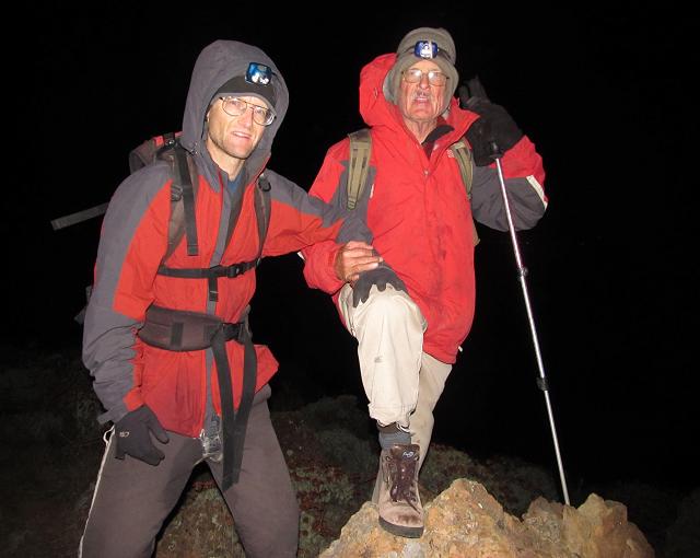
We summit at 8:08 p.m. and huddle on the communications shack leeward side. I quickly enjoy a bagel with
pastrami and habanero Jack cheese. To recognize the nocturnal nature of our success Dennis photographs Bob and myself
at the obviously highest natural rock perhaps five yards east of the shack.
(henceforth "PH") about 30 minutes away.
The ride is even more bouncy than before. Eating a cheeseburger helps because it gives me something
to occupy my mind rather than concentrating on how miserable I feel. We disembark at about 11:30 a.m.,
having reservations for waterless Del Norte Campground tonight.
We never go there, of course, as that's three miles in the wrong direction (east) relative to our goal
of climbing DP.
There are construction workers with heavy equipment just inland from the shore.
There are naturalists with garden plots and intentions of repopulating the immediate habitat with specific species.
Finally (and most disturbing) is a group of tourists led by a tree huggers staff member who are
just beginning a short nature walk onto their private property ... using the same path we intend to start our
climb with!
We store our overnight gear inside a quartet of bear boxes located on the south side of a public bathroom.
I stuff my entire backpack inside as a means of keeping my items organized.
Then we pretend to consult our maps at the start of the road leading to Del Norte. In truth we are deciding
WHAT TO DO about this tour group.
One option is to bushwhack upslope, steep terrain and all, after they depart and never using the gentle
trail they are taking partway to Pelican Harbor. Another option also involves waiting, yet taking the same
convenient trail after they are well-distanced ahead of us - and then divert southwest to
spot elevation 789
when the terrain allows for it. We use this plan, and begin at the most unfortunate time of 12:23 p.m.
As the slowest among us (at age 75!!) I know that Bob can go faster because he is talking.
Time is critical, and he really should be huffing-and-puffing to the point that
conversation is not possible. Later, when night threatens, he gives it his "all" and I have no complaint.
From point 789 we spy an upper, skyline ridge and a lower nearby one.
We need to be on the higher ridge heading for this
1,400 foot contour.
However there's a deep chasm between the two ridges that looks unappealing. We gain the lower ridge
and then enter a rocky gully on it's right (north) with the aim of taking it southwest until the two ridges meet.
This plan, by John H, works until he suddenly and inexplicably decides to divert right, uphill, heading directly
for the desired ridge. Bob and I follow, while Dennis P and KR continue up the gully.
The route is horribly thick with trees and brush, a nightmare of tangled mass that has us covering inches rather
than strides. Finally we "break out" after perhaps 100 vertical feet and continue.
Bob wants to know where we should go - north upslope or sidehill west.
I explain that ultimately we must go west for DP, yet for the moment we should head north to the main ridge.
Dennis and KR are spotted a few hundred yards ahead of us, on a completely different south-trending ridge,
having decided to not follow Bob, John and myself into green hell.
Half an hour later all five of us rendezvous just east of
Red Peak
on the main east-west ridge. It's already about 2:30 and yet only one-third of the distance to DP
has been covered.
The going is rough, considerably slower than anticipated based on our El Montañon experience.
In fact, it's looking doubtful we'll make the summit by dark.
That's potentially serious (although not life-threatening), and each of us
has a personal concept of the chances we will be forced to sleep on the mountain and summit the next morning.
Such a plan would be most unfortunate: owing to predicted high winds tomorrow afternoon (and hence
dangerously rough seas), there's a good chance our boat will
come early, as soon as 9 a.m., rather than for the scheduled 2:45 p.m. departure.
We would miss the boat
and be forced to overnight at PH with meager food rations. However we do have plenty of water thanks to
a 2 gallon bag of water Bob filled at Scorpion Campground.
A complication arises in that Daylight Savings ends tonight at 2 a.m. Synchronization of our timepieces
with IP is important. If we fail to move back watches one hour then our "2:45 p.m."
is their "1:45 p.m." and we are one hour early. However if IP fails to reset their clocks
then their "2:45 p.m." is our "1:45 p.m." and we are one hour late since we will conclude that
we still have one hour for getting to the dock. Thereby I called IP before the trip to verify they are
aware of this time shift.
Generally it is best to remain on the main ridge. However at either
spot elevation 2021 or
this summit
one must sidehill because the far (west) side is extremely steep. We go around the north side,
a mistake, because the brush becomes intolerably thick. I recommend, therefore, trying the south side.
It's now getting dark regardless of time zone. Without direct sunlight the ridgeline wind is suddenly cold
and uninviting. We put on layers, and soon headlamps in preparation for nighttime. We are only inside this
kilometer-square map section,
heading northwest, and still about 1 1/2 "GPS miles" from our goal.
I insist that people stay together so that John's lamp can guide us - he seems to prefer scouting ahead
and then waiting for us. Although that's OK in the daylight when the route is obvious, it's alltogether
insensible under the current conditions.
The two-thirds full moon considerably helps us locate the general path, while headlamps allow us to climb over
rocks and avoid smashing into trees.
The final 400 vertical feet brings an end to any thought of remaining here for the night: for on the far side
of DP is a real trail followed by a dirt road - easy navigation by moonlight.
We summit at 8:08 p.m. and huddle on the communications shack leeward side. I quickly enjoy a bagel with
pastrami and habanero Jack cheese. To recognize the nocturnal nature of our success Dennis photographs Bob and myself
at the obviously highest natural rock perhaps five yards east of the shack.
|
|
Strong wind makes Adam lean on Bob while at the island's highest rock. |