Nevada Ultra Prominences September 2007 Trip Report
© September 2007 Adam Helman

Note 1: All GPS-derived UTM coordinates use the NAD27 datum.
Note 2: Click on any image for enlargement.

Background

Edward Earl and I have long contemplated "cleaning up" the four Nevada ultra prominence summits that remained on our plate because they are not also county highpoints. In 2006 I was burned-out by September from a summer's worth of climbing; and Edward had alternative, equally attractive venues such as a New Mexico state completion.

Then, in late April 2007 we climbed Hayford Peak with fellow San Diegan Gail Hanna.

The entire journey is limited to nine days by Edward's work, as two weekends with the five workdays sandwiched between. Edward was not available the first Saturday, and so the journey lasts eight days. The first and last days are for driving, leaving six days and thus six peaks to scale. With three ultra prominence summits remaining, time is available for making a dent into the extensive list of Nevada peaks with over 4,000 feet of prominence. Indeed, Nevada has 24 mountains meeting this criterion - more than any other state, by far, in the contiguous forty-eight states.

I only wish to climb the ultras, plus a "near-ultra", as Mount Moriah, with a prominence range that just barely straddles the 1,500 meters (4,921 feet) international cutoff definition. Thus I am quite interested in Arc Dome, North Schell Peak, Pilot Peak - and Mount Moriah.

To this list Edward adds Hole-in-the-Mountain Peak on the USA Top 100 list (with a prominence of 4,849 feet); and Mount Lewis, a drive-up and the Lander County prominent point with 4,290 feet of the stuff. Most unfortunately these six summits are located such that Pilot Peak and Hole-in-the-Mountain Peak are climbed on back-to-back days. As each entails nearly 5,000 feet of elevation gain this is a tiring proposition. Were I to have gone alone, and without work constraints, I would have placed a rest day between these two venues. As-is, I choose to sit at the car while Edward hikes Hole-in-the-Mountain - a summit that I never really want to climb anyway. Perhaps someday I'll get interested in the USA Top 100 list ... but not today.

We drive my Toyota Tacoma because it has the desirable features of four-wheel drive and high clearance. It has never failed to perform adequately regardless of the venue.

Diarrhoea plagues me from Mount Moriah through Pilot Peak. The worst case of my life, it is highly inconvenient, pervasive, and disgusting. With water rushing freely out the "wrong end", I am hard-pressed to remain hydrated for climbing as I am afraid to drink water - especially at night lest I dress madly, exit the camper, and rush for the trees in cold and dark. Further, gas bloats my stomach the instant I eat anything, no matter how small. The enjoyment of being outdoors, and particularly at camp in the late afternoon, is destroyed by this ailment. Most peakbaggers would not climb under these conditions.

Trip Details

Sunday, September 16 - to eastern Nevada

Interstate 15 followed by US Highway 93 gets one to the Great Basin, our first venue being Mount Moriah just north of US Highway 50 and east of Ely, Nevada.

The final approach drive is steep for some 3-4 miles, with the vehicle in "4-LOW" as it gains elevation quite rapidly - remarkably so. In fact, this is the first time I use 4-LOW in the five years I've owned the truck. This is not because our road is the steepest encountered; rather, I wish to take this as a prime opportunity to "experiment" with this powerful feature.

Upon stopping for the day, my trip "B" odometer indicates 9.5 miles from the "main" dirt approach road; the latter having been taken for some 12.5 miles north after leaving US Highway 50 east of its junction with US 93 at Major Corners.

The "A" odometer is zeroed at journey's start and in general does not get reset until returning home - so providing the grand total driving distance; while allowing me to compute how much Edward will owe me for gasoline based on a mean of 21 miles per gallon.

I feel justified with my insistence in leaving Edward's apartment no later than 7 a.m. - for after some 620 road miles we arrive with only enough time to make supper before darkness. The elevation is 9,600 feet.

Our habit after darkness is to sit in the truck cab, reclined if desired, and talk about the world of prominence and climbing - often with a highly mathematical/technical flavor. My prominence book, The Finest Peaks, commonly serves as reference - and Edward brings his copy with that express intent. New concepts are tossed about by Edward, and I serve as a sounding board with high-flying comments and practical considerations.

Monday, September 17 - Mount Moriah

This would have been a thoroughly enjoyable effort apart from two items - a mending leg sprain, of unknown origin; plus the stomach upset with diarrhoea that only worsens.

The former makes for painful downhill travel, and is partly relieved by one Motrin tablet at the summit. On subsequent climbs I would also use a knee bandage - and the combination proves good enough to make the pain barely perceptible. By Arc Dome I require neither form of aid, the sprain presumably having healed.

Mount Moriah
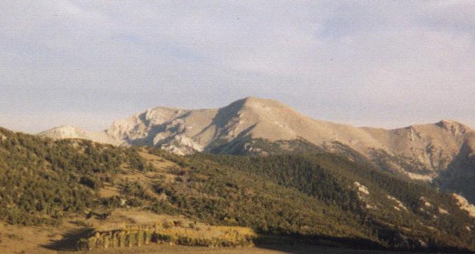
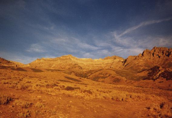
Mount Moriah is the central peak.
The morning sun hides behind a veil of clouds, and our summit break proves chilly from wind. It is not exactly how one envisions a summertime effort, and we depart after 20 minutes for want of better conditions.

At the summit I enjoy a blueberry Pop Tart spread with cheddar cheese.

The round-trip lasts some 4 hours 15 minutes, and, being not even noon, we liesurely drive down the mountain range and into Ely for some errands. My front left headlight has finally fallen nearly completely off, dangling precariously by two thin wires. Duct tape from a hardware store mends the matter; we fill the tank with gas; and, after some hot chocolate with snack we drive north all of some 20 miles on US 93 to the turnoff for North Schell Peak. Edward buys a one pound bag of pepper beef jerky - his favorite flavor.

We arrive around 3 p.m. to our 8,600 foot camp in an official National Forest campground, paying $8 for the privilege to eat on a table, fill our water containers, and, even though it is a nine minute walk, use the bathroom.

Edward eats
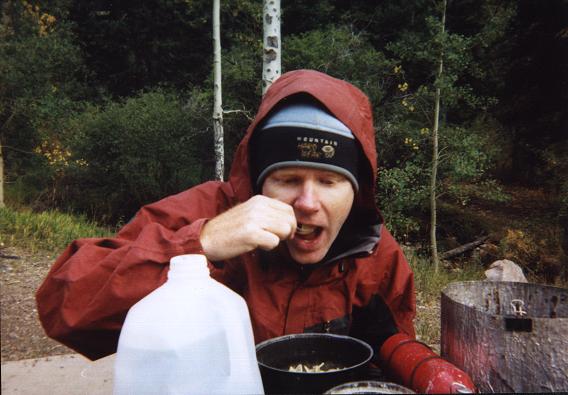
Edward enjoying chicken noodle soup
the afternoon before North Schell Peak.
After supper Edward and I walk to the outhouse with the goal of finding its resonant frequencies by humming at progressively higher pitch until discovering peculiarly sonorous and loud echoes - resonance. This surely sounds bizarre to nearby folks gathering wood!

Tuesday, September 18 - North Schell Peak

I awaken to a mild headache - the combined result of modest altitude and dehydration caused by refusing to drink water (to avoid inciting diarrhoea). Quickly, I chug a pint of water and take an Imodium tablet purchased in Ely. Not quite as cold as yesterday morning (we are 1,000 feet lower), I nonetheless wisen-up and eat my Raisin Bran with much milk inside the camper shell rather than on the tailgate as yesterday. Indeed, it was cold enough before Moriah that yesterday's Fruit Loops, even adorned with cashews and brazil nuts, was not really fun to eat.

After over a quart of fluid I join Edward for the climb - one that begins on a jeep road closed to the public by the Forest Service with numerous tree branches and boulders. The road is left free of debris only for a portion wide enough to admit of single-file foot traffic.

At road's end we travel cross-country, generally southeast, towards the summit. We are now above timberline and the wind picks up. We don extra layers and continue under somewhat windy conditions to the summit. There we hunker down under the ridge for a remarkably wind-free summit siesta. I warm my half-numbed fingertips with thin, black rocks that absorb and retain the sun's rays. A pint of fruit cocktail is shared with Edward - a cool and refreshing treat planned for a warm day. Under the current conditions it is not the most appropriate snack: hot cocoa would have been better!

The descent is rapid and uneventful apart from my internal plumbing issue.

It is two hours drive along US Alt 93 to Wendover, Utah near Pilot Peak. Pilot Peak looms ever-larger in our sights, a truly massive mountain that is a most impressive freestanding summit. We depart the "main" dirt road and travel 5.7 miles along a jeep track to our 5,800 foot campsite some 3 miles south and one-half mile east of the summit.

Edward and salt flats
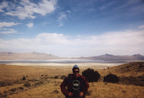
View southeast to Utah salt flats
from our camp beneath Pilot Peak;
Edward in foreground.
We are all-too-aware of Pilot's reputation for nasty, prolonged scree and talus, and desire to avoid much of that if possible. From the truck cab we spy a route that might indeed lower the angst, and agree to follow it the next day.

After finishing my food in thankless fashion (it is a challenge owing to severe GI problems), Edward and I retreat to the truck cab for our standard round of discussion.

Wednesday, September 19 - Pilot Peak

The route Edward and I climb is of considerable merit to future efforts, avoiding the most egregious talus and scree slopes. It is not entirely free of these issues. That said, anybody using our route will find it hardly any more annoying than any of dozens of other peaks where scree-slogging is considered de rigeur.

On return to my truck we locate a shorter, alternative jeep track that reaches the main gravel approach road quicker and with less driving issues. The following mileages are based on the reverse road log we compile, and accounts for the fact that my truck's odometer reads one-sixtieth part low.

0.0   Zero odometer at intersection of I-80 Exit 4 freeway ramps by Sinclair station.
1.2   Turn left.
4.4   A gravel side road goes straight ahead; stay on main road as it angles left.
7.5   The pavement ends at the Nevada / Utah state line. Enter Nevada (unpaved).

16.9  
Rocky, jeep road turnoff just before a cattle guard at the state line.
          Junction coordinates are (749042 E, 4536344 N) at 4,383 feet.

From that turnoff it is 3.7 miles to our camp at (746555 E, 4540978 N), elevation 5,837 feet.

For the ascent we walk the jeep road some 850 vertical feet to the "M" of "Miners" with coordinates (745339 E, 4542182 N) at 6,679 feet. Exit the road by turning right, and climb steeply up a grassy slope, with some rockhopping, for some 300 vertical feet. This gains a side ridge which is taken to a key waypoint - lightly colored rocks at (744971 E, 4543114 N), elevation 8,387 feet. On our ascent and prior to achieving this location we rest at (745014 E, 4542786 N), elevation 7,796 feet.

Pilot Peak
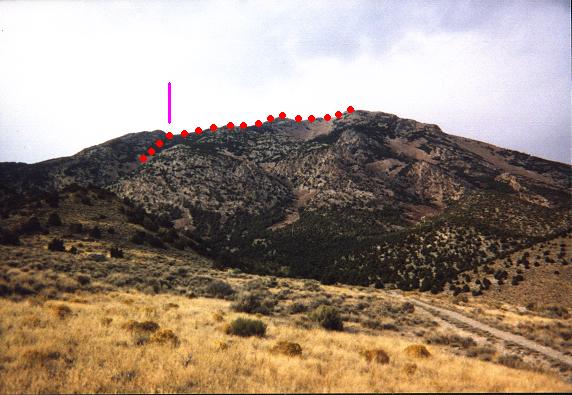
The upper route for Pilot Peak.
Gain the skyline ridge at the violet line.
The mountain is FAR larger than it appears.
At the aforementioned rocks, change heading and leave the side ridge bound for the main, summit ridge at the northern base of a prominent, skyline rock mass (point 9,113 feet). We break just under the summit ridge, due to wind, at (745048 E, 4543586 N), elevation 9,002 feet. This portion entails bushwhacking over large talus and through brush - yet the talus is no worse than one encounters elsewhere.

Now on the summit ridge and with 1,700 vertical feet remaining, the route shallows somewhat until near subpeak 10,182 feet. Ascend this feature, possibly contouring clockwise around its back (northern) side, so reaching the north side of a series of rocky outcrops which lead in the desired direction.

We ascend the rocky outcrops to avoid nasty talus, yet ultimately descend south, back onto talus, in order to avoid getting "cliffed-out" at the eastern terminus of these outcrops. Talus is climbed to the summit, the slope diminishing for the final push.

Our summit siesta lasts 50 minutes, and is highlighted by naps in a large windbreak some twenty feet south of the summit register - a mailbox stuffed with notes and such. I enjoy a cherry Pop Tart with Kraft "Roka Blue" cheese spread.

On descent we upclimb the Class 4 rock, solid, that proved too daunting on ascent (as it would have to be downclimbed), and located at the eastern terminus of the second most easterly rock outcrop. The first outcrop, a gendarme, is disconnected from the main rock ridge and should be avoided. This gets us back on solid rock, which we re-traverse to point 10,182 feet. We then return the route of ascent.

Hole-in-the-Mountain
Hole-in-the-Mountain Peak at sunrise.
Back in Wendover I am dismayed to not find a pint of ice cream - my habitual treat for a successful ascent with at least 4,000 feet of elevation gain. I settle for a trio of ice cream novelties - including a Snicker's Brownie ice cream sandwich and the like. Edward drives us to Elko along Interstate 80 as I am gainfully occupied eating these treats.

I take over driving and, after dark-induced navigational problems, locate the approach road for tomorrow's venue. We camp in a huge flat area and sleep soon after.

Thursday, September 20 - Hole-in-the-Mountain Peak

I never intended to climb this mountain. Nor did I savor the idea of back-to-back near 5,000 foot gain days - generally a tiring proposition. Yet the road grid suggests this itinerary. Were Edward to not work he likely would have elected a rest day in-between. As-is I lounge around the truck, reading National Geographic and eating plenty of food without worry of the consequences.

Edward returns from the climb in just under eight hours, one that some day I'll do because Hole-in-the-Mountain Peak is on the USA Top 100 prominence list. We drive west to Elko (in Elko County) for a motel room. In Nevada rooms are quite cheap as they are subsidized by the gambling industry. Edward attends a Chinese buffet while I eat fresh pasta salad and marinated vegetables in the room.

Mount Lewis approach
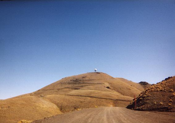
The final few miles of the approach road
zigzags to the summit of Mount Lewis
Note the large radome.
A half-gallon of milk is shared (there's a room 'fridge) as we watch a pair of hour-length television programs. Edward gets the lion's share as-is his way with milk. I have a chocolate-iced "long-john" doughnut with it, as I refuse to drink milk for its own sake: where's the flavor??. Indeed, in my opinion, milk is simply an adjunct that enhances enjoyment of breakfast cereal, dessert or other solid food.

We learn from the Weather Channel that rainshowers are forecast for Saturday.

Friday, September 21 - Mount Lewis

We eat breakfast in the hotel restaurant, Edward enjoying large buttermilk pancakes with a side-order of scrambled eggs; myself peach pie and milk plus the same protein allotment. I did not relish the idea of a full breakfast - it would make be drowsy when I have to drive many-a-mile. So the chicken-fried steak would wait for another day. Plus, I love pies of all variety.

This drive-up is located just south of Battle Mountain along Interstate 80, and is the Lander County prominence point. Edward earlizes it, as is his practice; while I drive to a saddle between the two main peaks. From there it is some 100 feet of gain ("helmanizing") to the slightly higher, east summit. The west summit features an enormous spherical radome and other electronic gear.

Mount Lewis summit
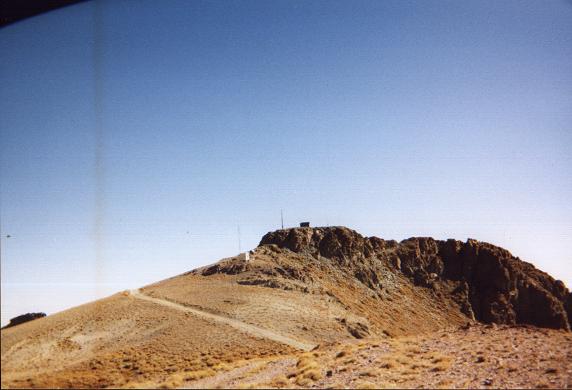
The true summit of Mount Lewis
seen from the saddle connecting it
with the radome's false summit.
We proceed south to Austin, near state's center and along US Highway 50; and then farther south under increasingly threatening skies to a campground, elevation 8,540 feet, 9.5 road miles southeast of the main, gravel approach road.

It begins drizzling around 8 p.m., and continues basically unabated through the night until perhaps 5 a.m. Tomorrow's prospects don't appear promising.

Saturday, September 22 - Arc Dome and Berlin-Ichthyosaur State Park

KKOH (780 KHz, Reno) claims last night that Sunday's weather will be no better, a second band of rain passing through the region in short order. Further, waiting one day means an extremely hectic schedule wherein we drive home that very evening, after climbing the peak, arriving perhaps 1 or 2 a.m. to San Diego just so Edward gets to work on-time.

Is that snow on a distant hill? We cannot say for sure. What is certain is that clouds continue to obscure the eastern sky, and, even if it represents just orographic lifting and not a continuing storm front, the clouds suggest threatening weather the entire day.

We start at 9:30 a.m., hoping that maybe, just maybe, things will be "O.K." They are not - and far from it. After one hour we hit snow on-trail, and, after two hours and at a 10,600 foot saddle, we are trudging through eight inches of fresh powder. The going is too slow, the hour too late, to reach the summit and return before nightfall. Further, Edward has only blue jeans - inadequate attire for walking in fresh snow.

We turn back, but not before ascending an unnamed, nearby hill to the northeast - point 10,842 feet. Sure, we could have pushed on, but the going would have been miserable - and especially after night fell. It is simply not reasonable to start at 9:30 and climb 4,800 vertical feet (net gain: 3,200 feet) while postholing most of the time, over several miles of trail-less terrain (the trail is now buried in snow), with the goal of returning by sundown. Snowshoes would have been of great value - but who packs that gear for what's supposed to be a summertime hike?

ichthyosaur
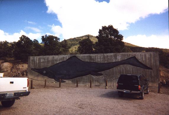
Life-size rendering of an
ichthyosaur dwarfs my truck.
We dismantle my tent, in which Edward slept; and drive by 1:30 p.m. Another concern is that Reno radio says that the snowline could drop in nearby Mono County to 7,500 feet - and that could lock us into camp until it melts. This is another reason why I declined to make a re-attempt the next day.

We visit nearby Berlin-Ichthyosaur State Park. Giant, fish-like reptiles inhabited ancient seas 180 million years ago - the ichthyosaurs. Indoor exhibits describe and celebrate their existance through the fossil record. Berlin is an abandoned silver mine, and the Park has several wooden buildings with mining equipment and explanation.

We return to California via Gabb, Nevada - thence Route 95, and finally Route 6 into Bishop in the Owens Valley. At the Pizza Factory we split a large, ten-slice pizza. Edward's half is with italian sausage; mine is with spinach and garlic. GOSH it's good! From the salad bar I enjoy many items, and some of them are saved as toppings that I know will pair well with the spinach / garlic pizza - crumbled bacon, sunflower seeds, olives.

By dark and in the pouring rain I drive about 100 miles south to a turnoff for Red Hill - a roadside cinder cone that we've known for over ten years and "saved" to climb for when a primary goal turns sour. With failure at Arc Dome the time is ripe.

Sunday, September 23 - Red Hill and Return

The truck parked perhaps one-half mile south of it, we arise and hike Red Hill shortly after dawn with some 600 feet of elevation gain. After contouring around the west slopes, slowly gaining elevation, we take a shallow ridge that proceeds south to the highest point.

Summit views are wonderful, and include melting snow on Olancha Peak to the north. A large mining operation is below and to our southeast at the hill's base.

On returning we simply descend, and rapidly so, west to the base and the awaiting power line service road. Edward descends at some 5,000 feet per hour, myself slower to maintain "control" of each step in the red cinders.

Red Hill
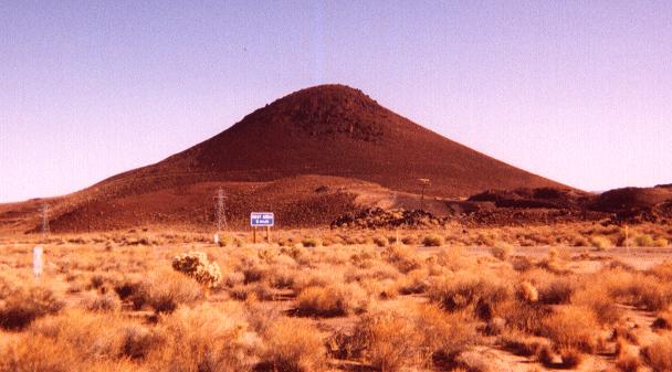
Red Hill along US Highway 395
viewed from the southwest.
Tall electricity towers provide scale.
With plenty of time (it is only 9 a.m.) Edward likes my idea of stopping to eat in Ridgecrest. There he gets pancakes at McDonald's; and, with Edward driving, I enjoy the venta ("large") size Starbuck's Java Chip Frappuccino - most decadent item on the menu. I agree to the "light" variety (Splenda replacing sugar) just to "be different"; and also request that the topmost dome of whipped cream be replaced with simply more iced drink.

The result is a mammoth chocolately confection, perhaps a pint and one-half, that I enjoy as much these days as a pint of ice cream. Admittedly, I did not "earn" this treat with Red Hill or Arc Dome - but, hey, one has to "eat" anyway 8-).

The drive home is uneventful, and Edward is deposited at his apartment by early afternoon. Upon reaching my home 9.4 miles later, the truck odometer indicates a 1,828 mile journey.

Summary

Pilot Peak's new route is a trip highlight. It is my hope that our suggested climbing route be considered seriously by future peakbaggers.

Somehow I managed to climb the peaks on my wishlist despite a debilitating intestinal problem. Again, I distuinguish between mere inconvenience, admittedly large in my case, with nixing a summit bid owing to outright danger.

I am sorely disappointed in having been caught by the season's first winter storm at Arc Dome. We are intensely unlucky in this regard, as it is quite rare for a winter storm to hit the southwest in September - indeed, on the last full day of "summer".

My intention for several months was to have at least 70 ultra prominence summits by year's end. Now, with failures on both Mount Olympus and Arc Dome, that goals seems remote indeed since, at a count of 68, I now need at least two ultra summits by December 31 ... and these peaks don't grow on trees!

Furthermore, nabbing all three ultra summits would have secured an impressive 804 statue mile ultra prominence glob radius, i.e. the distance from my home to the nearest unclimbed ultra summit (Diamond Peak, Idaho). As it stands, my radius is limited by Arc Dome to a paltry 406 miles.

Edward Earl now has three more ultra summits to complete the 57 peak list of contiguous states ultra prominences (McDonald Peak, Snowshoe Peak (both in Montana), and now, additionally, Arc Dome). I have 44 of these 57 summits - and I honestly feel that figure should have been "45" were it not for that freak snowstorm.

It is possible to climb Arc Dome as a winter ascent. More arduous and certainly of greater duration than a summer's dayhike, this remains a possibility. More likely, though, Arc Dome will await next summer as the first (or last) peak of a lengthy climbing trip: at 530 road miles, it is but a single day's drive from my San Diego home.