Elevation : 8648 feet Prominence: 5023 feet Location : 51:26.2 N – 119:57.3 W Backroads Mapbook: Kamloops/Okanagan (3rd edition), Map 50:G1
Not all roads are shown as Dunn is near the edge of the territory it covers.
There is likely an updated mapbook that covers this area in greater detail. Climb Duration: Dunn could be climbed in one very long day but we camped two nights
at the valley's head with a short approach/hike out and a day in between for the climb.
The approach took us about 3 hours at a relatively leisurely pace. Elevation gain : about 4,000 feet Difficulty: Class 3+ with maybe a few Class 4 moves. Others in Party: Andrew Strand, Grant Myers. Climbed September 16, 2012.
Overview
This relatively unknown gem is located a few hours north of Kamloops B.C.
Although a trail leads into the valley, the area does not appear to see a lot of visitors
probably due to its distance from any major population center.
A surprisingly pleasant and straightforward approach leads through beautiful meadows along the
scenic Joseph Creek valley.
Our ascent in mid-September took advantage of a good late season weather window with the
added benefit that bugs were almost nonexistent. The lush meadows and ponds suggest
the mosquitoes could be a major nuisance here earlier in the season.
The scrambling was steep in places but not really technical. Views from the summit include
Pukeashun to the southeast, Trophy Mtn and Wells Gray Park to the north and the glaciated peaks
of the Monashee Range to the East.
Grant Myers’ beautiful photographs and description are
posted on Shutterfly.
Other reports can be found on the ClubTread website - a good resource for southern
British Columbia reports. Use the “search” tab on the home page's
right hand side to locate trip reports.
Since Grant’s report and photos of the actual climb are quite complete, only a few additional
details regarding the drive and hiking approach to camp are included.
Driving Instructions
Starting from the intersection of Highway 5 in downtown Barriere, follow the paved Barriere Lakes
Road the pavement's end and the junction with North Barriere Lakes Forest Service Road.
Turn left (north) and travel about 10 km on this high speed gravel road to the signed Harper Ck FSR.
Turn left and follow this road, which is in fair condition after the first few km of rough spots
and water bars, for approximately 17 km.
Here there is a junction. Take the left branch and follow it
a short distance to another junction and the signed Dunn Peak FSR.
Turn left onto the Dunn Peak road which is narrower and rougher, although a vehicle with moderate
clearance will get one within a half kilometer of the trailhead. Only a high-clearance 4WD
will make the entire distance of 4 miles due to a particularly rough bit about a quarter mile
from the trailhead. A turnaround at the trailhead
is quite suitable for camping if desired.
Approach
A trail exits the turnaround's left side with a sign posted on a tree about 10 meters in.
From here it is about a mile to the signed park boundary.
Not far beyond the trail crosses
a low wooded saddle before dropping to a swampy meadow.
Cross the meadow and find the trail
on the far side where it reenters the woods and heads up the Joseph Creek valley,
eventually reaching a campsite at the edge of a shallow pond.
Although this is a decent site,
better camping is available a couple of miles farther up the
valley beside the stream with good views of Dunn
at about 6000 feet just over 4 miles from the car.
Route
The route continues up-valley wrapping around the peak's north side through
boulder fields and talus,
eventually reaching the peak's NW ridge/shoulder at 2,320+ meters (~7620 feet). Here the route steepens,
generally staying on or near the ridge crest
on its south (right-hand) side.
Scramble up and over the false summit (2,600+ meters)
and descend an obvious gully to a col
between the two peaks. Another short steep Class 3 section leads to easier terrain above
and the broad flat summit.
Photos0001: grassy turnaround area and start of trail
0003: Dunn Peak provincial park boundary
0005: Meadow crossing, trail resumes in trees on the frame's left edge.
0008: first decent campsite
0013: More meadows in the Joseph Creek valley.
0021: camp at 6000 feet
0025: Dunn Peak from near camp
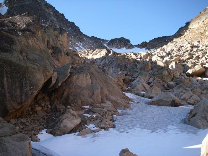
0032: Looking up to the NW shoulder's 7,600+ foot ridgeline from the upper boulder fields.
0049: summit
0052: view of false summit from below the true summit
0053: Looking up-gully descending from the false summit's top.
0054: a short exposed section on the NW ridgeline
Boulder fields and talus looking up to the northwest shoulder's 7,600+ foot ridgeline.