Mount Odin
- by John Stolk
Elevation: 9744 feet
Prominence: 7900 feet
Location: 50:33.1 N 118:07.8 W
Backroads Mapbook: Kootenays, Map #23:E5
Climb Duration: 5-6 days.
Difficulty: Class 2+, Wilderness, low angle glacier travel.
Additional Resources: Trip reports at bivouac.com
Description: Mount Odin is located in a remote region between Monashee Provincial Park
and Upper Arrow Lake in the heart of south-central British Columbia.
This route passes through wild and stunning scenery and offers an opportunity
for an extended wilderness journey to a very prominent summit.
The route is not technical but requires good navigational skills and involves
considerable cross-country travel.
Note: Excellent trip reports with GPS waypoints can be found at Robin Tivy’s
Canadian mountain website so this page will not rehash route information in detail.
Anyone seriously considering this route should make use of these.
Although this page will include a very brief overview of the route the main emphasis
will be on providing additional photographs to give potentially interested parties
an idea of the superlative experience that awaits.
Driving Instructions: From the town of Vernon BC head east on Hwy 6 for +/-30 miles
to the Sugar Lake Rd which heads northeast towards Sugar Lake in the vicinity
of Cherryville. Turn left on the Sugar Lake Rd which is paved at first,
turning to dirt a few miles before reaching a dam at the head of the lake.
Distance to the dam is probably about 10 miles. From the head of the lake turn left
onto the North Shuswap FSR heading around the west end of the reservoir.
Continue past the north end of Sugar Lake and look for a road heading to the right
about 5 miles beyond. This road crosses the Shuswap River and then turns south
paralleling the river. I recall seeing signs for Monashee Park starting in this area.
After several miles reach Spectrum Creek and turn east (left) onto the Sugar Spectrum Road
and follow it approximately 6 miles to the parking area and trailhead.
Route Overview
Part 1: Parking Lot to Peters Lake
A signed trail
leaving the parking area
reaches Spectrum Lake in 6 km.
Good campsites complete with tent platforms,
fire pits (split wood provided on site)
and even a canoe for use on the lake! Beyond Spectrum Lake (between the 7-11 km signs)
the trail becomes much steeper reaching
Little Peters Lake and then
Peters Lake at about 12 km.
Peters Lake also has tent platforms and metal boxes for food storage.
A good potential one-day side trip to prominent
Mount Fosthall can be made from here.
The easiest way to the summit from Peters Lake is reported to be an easy on the
south side although I have no personal knowledge of the route.
Other peaks in the area include Slate
and Cariboo.
Part 2: Peters Lake to Gates Ledges
Leave the southern end of Peters Lake
heading southeast up the shallow draw toward
Margie Lake. At a large open meadow look for a
signpost pointing toward Fawn Lake
and the Gates Ledges. Head generally north and uphill through lightly timbered
and then open alpine meadows to Fawn Lake.
Beautiful camping opportunities abound here.
From Fawn Lake head across the Valley of the Moon
and traverse generally eastward to the top of the Gates Ledges. Finding the entry into the
steep gully leading down
from Gates Ledges to the valley below is the crux of the route in my opinion.
Part 3: Gates Ledges to “Silvertip” Lake at 6700 feet
From the top of Gates Ledges an
overview of the route ahead can be surveyed.
The general idea is to end up on top of the far (east) side of the large Ledge Creek
drainage ahead of you. This entails
dropping down the brushy gully to a point
where it is possible to traverse out to the left (north) to reach
a small bench
running parallel to the main valley.
Follow this bench uphill and north to a
knoll at ~6900 feet
and then descend about 700 feet to
Ledge Lake with a
muddy flat at its north end.
Continue traversing around the head of Ledge Creek in a sweeping rightward direction
reaching another small lake
at ~5700 feet in elevation. From here make an
ascending southeasterly traverse
to the “Silvertip” lake (elev. 6700) .
This section contains quite a bit of bush-whacking and will take about an hour or two
to negotiate. Just below “Silvertip” lake the route gets steeper underneath
a small cliff band but the terrain should not exceed steep Class 2 if you follow
the easiest line.
Part 4: Lake 6700 to summit
This portion of the journey is spectacular and in my opinion the highlight of the route.
From Silvertip Lake
traverse open slab terrain
eastward for about 2 miles to an obvious col east of Mount Odin.
Along the way you will may see
interesting chocolate-swirl patterns in the bedrock.
Ascend to the col and drop down into the depression on the other side, onto the
low angled glacier north of the col.
From here, turn left (west) and
ascend the glacier at its lowest angle
towards the summit.
If conditions are icy, a pair of lightweight instep crampons may be useful.
Although portions of the glacier are deeply crevassed
a rope may not be necessary in late season when much of the overlaying snow is gone.
The final portion of the climb
is along a Class 2 rock ridge.
Enjoy this wild and scenic summit!
Photos (taken September 2006):
0752: Parking Lot.
0753: Trailhead
0754: Beginning of the trail.
0759: Brook crossing along the way to Spectrum Lake.
0763: Camp at Spectrum Lake.
0766: Camp at Spectrum Lake.
0768: Spectrum Lake. Haze from nearby forest fires.
0769: Signed junction to Peters Lake.
0773: Arriving at Little Peters Lake.
0771: Slate Peak
0861: Campsite at Peters Lake.
0862: Peters Lake.
0776: Route leaving Peters Lake up the draw.
0778: Signed junction for Fawn Lake at the large meadow entrance.
0860: View back to Mount Fosthall.
0780,
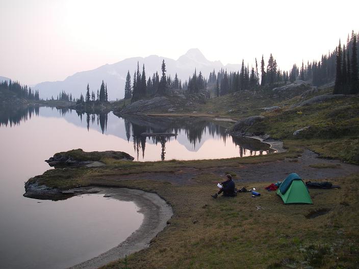
0859: Fawn Lake
0782: View across the Valley of the moon toward the top Gates Ledges
(on the skyline in the background).
0857: View from the top of Gates Ledges across the Ledge Creek valley basin.
Mount Odin is in the clouds (center right) and the high col leading
to the summit is the low point on the far right of the frame.
0785: Top of the gully leading down off Gates Ledge.
0856: View down the gully.
0784: View from gully vicinity to the bench. The goal is to reach the flat grassy area.
Although this portion of the route is steep vegetation provides handholds.
0787,
0788,
0789: Proceeding along the bench.
0791: Approaching the knoll.
0792: Mudflat containing bear tracks.
0793: Bear tracks.
0794: The lake below and right of the knoll.
0796: Small lake at the start of the ascending traverse leading up to Lake 6700.
0798: View from beginning of the ascending traverse (left side of frame)
0799: Creek leading out of Lake 6700 with Odin in the background.
0801,
0804: Views from Lake 6700
0805: Views from Lake 6700 with Odin in the background.
0806,
0807,
0809,
0810,
0814: Views from Lake 6700
0816: Beginning the traverse from Lake 6700 to the col.
0817: View of Bearpaw Lake below the beginning of the traverse to the col.
0818: The traverse looking toward the col.
0819,
0820,
0821: Along the traverse.
0822: View back down toward Lake 6700 (just visible in the center) across the traverse.
0845: View back down toward Lake 6700 (far left of frame) across the traverse.
0847: Similar to 0845 with the Gates Ledge area behind the lake in the
middle distance and Mount Fosthall visible in the far left background.
0825: Looking toward the glacier from the col.
0827: The small depression in the glacier. Our route followed this depression for a
short distance to the north before heading up the low angle snow/ice slope to the left.
0829,
0830: Heading up the snow slope.
0831: Places to avoid…
0832: Our route…
0833: Approaching the final ridge.
0834,
0835,
0836: Ascending the final ridge
0837: The summit!
0839,
0840,
0841,
0842: Views from the top.
0843: First ascent party register?
|
|
Fawn Lake with campsite
|