Elevation: 11621 feet Prominence: 4987 feet Location: 51:21.1 N –116:12.4 W Backroads Mapbook: Canadian Rockies, Map 6:G2 Climb Duration: One day. Elevation gain is 5500 feet. Difficulty: Mostly Class 2. Under dry conditions the crux is Class 3/4.
An ice ax and crampons may be needed higher up depending on conditions.
Note: Minimum party size of four required to hike to and from Sentinel Pass
due to grizzly bear activity.
Others in Party: Benjamin Schroter. Thanks to the ACC group for allowing us to
join them on the approach and through the crux.
Additional resources:A Scramblers Guide to Mount Temple, available for free at Parks Canada
information offices located in Lake Louise and Banff. This is an excellent pamphlet
outlining the route in detail with text and photographs. Be sure to pick one up
and carry it with you. Scrambles in the Canadian Rockies by Alan Kane. Pages 234-236 in the 2nd edition.
Driving Instructions: From the Lake Louise town site drive up to Moraine Lake
parking lot and the trailhead (Elev-6200’).
Route Description: See the Parks Canada pamphlet.
Just past the lodge find the
signed junction leading to Larch Valley and Sentinel Pass.
If you are in a party of less than 4 people you will need to join forces with another group
at least until Sentinel Pass and again on the return. During the summer climbing season
this should not be difficult since the hike to the pass is quite popular.
They appear to be quite serious about this rule!
Follow the trail bearing right at a fork after 2.5 km. Continue ascending on-trail to
Larch Valley and
Sentinel Pass (Elev-8560’).
This is a fine place to take a break and put on your helmet.
As you ascend to the pass you will have a good
overview of the route
which you can match up with the photo description provided in the
Parks Canada pamphlet.
From the pass much of the route is up a boot beaten climbers path and
marked with cairns.
As always on a busy route, beware of off-route cairns and false tracks.
On the steeper portions be alert for climber-induced rock fall as well.
The route generally runs up the left side scree slopes to the right of the
large buttresses on the skyline.
The grey rock band considered
the crux
of the route is located below the lighter colored
rock band and is just east of the left-most finger of snow which can be seen in the
overview photo. Just prior to reaching the crux we crossed this snow gully near its center.
Once above the crux and the light colored rock band above it, the route climbs to the right
and follows the skyline ridge to the summit.
Enjoy the spectacular views!Photos5561:
You can’t claim to have not seen it!
5562: Larch Valley view.
Mount Deltaform (3424m) in the center background.
5565:
Overview of the scramble route up Mount Temple from the Larch Valley.
Sentinel Pass is just out of the frame to the left.
5597,
5601:
Views down the Larch Valley from Sentinel Pass.
5569:
View from Sentinel Pass up the route
to the first big buttress.
5571:
Typical scrambling terrain on the lower slopes.
Note the buttress in the upper left hand corner.
5573:
View from near the buttress looking down
on the trail through Larch Valley and across to the Valley of the Ten Peaks.
5576:
Below the buttress. The route ascends to the right.
5577:
Scrambling on the right side of the buttress.
5578:
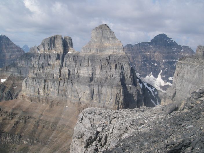
View across Sentinel Pass (hidden) to Pinnacle Mountain (3067 m)
in the center of the frame and Eiffel Peak (3084 m) directly to the left.
5580:
Steep talus typical of the middle portion of the route.
5593:
The 15-20 foot high step forming the crux of the route under dry conditions.
Climb just left of the paint marker and then move to the right below the block
at the top of the frame. There is a fixed anchor above for those who prefer
to be belayed here. Pay particular attention to your location since you will need
to find your way back here on the descent.
5592:
The long but easy route up the summit ridge.
5589:
View from high on the summit ridge to the southwest.
Pinnacle and Eiffel are in lower quadrant of the frame.
5584:
Looking down the final portion of the summit ridge.
Note Pinnacle Mountain and Eiffel Peak far below on the right.
5587: Summit!
5588: View to the northwest.
Paradise Valley is in the foreground with Mount Lefroy (3423 m)
and Mount Victoria (3459 m) among the peaks visible behind.
View across Sentinel Pass (hidden) to Pinnacle Mountain (3067 m)
in the frame's center and Eiffel Peak (3084 m) directly to the left.