Elevation: 9595 feet Prominence: 5030 feet Location: 50:43.0 N 122:30.6 W Backroads Mapbook: Vancouver, Coast & Mountains, Map 42:G6 Climb Duration: 2-3 days. Difficulty: Class 2, mostly off-trail. Grizzly country…
Driving Instructions: From the small hamlet of Gold Bridge, British Columbia
(limited food and services available), head south on the paved road to the old mining town
of Bralorne. Near where the pavement ends make a left uphill onto the Kingdom Lake FSR.
Follow the main road (active logging in 2005) up the valley to a point just beyond
the bridge crossing at Piebiter Creek.
Flat tent sites are available here.
Be aware that the beginning of the trail leading to McGillivray Pass can be
fairly difficult to locate. Look for a somewhat indistinct and overgrown
track
heading left just beyond the bridge. It traverses slowly uphill entering the
forested slopes about a half mile ahead (SE) and a hundred feet or so in elevation
higher on the north side of the valley. You will know you are on the right route
once you enter the forest as the track
becomes much more distinct.
If you camp at the road the evening before I would highly recommend spending an hour
or so scouting out this section.
Description: Whitecap Mountain is the highpoint in the Bendor Range,
a region offering good opportunities for high alpine traverses.
Many relatively easy (non-technical) ascents in a remote setting are possible here.
Although the summit of Whitecap contains a significant
glacier, the route from
McGillivray Pass is nontechnical offering pleasant rambling through mostly open terrain
before ascending to the summit.
Having located the McGillivray Pass trail described above, follow it for several hours
up the Standard Creek drainage toward the pass. Eventually the track will become
very swampy passing through
willow thickets.
As you near the pass in this swampy area you will see the remnants of some old cabins.
The pass itself is in somewhat more open terrain beyond.
Once at the pass, turn left uphill on grassy slopes and climb north to the saddle
on the ridge. From this
hillside
you will see a larger, well maintained cabin to the SE
near the head of the McGillivray Creek drainage. From the saddle on the ridgeline
which lies at the head of the Connell Creek drainage, Whitecap and the
remainder of the route
to the summit will be clearly visible as you look down the Connell Creek valley.
About halfway down the valley in a copse of trees on the right hand (south) side
is a small shelter
owned by a local guiding outfit. This is an excellent location
from which to launch a summit climb and provides a place to get out of the weather
if necessary. If you do stay here,
I would suggest sending a small donation - their contact info is posted on a sign there.
From the shelter, simply follow the easy open terrain down the valley to where it bends
sharply to the right (SE) and then head left (NE) up the steep grassy hillside and
scree slopes toward the summit.
The lower grassy portion of this slope is
deceptively steep and an ice ax for balance may prove useful.
On the return, from the saddle above McGillivray Pass, an alternate route traversing higher
on open slopes is possible. This route bypasses the swampy section in the valley bottom.
This alternate route rejoins the main track not far from where it first enters the bog.
Photos (taken August 2005):
1247: The beginning of the track.
The spot where the trail enters the forest
is not in the photograph, but rather out of the frame to the right.
1248: Camping near the trailhead.
1250: The location where the trail enters the forest. Once here the route becomes easier to follow.
1251: Brushy thickets in the swampy region. Notice the old cabin in the lower center of the photo.
1254: View down the McGillivray Creek valley from the meadowy hillside
above McGillivray Pass with the newer cabin seen below.
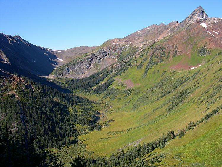
1258: View from the saddle down Connell Creek with Whitecap behind in the clouds.
1261: Shelter
1264: View back toward the saddle. Mt Piebiter is to the far left.
1266: About halfway up Whitecap from the valley bottom.
1267: View toward the summit. The route follows the easy scree to the right.
1269: Near the top
1272: Summit view
1278: Summit snowcap
1283: View back down the route from near the top.
1289: Inside the shelter and out of the rain…
View back to the saddle with Mount Piebiter at far left.