Klickitat County Highpoint Trip Report

Measurement of "The Pinnacle"

Dates: May 18, 2003 and October 18, 2009
Author: Bob Bolton

participants: Dean Molen, Don Nelsen, Ardith Bowman and Bob Bolton

photograph album (essential to the report)

Note on Nomenclature - Adam Helman

The appelation "Indian Rock" is used here to designate a 5,823 foot benchmark at the southern edge of a forested plateau containing three of four Klickitat County highpoint contenders. This usage has become standard practice in the county highpointing community (henceforth, "cohpcomm").

However the USGS 24,000:1 topographic chart designates as "Indian Rock" what the cohpcomm, and this report specifically, both refer to as "The Pinnacle" some 5/8 mile to the north.

This confusing state of affairs resulted because the cohpcomm was unaware that "The Pinnacle" has an official name, specifically, "Indian Rock".

Preamble

The highest point in Klickitat County, Washington was the quest of two outings, one with Dean Molen, on "Mount Saint Helens Day" (May 18) of 2003, and another on October 18, 2009 with Don Nelsen and Ardith Bowman. The problem has been that nobody has really known where the highest point is, until this last visit when we set out to determine this once and for all.

This report describes the problem and its resolution using text and pictures (see the above link to my photograph album). As it turned out, we happily were able to resolve the question without burning down the trees.

May 18, 2003 with Dean Molen

On our approach hike we were blocked by snow quite some distance away, so had to hike a long way up the road. There is no distinct peak, and there are good-sized trees all over the highest area. Those trees are the cause of the difficulty finding the highest point. There are rock outcrops hidden in the trees, and if one is on high ground but can't be seen from a distance due to trees, it would be very easy to miss it.

Two rock outcrops have been identified which seem to be good candidates for the highest point. However they can't be seen from one another, so a hand level is useless in determining the answer to this dilemma.

rock outcrop
Bob Bolton ascends the rock outcrop.
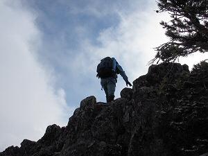
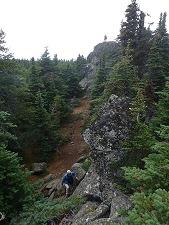
The image lends an idea of its
rise above the general terrain.

Looking north from the 5,823 foot benchmark the area at least gave the illusion of rising ground, which is not desired when searching for the highest ground because there are trees covering the entire area, so we can't see how high the ground is back in there very far, and we also can't see if there are any significant rock outcrops standing up among those trees. Big problem when looking for the highest point!!

More Background

In Andy Martin's County High Points is mention of a rock outcrop to the east-northeast that is visible from the 5,823 foot benchmark area. The initial estimate was that this rock stands about 10 feet higher than the benchmark.

In Fall 2009 Edward Earl and Greg Slayden determined using a hose level technique that the top of the rock is approximately six feet higher than the benchmark, making its elevation approximately 5,829 feet.

Unless a higher such outcrop were to be located, this appeared to be the highest point in Klickitat County.

Dean and I went over to the rock outcrop and climbed to its top. Looking approximately NE from the rock outcrop's top, one notes that the tree tops in this direction are higher than the top of the rock. Thus the outcrop cannot be seen from points north.

By contrast, the view "southish" from the rock outcrop shows lower ground and long views.

A view to the east shows that terrain is lower with gentle slopes.

view NE
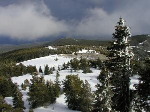
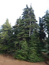
Looking roughly south from
atop the rock outcrop,
even this treetop is higher
than our viewing point.

Dean and I were quite comfortable in our belief that we had done all we could do to locate the highpoint of Klickitat County. On our hike back to the car we decided to veer off a little to the west and see what we could see. We located a rather tall-looking outcrop behind me; and immediately assumed that we had been dropping enough from the benchmark area that this outcrop would not make up the difference. However we decided to go over to it and at least climb it and touch its top in case later information might prove that this is indeed the highpoint.

This rock has since been dubbed the "The Pinnacle" to distinguish it from the ENE outcrop, which was similarly dubbed "The Outcrop".

Dean scrambled up The Pinnacle first. Dean then appeared considerably smaller and farther away than I seemed in the photo he took of me topping out on The Outcrop. I know, this is not in the least scientific due to many factors, but rest assured that The Pinnacle's top did seem quite a bit higher above the ground than did The Outcrop's top.

Note that there is a 5819T on the map just north of that point identified as the top of The Pinnacle. Note that there is a red box with a red plus sign just to the right of the 5819T. Also note that the highest contour on the map is 5,800 feet. The base of The Pinnacle is within that contour, meaning that the ground beneath The Pinnacle must be something over 5,800 feet, and the photo of me with The Pinnacle behind me shows that there was rising ground leading up to The Pinnacle from the SW. Also remember how tall that rock seemed to stand above the surrounding trees, giving the impression that it had to be at least 15 feet tall. Given all these factors, it would appear that the 5819T COULD NOT BE REFERRING TO THE ELEVATION ON TOP OF THE PINNACLE. It therefore is very likely higher than 5,819 feet.

There is not any indication of a marker on the topo map. Our photo of the marker suggests that it is probably quite a bit newer than the vintage of this portion of the map, which argues against the 5819 measurement being applied to the marker.

So what DOES the 5819 measurement apply to? If you go back to Acme Mapper and drag the map around your screen for awhile, you'll see many other measurements annotating the map. Each one is associated to some sort of cross hair annotation. Some look like the letter "X", some look like a plus sign within a circle, and others look like this one with a plus sign inside a square. This strongly suggests that the 5819 measurement therefore must be referring to the cross hairs inside the red box beside the 5819T annotation.

So 5819 is likely the elevation of the ground ENE of The Pinnacle. We have no idea how high the ground is around The Pinnacle except that it is above 5800 feet and below 5840 feet. It could be either higher or lower than 5819 feet. So the top of the rock is very likely higher than 5819 feet, but is it higher than 5829, which is the approximate elevation of the top of The Outcrop?

That's the big question, the dilemma of Klickitat County. Neither of those two highpoint candidates can be seen from the other, so it is not possible to simply use a hand level to decide this question.

At this point, if I were a betting man, I'd say that there's a good chance that the Klickitat HP is the top of The Pinnacle, which would probably have to be only 15-20 feet tall AT THE MOST to reach higher than The Outcrop.

October 18, 2009 with Don Nelsen and Ardith Bowman

Don Nelsen, Ardith Bowman, and I set out to determine once and for all where the highpoint of Klickitat County is. We gathered some crude tools that we felt would get us to within a few feet of the truth. Our purpose was not to measure the highpoint, but to prove what IS the highpoint; and we didn't believe that high precision would be needed for the proof.

calibration
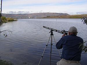
Sight calibration while preparing
to revisit Klickitat County.

We calibrated the scope. In one photograph, Don is far away holding a tape measure at the same distance above the water as the scope while I fine-tune the scope with its adjustment screw. OK, fine-tune might be a bit of an exaggeration given that we're using a light-weight tripod, however we did get it within 5 or 6 inches max at 383 feet. Close enough for our purposes!

We brought three 10-foot lengths of telescopable plastic pipe to use for our surveying efforts. When we arrived at the Indian Rock plateau and parked within a short walk of the 5819 benchmark, Don got out the black spray paint and painted marks one foot apart. There was fog that we feared would hamper our efforts. Happily it evaporated soon after our arrival, and we had no trouble with the elements after that.

poles
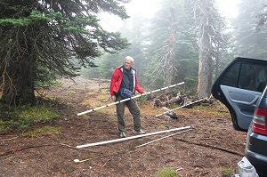
Don Nelsen with some of
the ten foot plastic pipe.

I had placed a waypoint for the "+" sign near the 5819 annotation on the topo map into my GPS, so I used the "Goto" feature to locate the benchmark. It took us to within 16 feet of the BM, which then was easily located.

At the 5819 foot BM my GPS unit, having been on for a long time, settled down to the elevation quite quickly, and I was able to photograph it while displaying an elevation of 5819.

The Pinnacle
Ardith Bowman atop
"The Pinnacle". Note its
height above the terrain
with her as yardstick.

We also used the GPS Goto feature to locate The Pinnacle, using the coordinates captured on my visit there in 2003.

Atop The Pinnacle my GPS unit shows 5858 feet, which my previous model also showed when it was photographed at the same spot in 2003. Don's more advance unit shows 5856 feet.

On our second attempt we were able to locate a tree that was visible from the top of The Pinnacle. We hoisted our makeshift measuring rod up into the tree, and it was easily seen at the distance we were working from, around 450 feet. Again, our purpose was not precision, so we could live with the small angle at which our measuring rod leaned.

erected pole
The erected pole sighted
with our scope for assaying
"The Pinnacle's" height above
the 5,819 foot benchmark.

Once we found our tree, we were able to set up the level and scope. Don placed the apparatus at a location where the scope can be very close to the height of the top, while it also had an angle past the closer trees to our measuring rod. Using this setup we were able to get an approximation of the elevation of The Pinnacle. Using the 28 feet of pipe plus an 11-foot wood stick, Don hoisted the measuring rod yet another foot off the ground until it would go no further, being caught by the tree. At that point it appeared that the top of the pipe was within about one foot of the horizontal cross-hair in the scope.

Using 5819 as the base, which is very close, add the 28 + 11 + 1 for a total of 40 feet that the top of the pipe was above the ground when it came to about a foot below the cross-hairs. This sums to an elevation of 5860 feet on the top. This elevation is probably within plus or minus 5 feet. This value is fully 37 feet above the 5823 BM, and 31 feet above the 5829 rock outcrop that we've believed was the highpoint until now.

After we determined the approximate elevation of the top of The Pinnacle, we wanted to make sure that there were no higher rock outcrops hidden in the trees. We reasoned that it all depended on how high the highest trees were on the plateau. If we were higher than them, since there were no rock pillars as high as those highest trees, there couldn't be any higher spot. So we set up the level and scope to sight along the line of highest trees, which happen to be between us and the 5823 BM and the 5829 Outcrop. We found that there was sky visible at the height of the horizontal cross-hair all along the highest terrain, although the highest trees extended above the cross-hair. All other trees were therefore below us, as would be any rock pillars hidden by those trees. There were no rock pillars along the highest skyline.

Conclusion: The Pinnacle is the highest point of Klickitat County.

Don and I celebrated our discovery of the Klickitat County Highpoint.

After collecting all our gear and returning it to the car, we headed over to the previously believed highpoint, the rock outcrop ENE of the Indian Rock BM that was recently measured using a hose level procedure to be 5829 feet.

Atop The Outcrop Don's GPS unit displayed the expected 5829 feet; while at the Indian Rock benchmark our units measured 5823 feet. These values serve as secondary verification that The Pinnacle is higher than either locations.

celebration
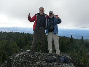
Don and Bob celebrate
their "discovery" of the
true Klickitat County highpoint.