Thurston County Highpoint Trip Report
Quiemuth Peak
Date: October 10, 2009
Author: Greg Schmidt
note: All elevations in this report are from my altimeter
watch calibrated at the summit.
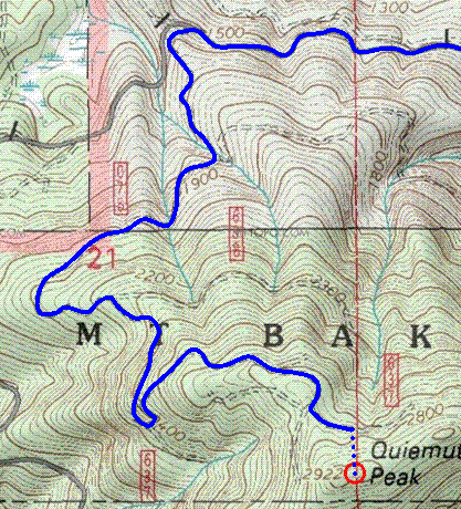
After studying the topo map, I put together a route up the peak's northwest slope
following abandoned roads almost all the way to the summit.
These made for an easy hiking path with only two hundred feet of scrambling at the end.
Drove Pleasant Valley Road to Forest Service Road 74. Parked near the two locked gates
and followed the left road (74) headed northwest. Hiked along the paved road
past a couple big washouts. Turned left off the paved road onto an abandoned
unpaved forest road.
This intersection
is at WGS84 datum (46.77571° N, 122.30445° W) and 1,482 feet elevation.
Turned right at an intersection at 1,702 feet.
Stayed left at a Y intersection (not on the map) at 1,972 feet.
Turned right at an intersection at 2,204 feet.
Turned left at a hairpin turn/intersection at 2,353 feet
Stayed right at an intersection at 2,603 feet.
Turned left at an intersection at 2,686 feet.
Left the road/trail at about its highest point at 2,705 feet,
and scrambled south up the fall line through the forest to the summit at 2,922 feet.
4.7 miles from car to summit. There is a little pile of rocks and a register.
No view since it is all forested.
Picking up the route again on descent was easy since the last bit of abandoned road
continues farther east, so just head due north from the summit and turn left
at the first road/trail.
|
|
Quiemuth Peak route map.
|