|
Kilauea |
|

|
am exceedingly goal-oriented - and mountains fit the bill. So even though I had not climbed Mauna Loa from the south, I still wanted to experience this route, albeit in the abbreviated form of a hike to Red Cabin at 10,035 feet elevation followed by descent the same afternoon. Unfortunately the Park Service has regulations that prohibit use of the Mauna Loa Summit Trail except as a multi-day backpack.
In lieu of this politically-based impasse, I decided to fill my day by going on a few shorter hikes, largely on level terrain, within the Park boundaries. I felt as if my day was being wasted in that I was not gaining elevation - sensing no emotional or physical challenge in simply hiking along maintained and largely level trails within the National Park.
Why must I be so hard on myself?
|
|
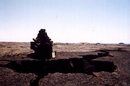
Deep earth cracks at a remote junction along the Desert Iki Trail. |
My first hike was a four mile round trip as a portion of the Desert Iki Trail. Here is a desolated landscape of igneous rock formed from both the pahoehoe and 'a'a types of lava flows. The vegetation included many succulents and other varieties reminiscent of the Mojave Desert in southern California. The annual rainfall is far less than along the luxuriant Hilo coast but a few dozen miles to the northeast.
The Desert Iki Trail continues for several miles and is dotted by backcountry campsites for which permits are required in advance. I only wanted the "look and feel" of the region - something that proved achievable in a few hours without having to sleep overnight.
Along my hike I took a brief detour to climb a small hill formed from tilted sheets of black igneous rock. I just had to do it - getting to the locally highest point is in my blood.
The trail is simply a path made discernible by previous footprints and modestly-sized cairns every several dozen feet. I walked slightly off-trail because it was sandy and so made for slower progress than the ropy pahoehoe-based rock to either side. As with my ascent of Mauna Loa, I was at times atop lava tubes that a heavier person could have broken through.
I spent a good thirty minutes at the turnaround point, as a trail junction, seemingly in the middle of nowhere. Nearby were large earth cracks that merited inspection.
|
|
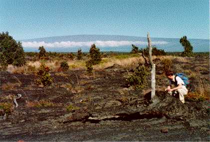
The author inspects a dead tree along the Devastation Trail. Mauna Loa is visible in the distance. |
The short Devastation Trail, on the southeast rim of Kilauea Caldera, takes one through a forest destroyed by encroaching lava - burnt and fallen trees amidst a sea of ash and rock. I noted that the forest was being rejuvenated since it appeared less "devastated" than in my visit several years earlier. The area is a study in revegetation much in analogy to how the destroyed area from the Mount Saint Helens eruption is currently recovering.
Kilauea Iki crater was the sight of spectacular lava fountains in 1960 that reached 1,900 feet high - a standing record. Also on the southeast rim of the far larger Kilauea Caldera, Kilauea Iki crater has a trail with its namesake. The four mile round trip involves a 400 foot descent from the Kilauea Caldera rim followed by a traverse of the Iki crater floor. I repeated this hike, as with the Devastation Trail, because of the extraordinary scenery.
Returning to Nakamani Paio Campground, I had polenta with extra aged parmesan cheese for supper. It had been an enjoyable, albeit not a particularly challenging day.
| previous page - North Point | next page - Rest and Return |