Bingham County Highpoint Trip Report

Date: August 1, 2010
Author: Adam Helman

note: All coordinates are in the WGS84 datum.

This effort was part of a larger journey collecting Idaho and Montana county highpoints in August 2010.

The previous evening I camped alongside a historic marker at the "Y"-junction noted in Ken Jones' report along broad, graveled Blackfoot River Road. Coordinates are (43.20968° N, 111.99729° W). The mileage he notes, 24.8, is a few tenths high - and in accordance with his statement, "I think this rental read a bit high".

Amidst some trees and protected by metal railing is the foundation of a former post office or schoolhouse - I simply forget which after five weeks. The railing has break points that allow for human entry yet not horses owing to their convoluted shape. It's a good place to "hang out" rather than at the trailhead (see below) where one's presence might raise suspicions about the intended goal.

The next morning I arise timed such that I reach this junction exactly at first light, well before prying eyes have a chance to question my presence. It is 7 road miles from the cited "Y" to this point, one that is a mere few hundred yards beyond structures at a road-bend on the right side and yet hidden from their viewshed. I doubt they are occupied.

THIS IS THE TRAILHEAD because 1) there is a locked gate with "NO TRESPASSING" posted just one or two hundred yards along the southeast-trending dirt track; and 2) the jeep track is now completely overgrown with brush. Only an ATV has a chance of negotiating it as of calendar 2010.

The USGS 24,000:1 chart shows a junction at (43.16052° N, 111.91438° W) after one-half hour of brisk hiking. The right fork is barely visible. Take the left fork by staying straight - this path is most obvious and trends in the desired direction.

Some hour or 75 minutes from the car I top-out on a ridge at (43.16559° N, 111.90348° W); and enjoy a 15 minute breakfast break. Normally I'd have milk and cereal just before setting out. However that's counterproductive in the present case as I wish to minimize trailhead time due to access concerns. Hence I take these items with me.

Descend perhaps 100 feet along the northeast-trending track. I encounter a whole bunch of cows, and briefly enter the forest to pass around this mass of moronic flesh. After about two-thirds mile from the ridge-top one reaches another junction at (43.17614° N, 111.89240° W) with tracks leading east and north.

I go east (and then southeast), a plan which I do NOT recommend. It takes one too far south when the goal is generally to the northeast. Instead, take the north-trending track until it fades away at roughly (43.18083° N, 111.89125° W). From here hike cross-country about 0.4 mile northeast until reaching the obvious north-northwest / south-southeast ridge.

Atop this ridge is a dirt track, and you see the goal to your northeast for the first time. One could drop-down into the interventing valley here. However on bottoming-out one must cross very wet marshes prior to ascending west slopes of Blue Ridge. A better plan is to hike the ridgeline track north until roughly west of the highpoint ... and then descend only 50 feet, at the northernmost extent of the narrow valley, prior to ascending steep slopes east-southeast to the highpoint.

On my ascent I exit the ridge too early, and suffer through both wet marsh and much foliage on the subsequent first few hundred vertical feet of west-facing slopes. Not desirous of repeating that mess I descend the suggested route. The place for ideally leaving the ridgeline track will be obvious on inspection. Once in the valley you must bushwhack through perhaps 100 yards of aspens going northeast - but soon the "way is clear" as one ascends shallow slopes to the southeast of point 6649 (which should not be climbed) and with only intermittent brush ... followed by a steep final summit push.

I estimate 9 miles round-trip for the suggested route. My effort entailed 2,800 feet of total elevation gain. In contrast, the suggested route should be roughly 2,500 feet after accounting for the ups-and-downs on the north-trending ridgeline track and reascent to my breakfast point.

Bingham County is a "non-classic", an effort that one would only do for completing the Idaho county highpoint list. I am glad it is over with: my very last western USA county highpoint with a private land ownership issue.

summit cairn
The summit cairn with a view generally west. Red-brown object at its lower left contains lunch.

The north-trending ridge with dirt track is visible
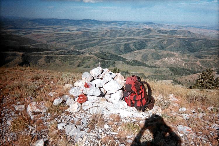
as the closest ridge in the distance as it
roughly parallels the photograph's bottom edge.