Wallowa County Highpoint Trip Report

Sacajawea Peak (9,838 ft)

Dates: August 5-6, 2004
Author: Adam Helman

Note 1: All UTM coordinates are zone 11 and use the NAD27 datum.
Note 2: Click on either photograph for enlargement.

Preamble

Note: Please skip this section is you are only interested in climbing Sacajawea.

This climb was part of a larger road journey where I visited several county highpoints including Gannett Peak, the Wyoming state highpoint. A general review of this trip is available.

Overview

Sacajawea is the highest point of the Wallowa Mountains, a compact range in extreme northeast Oregon. A sister summit, Matterhorn, was for decades believed to be taller. Today accurate measurements indicate that Matterhorn is slightly shorter (9,826 feet), much to the chagrin of former climbers who believed that in climbing Matterhorn they had reached the highest point in eastern Oregon.

Sacajawea also has 6,388+ ft of prominence, substantial enough to place Sacajawea eighteenth on the list of fifty greatest prominences in the forty-eight contiguous United States - the so-called America's Fifty Finest. It is also second only to Mount Hood in prominence among all Oregon summits.

Sacajawea is normally climbed over two days from the Wallowa Lake trailhead, with an overnight camp at beautiful Ice Lake. The twenty mile round-trip affair involves a net elevation gain of 5,200 feet. A long, twelve-hour dayhike is also possible, as was recently demonstrated by Edward Earl. He did, however, express his yearning to have stayed at Ice Lake for its aesthetic value.

Sacajawea can also be climbed more directly via the Hurricane Ridge route. This fourteen mile round-trip involves a net elevation gain of 4,800 feet and a high stream crossing of Thorp Creek in early summer.

Although most climbers of Sacajawea do not get there via Hurricane Ridge, because the route exists and has a total gain less than 5,000 vertical feet, the current elevation gain rules preclude Sacajawea from being placed on the 5,000+ foot elevation gain list. I think that is ridiculous - there was unamimous agreement at the Wallowa Mountains Visitor Center that the Ice Lake approach is far the more popular means of climbing Sacajawea. After a total gain of 5,700 vertical feet on day one of my climb, I certainly feel this state-of-affairs is unfair to both myself and the vast majority of Sacajawea summiteers - past, present and future.

I climbed Sacajawea in calendar 2004 in part because it is the bicentennial of the famous expedition by Lewis and Clark to explore the Lousiana Purchase and points beyond. Sacajawea was the Indian guide whose services were essential to that expedition's success. Her likeness recently graced a legal tender coin worth one dollar.

Approach - Ice Lake

From Enterprise, Oregon drive south on highway 82 through the tourist trap called Joseph. Continue south on route 82 along the east shore of Wallowa Lake to a trailhead carpark at UTM (483371 E, 5012411 N). Fill out the wilderness permit form and retain the yellow copy. As of 2004 there is no fee.

The trail begins as a broad path covered in wood shavings, quickly heads WSW, and then, after one-half mile, heads south, paralleling the West Fork of the Wallowa River along its eastern edge.

After 2.8 miles and 900 feet of gain, encounter a well-signed junction at UTM (481954 E, 5009083 N). Take the Ice Lake Trail to the right. Soon you cross a well-constructed footbridge over the Wallowa River and perform a series of switchbacks to nearly 6,000 feet.

The trail straightens, trending SW until another series of switchbacks from 6,200 to 6,600 feet. Adam Creek is crossed at about 6,800 feet, after which another set of switchbacks take one from 7,000 feet to 7,700 feet - nearly the elevation of Ice Lake itself. Note the waterfalls and rapids of my namesake.

Ice Lake
Ice Lake from the east shore.
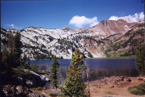
Note the big boulder at near left;
Matterhorn at extreme upper right (gray slope);
and the puffy, white clouds.
The pack trail ends at the northeast shore of Ice Lake just where it drains, every so slowly, into Adam Creek as its outlet stream - UTM (478865 E, 5008478 N). Ice Lake is shown on the USGS quadrangle at 7,849 feet elevation.

Camping is available via an easy log crossing of Adam Creek within a few dozen yards of the outlet. I elected to pitch my tent just fifty yards southeast, near a family of four who were enjoying their summer vacation in the backcountry. More camping space is available by contouring around the east shore to a broad projection of land that juts out nearly into the lake's center.

I arrived at camp after 3 hours 50 minutes elapsed time, including 3 hours of actual travel and 50 minutes consisting of three breaks spaced roughly 800 vertical feet apart. You should do better if carrying just a daypack. Given my overnight pack I did OK.

Climb

From Ice Lake there are two main routes to Sacajawea, each with minor variations depending on the climber's whim and willingness to tolerate varying amounts of scree, steepness, and overall exposure.

One route is to climb directly NW from the northern shore (or NE edge) of Ice Lake up the Hurwal Divide; walk the high ridge west to the unnamed 9,775 ft peak one-half mile south of Sacajawea; and then traverse the intervening ridge to the summit (class 3).

Two summers previously I climbed Red Mountain of Baker County, and spied the steep scree up the Hurwal Divide from afar. It was a sufficiently sobering an observation that I elected to climb Eagle Cap of Union County instead of Sacajawea, so providing my desired Canada to Mexico link. At the time, summer 2002, it appeared to be a forty-five degree slope. Upon closer inspection from Ice Lake the grade is not at all that precipitous.

The second route is to start on the climber's path towards Matterhorn, and then divert at the opportune location for Sacajawea instead. I chose this option, beginning with a usetrail that goes around the north shore of Ice Lake.

At the NW edge of Ice Lake the latter trail begins trending uphill as a faint climber's path - UTM (478415 E, 5008462 N). The path leads west in the general direction of the ridge joining Matterhorn and the unnamed 9,775 ft peak (henceforth P9975). After perhaps 500 vertical feet the path becomes difficult to follow, and cairns mark the way to avoid losing it completely.

At about 9,050 feet the cairned path starts heading more towards Matterhorn and away from Sacajawea. Setting a GPS waypoint here for my return, I headed cross-country for the summit of P9775. This entailed climbing down on shallow slabs fifty feet, followed by a moderately steep route directly up the southeast slope of P9775 to its summit. The route is a combination of large slabs and scree.

Once atop P9775 I spied the final objective to my north and slightly east. Walking the ridgeline is definitely class 2 for nearly its entire length, about one-half mile. Furthermore, there is no easy way to avoid a few sections that must be called class 3, the result of several rock outcroppings which require either passing over (class 3) or climbing down and around them, on the west slope, with consequent need to regain the lost elevation each time. I elected to remain high, as suggested by a faint path, and suffer the class 3 sections rather than seesaw up-and-down to avoid the outcrops.

A minor subpeak of Sacajawea is the first bump encountered at the north end of this ridgewalk. It is easily walked around on the north side without the need to scale it. The true summit is a few minutes walk ENE thereof, UTM (477091 E, 5010002 N).

from Sacajawea summit
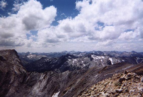
View southwest from Sacajawea Peak's summit
towards numerous mountains in the Wallowa Range.
Matterhorn is at far left, accessed via the
foreground ridge.
The saddle in-between P9775 and Sacajawea is shown as 9,560- ft with a 40 foot contour interval. Thus some 400-500 feet of elevation gain is required beyond the net gain implied by simple difference of summit elevation and trailhead elevation.

Adding this 400 feet to the 2 x 50 = 100 feet of elevation gain where I had left the path to Matterhorn, and I ended up with a 5,700 foot day - not including the minor ups-and-downs along the main trail as it parallels the Wallowa River.

I had left camp around 11 a.m. and was on top after 2 hours 15 minutes elapsed. Although I wanted to eat badly, I sacrificed the opportunity due to threatening clouds.

Although it had taken me 45 minutes to do the ridge traverse from P9775, I required only 30 minutes on the return. I was understandly tired, and this together with the cloud situation, prompted me to forego entertaining Matterhorn's summit.

I finally took a long lunch break at the 9,050 foot level where I had left the faint climber's path which leads to Matterhorn. It was here, recall, on the ascent that I had commenced a cross-country route leading to Sacajawea via P9775 on the intervening ridge.

The "everything bagel" (studded with twelve kinds of nuts and seeds) never tasted better, much of it with canned, deviled ham and romano cheese. I made milk from water and the dry powder, all to wash down a large coconut granola bar.

Back in camp by 3:36 p.m, I lay in my tent and read from some books on state and county highpointing. Dinner came around six, and I shared in conversation with the family camped nearby. I accepted their extra rice with "teriyaki" chicken and green beans, and for dessert made myself chocolate pudding with a final granola bar.

I learned that the father had watched me advance up the face of P9775 with binoculars, so providing his mid-day entertainment to some degree.

I spent a good amount of time exploring a big boulder at lakeside, as well as the outlet to where Ice Lake drains into Adam Creek - a most pleasing brook indeed that, lower down, supports a series of spectacular waterfalls.

The following morning I set out amidst foggy skies at just past six, and arrived at the trailhead some three hours later. The family camped nearby was prepared to hike out as well, albeit not until they had their gourmet breakfast of pancakes with pre-cooked bacon and eggs. I had no time for such luxury - my truck had an elk encounter of the damaging kind while driving to the trailhead, and I needed the entire business day to effect temporary repairs for the long drive home.