Wyoming and Oregon end July early August 2004 Trip Report
© August 2004 Adam Helman
(Click on any image for enlargement.)

Background

Gannett Peak, highpoint of Wyoming, was the chief goal of this road journey. Subjectively rated the toughest of the lower '48 state highpoints, climbing Gannett Peak is an arduous task by any measure.

I had planned, along with Chuck Bickes of Massachusetts, to climb Gannett Peak the previous year. Chuck, a state highpointer, had but two summits remaining to earn fifty state completion status - an accomplishment of grand proportion seeing as Mount McKinley, highpoint of Alaska and North America's highest summit, is required.

Chuck had already scaled McKinley, and, with only Idaho's Borah Peak and Gannett Peak remaining, was eager to finish the list.

In 2003 the opportunity arose for Chuck to join a Mount Everest expedition. With no intention of reaching the summit, Chuck wished to fulfill his dream of traversing the treacherous Khumbu Icefall on Everest's lower slopes. This he did, reaching advanced base camp at some 20,000 feet. Unfortunately this adventure bankrupted Chuck's vacation allowance, forcing a postponement of Gannett Peak to the following year.

Springtime dialogue focused on deciding the approach route for Gannett Peak. Eventually Chuck and I agreed to a loop route wherein entry would be via the shorter Ink Wells Trail, followed by exit via the considerably longer Glacier Trail.

The Ink Wells Trail required crossing Indian lands, and an Indian outfitter would charge us for the drive to the trailhead. In compensation we would have the highest starting elevation and the least horizontal distance of all possible approaches. Since previous Gannett Peak trip reports complain about brutally heavy packs, it seemed prudent to spend $100-$200 per person to arrive at high camp relatively fresh.

Chuck and I tried hard to recruit additional people because there is safety in numbers on a remote, ice-clad mountain. Surprisingly, I had no success in recruiting county highpointers to the task, and this despite the fact that there were several people who had Gannett Peak on their wishlist. Part of the problem, I surmise, is that climbing Gannett Peak requires a full week of vacation time from work, a week that could be filled with several lesser hikes and/or less strenuous activities than the consecutive twelve hour days on one's feet which Gannett Peak offers.

In contrast, Chuck recruited his friend Stony Burk, also from the East Coast. With three people we were confident that most problems could be addressed should they arise on summit day.

It is noteworthy that Chuck originally desired a traverse of the Wind River Range, via entry at the Ink Wells Trailhead; a climb of Gannett Peak; a carry of full packs over Dinwoody Pass; and exit at the Pinedale Trailhead on the south. This crossing of the Continental Divide would be a dramatic finish to Chuck's state highpoint quest.

Unfortunately the placement of two automobiles, one at each trailhead, was required - and the driving distance between the two is some 180 miles. The additional time and effort suggested cancellation of this bold plan.

Sacajawea Peak, highpoint of Wallowa County in extreme northeast Oregon, was the secondary goal of my road journey. I had been denied an attempt on this summit twice previously, including the very last county highpointing trip due to snow conditions. In each case I had aborted the climb before setting out on foot, viewing the chances of success as small before wasting time and energy on-foot.

Although the additional driving from Wyoming was considerable, I was dead set on Sacajawea as part of an impending Oregon state completion. Furthermore, Sacajawea is the highest summit in eastern Oregon; highest in the Wallowa Range "Little Switzerland"; and has substantial prominence (6,388+ feet) - the greatest in Oregon after Mount Hood.

Several additional county highpoints were targeted on my journey. Two of them are the highpoints of Utah counties, inching me quite close to an impending Utah state completion on a subsequent trip around Labor Day. Three Wyoming county highpoints besides Gannett Peak were planned, as well as at least one Idaho county highpoint: it would be a shame to drive through southern Idaho, from Gannett Peak to Sacajawea, without getting some highpoint for the effort and expense.

With Gannett Peak as the highpoint of both Fremont and Sublette Counties, I envisioned gathering nine counties on my trip - a number which would place my grand total county count at a nice, even 250.

Trip Details

Friday, July 23

I had trained myself to awaken one hour earlier each morning for some three days. Thereby I was almost refreshed when I arose at the unlikely hour of 3:40 a.m. On the road at 4:15 a.m., I was prepared for a lengthy driving session, one which saw me in Ogden, northern Utah, by 6 p.m. Mountain Time.

It was a record 775.0 miles for me, at least according to my Tacoma's trip odometer. The aim of driving so far was to capture both the Cache and Rich County highpoints on the same day, two Utah highpoints traditionally done together.

Saturday, July 24

I had human company on the summit Naomi Peak, the Cache County highpoint. Hiking times include 1 hour 10 minutes on ascent, and 55 minutes on descent. Owing to a protracted summit siesta, the elapsed time for the entire climb was some three hours - still quite good for eight miles with 1,700 feet of elevation gain.

from Naomi Peak summit
View northwest from the summit of Naomi Peak.
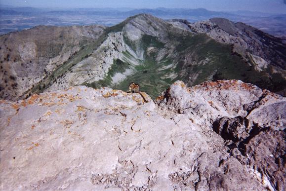
Note the rodent with my salted peanut
(click for enlargement).
After a short drive I started up Bridger Peak of Rich County. At the top I signed into the summit register, names all of county highpointers. It was my twenty-seventh Utah county highpoint and 243rd county overall - both powers of 3.

I drove down to Bear Lake and then passed into Wyoming, eventually sleeping in Rawlins, Wyoming fully halfway across the state.

Sunday, July 25

Time for Medicine Bow Peak of Albany County, Wyoming. The liner along its western slope serves as the Carbon County, Wyoming highpoint.

The shorter route via Lewis Lake described by Mike Schwartz in his trip report was unavailable due to construction work. A sign along the main highway said that even pedestrian traffic was prohibited.

Thereby I drove back a mile or so to the West Lake Marie trailhead and commenced the seven mile route, passing by the Carbon County liner enroute to the summit. I located the cairn constructed by a previous highpointer, placed within five meters of where my GPS unit suggested for the county boundary.

After summit conversation and lunch I descended and drove east, stopping in Centennial for some soda pop and ice cream. The time for ascent was a rapid 1 hour 35 minutes, with descent taking 1 hour 6 minutes.

I had not planned upon Platte County. However upon passing through Laramie I decided to chance an alternative approach from the west to reach the paved highway 211 leading north from Cheyenne to the Platte County highpoint surrounds. The road deteriorated, and I drove back to Laramie and then to Cheyenne via Interstate 80.

An hour or so later I was opening a wire gate and negotiating a dirt road that hopefully led to one Miller Ranch, from where I would request permission to drive to the highpoint area. The dirt road became a two-track barely discernible in the grass and sage. I turned back. I slept that evening in Laramie, having again passed through Cheyenne.

Monday, July 26

One day ahead of schedule, I made today a driving-only affair. I headed back west on Interstate 80, and eventually went north to the trailhead for climbing Wyoming Peak, the Lincoln County, Wyoming highpoint. After supper, canned ravioli with extra garlic and garlic sausage, I read a National Geographic article and then slept on the Tacoma's driver seat.

Tuesday, July 27

I arose at 5:30 a.m. and was walking by 6:02 a.m. About two miles along the hiking trail, paralleling the south shore of Middle Piney Lake, I missed a (nonobvious) south-to-north stream crossing. Noting the deteriorating path, I wondered if I was off-route. So I headed perpendicularly, that is north, crossing the stream at a narrow point atop a well-placed log or two. Much steep bushwhacking just east of the Wohelo Falls brought me to the correct trail as it trended west to a junction with the Wyoming Main Range Trail in a field at 10,000 feet.

Wyoming Peak
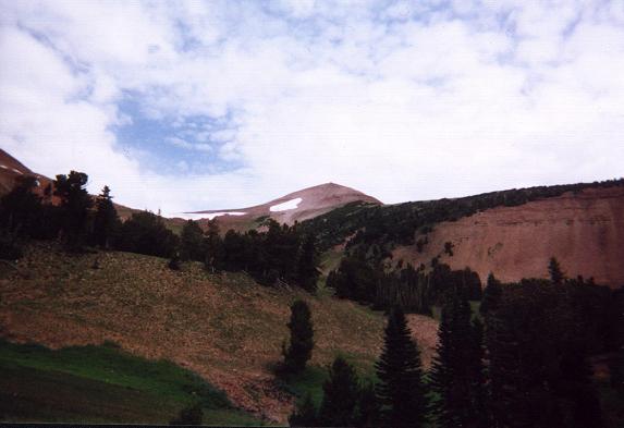
Wyoming Peak from the base of the alpine
bowl to its south, near the
Wyoming Main Range Trail junction.
Saving a GPS waypoint for the return, I climbed northeast up the alpine bowl just south of the Wyoming Peak summit. After reaching the southeast ridge at 10,800 feet, I proceeded up the latter to the very top. I hunkered under the south-facing frame of the delapidated summit structure, eating lunch with a wonderful view of mountains in every direction.

The elapsed time on ascent was 3 hours 7 minutes, and 1 hour 52 minutes for the descent.

In Big Piney I enjoyed a pint of butter pecan ice cream while the air conditioning ran in my Tacoma truck, with several mix-ins such as butterscotch candy.

That afternoon I took a pricey room in Jackson, arriving at just 4 o'clock. An Albertson's was located diagonally across the street, and I used the time to stock-up on additional food for climbing Gannett Peak - as well as buying their entire supply of five ounce Kraft Roka Blue Cream Cheese Spread jars, six total. I had not seen this favorite sandwich treat for years, and, since it requires no refrigeration until opened, took maximal advantage of my windfall. Pints of ice cream tempted me, and yet I held off with the intention of rewarding myself only after climbing Gannett Peak. I also saw a key lime meringue pie for sale. Yum!!

Wednesday, July 28

This spare day was to be used for bad weather. Never applied to that end, I ended up acting tourist, driving past Grand Teton, and into Yellowstone National Park. I bought a stuffed bear (or bison?) at the gift shop, and watched Old Faithful do its thing. Later I hiked the half-mile trail around the famous mudpots and algae-colored hot pools.

Old Faithful
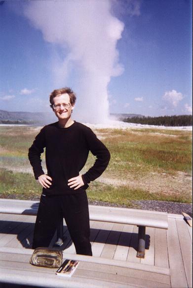
Old Faithful and Adam
in Yellowstone National Park.
I drove back south to Moran Junction and then east to Dubois where motel reservations had been arranged by Chuck Bickes. I was absolutely delighted to learn from the manager that Chuck had paid for my own room!!

By late afternoon Chuck appeared in his truck. He had successfully recruited three additional climbers to go with us, and I was introduced to all of them - Gordon Comstock from Michigan; and a brother-sister pair from the Netherlands.

The brother, Sjaak van Schie, was poised to be the first foreign 48-state completer. The sister, Lidy, a nurse, is an extremely gracious and congenial person. I think that everybody immediately took a liking to her. Importantly, all the new team members had experience and a high level of fitness.

Ink Wells trailhead
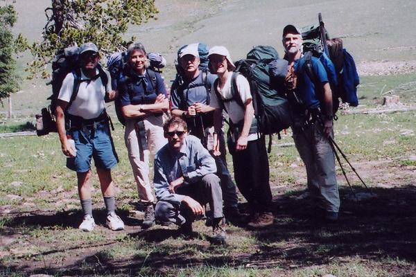
The Ink Wells trailhead. From left of photo,
Gordon, Lidy, Stony, Adam, Chuck. Sjaak is kneeling.
Recalling how much I enjoyed huckleberry treats from after our climb of Granite Peak, Montana in 2002, Chuck presented me with a jar of huckleberry ice cream syrup! I immediately used it atop oatmeal raisin cookies to satisfy my yearning for carbohydrates since I had eaten little for lunch.

I opted to join all at the nearest restaurant, one that served (standard) American fare. Although others enjoyed chicken-fried steak dinners (Lidy had a medium pizza), I ordered a meal-sized caesar salad into which I sliced garlic salami. My onion rings with BBQ sauce were delectable, as was the half-slice of cherry pie for dessert (there were four of us who wanted pie but only three slices left in the kitchen). Topped with sour cream from Sjaak's baked potato it was small but yummy indeed.

climbing the snow chute
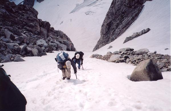
Adam (in back) and Stony climb the steep snow chute.
Stony and I caravaned to the Glacier Trail parking lot, about a dozen miles, and I left my truck there for the exit day of our climb. As seen below this truck placement was never needed.

Thursday, July 29 - Day 1 Gannett Peak Climb

Our successful ascent of Gannett Peak is described most fully in this trip report. Here I provide an outline.

We received a ride to the Ink Wells trailhead by our Indian outfitter, commencing our little walk (!) at the late hour of 11 a.m. We hiked over Scenic Pass at 11,400 feet, and descended to a camp near the Glacier Trail / Ink Wells Trail junction, alongside Dinwoody Creek, seven p.m.

Friday, July 30 - Day 2 Gannett Peak Climb

This short day saw us move camp six miles to the base of Gannett Peak. The stream crossings were a major headache, consuming much time and energy. We arrived at our 10,800 foot site, as the edge of the boulder field and morainal lakes, by three o'clock.

Chuck and Sjaak on top
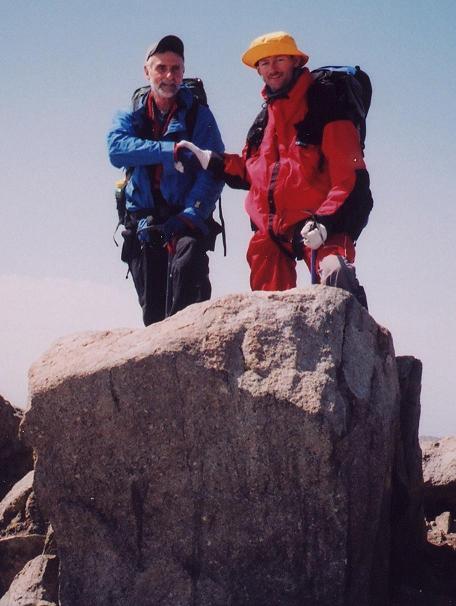
Chuck Bickes, at photo left, and
Sjaak van Schie celebrate their
respective list completions.
I had taken a spill at one crossing, my socks and boots then being dried out for the next day as I wore Chuck's leather boots around camp. Chuck had tennis shoes, and I had spare woolen socks. My goretex-based trousers dried out quickly just wearing them.

Saturday, July 31 - Day 3 Gannett Peak Climb

Up at 3 and off at 4:16 a.m., picking our way for 2 1/4 hours by headlamp and moonlight through the boulderfield. Then, Chuck's crampon strap broke. Sjaak provided a temporary repair and we continued.

Somehow we neglected the turn which would lead us to the standard climbing route. Instead, we climbed the Dinwoody glacier (crevasse hazard small), unroped, to the base of a steep snow chute (12,600 feet). This we climbed some 600 vertical feet, all of us, but especially myself, requiring a good break at top. This chute was clearly the crux of our (impromptu) route.

We were now above the standard crux - bergschrund of the Gooseneck Glacier. After 100 vertical feet of rock scrambling, we again placed on crampons for the final push - one that including a series of false summits along the summit ridge.

Summiting at 11:24 a.m. Mountain Time, Chuck was the first to touch the highest point, followed by Sjaak and a series of photographs. I enjoyed a cocoa and almond pemmican bar, all-the-while wary of descending that snow chute. We left after some forty minutes.

the whole team on top
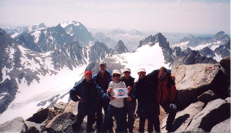
All six expedition members on top of Wyoming.
From left of photo, Lidy, Chuck, Adam,
Stony, Gordon, and Sjaak.
The afternoon sun made quick mush of the snow. It was impossible to downclimb the snow chute without losing one's balance. And so, in turn, every person (including Chuck in the lead) uncontrollably fell down and began sliding, with ice-axes used to control our unplanned glissades.

Gordon's path led treacherously close to the lip of a moat formed by the rock face melting adjacent snow. The look on his face was of terror, arms flailing completely out of control. He stopped just short of disaster.

Back in camp we savored our success, after this, a 13 1/2 hour day.

Sunday, August 1 - Day 4 Gannett Peak Climb

Sjaak and Lidy had an airplane flight from Seattle that suggested only a four day allowance for climbing Gannett Peak, with Gordon as driver from Wyoming to Washington. They "had to" return to the trailhead in one long day. Although Chuck, Stony and I had planned on a six day climb, it seemed prudent to walk out with them.

Gordon slides
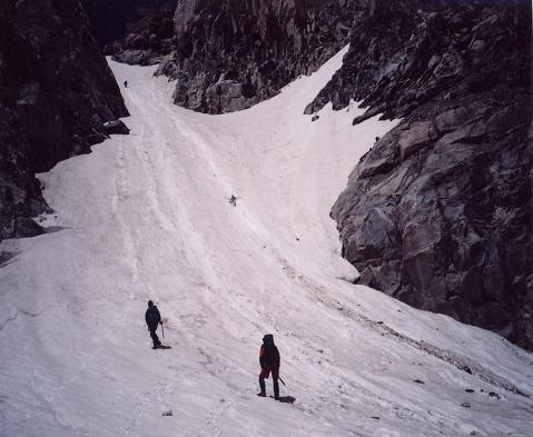
Gordon slides uncontrollably down the snow chute.
A moat lies just beyond the photo's right edge.
We began the dreaded "death march" with a 4 a.m. awakening, and were on-trail at 5:48. The stream crossings were more efficiently negotiated, and we arrived at our day 1 camp area by 9:40 a.m. The uphill slog to Scenic Pass was exhausting, seeing as we had just summited yesterday.

We returned to the Ink Wells Trailhead around 5:35 p.m., with twenty-five minutes to spare before the 6 o'clock pickup time arranged previously.

In Dubois we all attended another restaurant, and I was delighted with the variety of food. My main course was smoked buffalo sausage with grilled onions. As appetizer I enjoyed hot chocolate spiked with cinnamon schnapps. Then came spinach lentil curry soup (I added romano cheese); "cowboy potatoes" (simply polyhedral-shaped french fries); diced corn; a dinner roll; and mountainberry pie with a good helping of vanilla ice cream!! In fact, everybody who ordered pie a la mode (including some very interesting varieties) got a heaping amount of ice cream ... and it was all eaten!

Later I learned that Sjaak had treated us, so leaving me slightly ashamed that I ordered something as superfluous as booze in my chocolate. This story is the first opportunity I have to acknowledge his generosity.

I took the same room as before the climb, and slept soundly after calling both mother and my climbing buddy Edward Earl (doubtless to boast).

Monday, August 2

After retrieving my pickup truck from the trailhead with Stony, Chuck and I drove west, through Moran Junction, to Jackson. Well ahead of schedule, in an effort to avoid staying in Jackson two days for his flight, we stopped at the Jackson Airport to learn if any openings existed on earlier flights than the one Chuck was scheduled on.

Alas, no such luck. I said goodbye to Chuck and then treated myself to a pint of ice cream (actually, berry sorbet) at the Albertson's. I had no intention of hiking this day, and by nightfall was at a motel in Twin Falls, Idaho.

Tuesday, August 3

I had incipient blisters on both feet from the final hike out. Not wanting to add insult to injury, I nixed my plan to climb Snowyside Peak, the Elmore County, Idaho highpoint, in favor of a near drive-up that required minimal walking - two adjacent hills on either side of a backcountry ranch road form the pair of Twin Falls County, Idaho highpoints.

I completed this eighth county and was back in Twin Falls by eleven a.m.

My Tacoma was scheduled for a regular maintainance, and, upon reaching the Toyota service center, learned that they were booked solid for the next few days. However I phoned ahead to Boise and arranged for a 2 p.m. appointment 120 miles down the road.

The servicing was quite efficient, and I enjoyed three cups of free hot chocolate in the waiting room with fancy chocolates and a chocolate almond macaroon. I departed just before 3 p.m. and continued west on Interstate 84, eventually staying in La Grande, Oregon at a cheap motel - the Blue Moon.

Wednesday, August 4

I attended the Wallowa Mountains Visitor Center just west of Enterprise, Oregon, along highway 82. There I tried to gather hard statistics regarding the number of climbers who attempt Sacajawea via the Ice Lake route, versus the less popular Hurricane Ridge route.

I intended to demonstrate that Sacajawea should be on the 5,000+ feet elevation gain list of counties by proving that the vast majority of climbers ascend via the Ice Lake route, twenty miles round-trip and with a net gain of 5,200 feet. In contrast, the shorter Hurricane Creek route, fourteen miles round-trip, involves a net gain of just 4,800 feet. I was unsuccessful - no statistics were available, or at least none that the staff were willing to share with me.

All staff members were convinced by a show of hands that the Ice Lake route was the most popular, and yet no quantifiable evidence was forthcoming.

Although I could easily have commenced my climb of Sacajawea this afternoon, I decided to wait one more day: I was ahead of schedule and my feet would thank me.

Instead I took a room in Joseph, Oregon and then drove to the trailhead to both fill out the wilderness registration permit and familiarize myself with the exact trailhead location and parking situation for the next morning.

I "vegged-out" in my room starting at just 3 p.m., having already packed my overnight backpack. It was nice to finally eat a full meal in the middle of the day rather than having to wait until after some lengthy dayhike had concluded. In fact, I overate intentionally to provide additional energy for the next day's uphill effort.

Thursday, August 5

I was awake at 4:36 a.m. and departed for the trailhead at about 5:15 or so, southbound along the eastern shore of Wallowa Lake. Then, coming up the embankment in a flash, a fully-grown male elk darted in front of my truck about two miles out of Joseph.

Never looking back, I noted that my truck made ominous sounds if I accelerated beyond 20-25 m.p.h. Furthermore, I could not turn the wheels without more ominous sounds. Stopping the vehicle entirely, I noted that the right front fender had been smashed rearwards by the impact to within perhaps one-eighth inch of the right front tire. This explained the inability to turn properly.

I nursed the truck five miles to my trailhead, and, shaken but intent on proceeding, started up the West Fork of the Wallowa River Trail by 5:32 a.m.

My successful ascent of Sacajawea Peak is described most fully in this trip report. Here I provide an outline.

My original intent was to establish a high camp at Ice Lake and attempt the summit on the following morning. After a rest and food I would break camp and return to the trailhead by late afternoon. However I realized that with an ailing automobile I would need all of Friday to notify the insurance company, and, hopefully, effect temporary repairs to make the truck roadworthy before everything in town shut down for the weekend.

Ice Lake
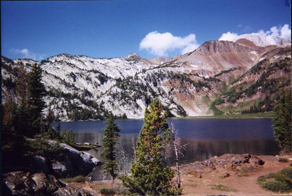
Ice Lake from the east shore.
Note the big boulder at near left;
Matterhorn at extreme upper right (gray slope);
and the puffy, white clouds.
I therefore decided to attempt the summit, weather permitting, that very afternoon. Then I could arise at dawn, hike down and be at the trailhead mid-morning just when businesses are opening for Friday.

To this end I reached Ice Lake just 3 hours 50 minutes from the trailhead. I pitched the tent, rested inside, and, daypack shouldered, was off for the summit just before 11 a.m.

The Matterhorn-to-Sacajawea ridge involved much class 2 with some class 3 sections that seem nearly unavoidable. I call Sacajawea a class 3 ascent. However as with elevation gain, because a class 2 route exists from the Hurricane Ridge trailhead, the current rules require that Sacajawea remain denoted a class 2 ascent. Personally I think that's ridiculous since, again, the majority of climbers choose the Ice Lake approach.

I reached the summit just past one o'clock, and, even though I desired greatly my lunch, decided to descend after just a few minutes due to gathering afternoon clouds.

I finally took a long lunch break at the 9,050 foot level where I had left the faint climber's path, leading to Matterhorn. It was here, on the ascent that I had commenced a cross-country route leading to Sacajawea via the 9,775 foot subpeak on the intervening ridge.

The "everything bagel" (studded with twelve kinds of nuts and seeds) never tasted better, much of it with canned, deviled ham and romano cheese. I made milk from water and the dry powder, all to wash down a large coconut granola bar.

from Sacajawea summit
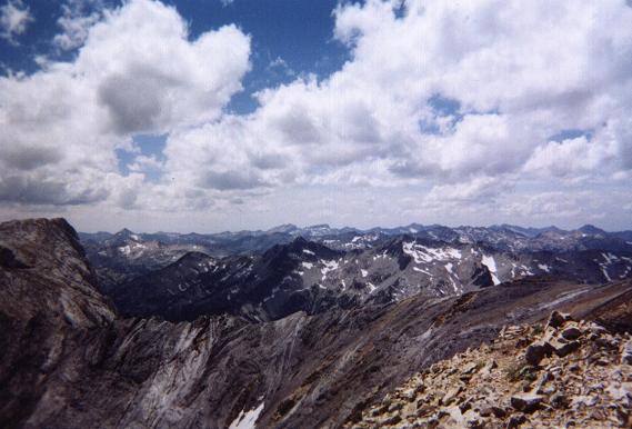
View southwest from Sacajawea Peak's summit
towards numerous mountains in the Wallowa Range.
Matterhorn is at far left, accessed via the
foreground ridge.
Back in camp by 3:36 p.m, I lay in my tent and read from some books on state and county highpointing. Dinner came around six, and I shared in conversation with a family of four camped nearby. I accepted their extra rice with "teriyaki" chicken and green beans, and for dessert made myself chocolate pudding with a final granola bar.

I spent a good amount of time exploring a big boulder at lakeside, as well as the outlet to where Ice Lake drains into Adam Creek - a most pleasing brook indeed that, lower down, supports a series of spectacular waterfalls.

Friday, August 6

I awoke at 5:42 a.m. fully aware that today would be a BAD day. I would have to deal with insurance people and auto repairmen - a most unsavory lot just a cut higher than lawyers and politicians on the scale of ethics and morality.

Back to my truck at 9:39 a.m., I immediately inspected my insurance policy and noted that I had comprehensive coverage. Did that include an elk attack? I nervously called my mother at a pay phone in Joseph (no small task getting my truck seven miles there!), and asked her to make the call for me while I got a soda pop from the market where I had parked - all of this amidst screeching noises from the undercarriage and multiple stares from onlookers.

An employee of the local auto repair garage shop directed me to a body shop in nearby Enterprise, six miles farther along the highway. Although I could have requested that my car be towed, it would have consumed much time and effort.

As I drove north on the only connecting road between the two towns, a line of cars began accumulating as I drove at the humble pace of 20-30 m.p.h. Finally a Sheriff's vehicle appeared in back, and, with lights flashing, forced me to pull over. After I explained the situation and suggested that the officer call ahead to the body shop as proof of my words, he examined my driver's license and was satisfied that I was doing a remarkably good job of driving given my truck's sorry state.

The body shop owner and operator was a former climber himself, and this topic formed much of our dialogue as I watched him slice away at the front fender, and perform other dastardly deeds of wanton destruction in an effort to make the auto roadworthy.

I road-tested the truck and was satisfied with its performance. Returning to the shop I exchanged contact information and then filled up on gasoline at a nearby station. A Safeway store provided a most enjoyable pint of Ben & Jerry's Cherries Garcia ice cream (actually, the lower fat, so-called yogurt variety - yet still loaded with precious carbohydrates).

Desirous of getting this awful day overwith, I drove just 107.6 miles to Baker City even though I arrived at about 6 p.m. with over two hours of daylight left.

Saturday, August 7

I had estimated 1,150 road miles from the Sacajawea trailhead to home. The suggested two day effort would be equitably split were I to spend the night in the Reno area. This I did, Carson City being the final stop of the day after 507 or 508 miles.

Sunday, August 8

The final 512 miles were driven today, arriving home by mid-afternoon. Adding the various distances, including an estimated twelve miles from the Sacajawea trailhead to the Safeway in Enterprise, gives a total distance of 1,140 miles from trailhead to home - including a few miles extra due to driving to/from the motel in Baker City (the motel in Carson City was right along the highway).

Adam and truck
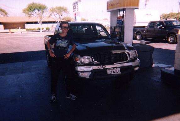
In Bishop, California at a fuel stop.
The ten mile discrepancy between the estimated (1,150 miles) and actual (1,140 miles) mileages is largely explained by the shortcut I took around Reno: traveling southwest on Interstate 80 from Winnemucca I took exit 48 and drove south on Alt 95 to Silver Springs, thence west on route 50 to Carson City.

The entire drive home featured a nagging concern that the front hood would blow up in my face - the front latch, although holding, had been forced to latch with a huge wrench at the body shop after the radiator assembly had been shoved forward with a crowbar to make clearance for the fan belt. Piano wire helped - but every time an auto passed in front of me, the turbulence created an undercurrent of air that caused the hood to rattle violently.

Cinder Cone
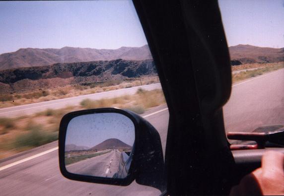
A prominent cinder cone appears in
the side view mirror along highway 395
north of Ridgecrest, California.
On the return to California I had originally planned upon bagging Sandstone Peak, the Santa Monica Range highpoint and on the California 2,000+ foot prominence list. However I felt it prudent to drive directly home given the state of my vehicle.

Summary

After 4,222.5 road miles in my truck, a record for myself, nine counties put my total county area at some 840,000 square miles. I now have the final western state highpoint behind me, apart, of course, from Mount McKinley itself.

I plan to complete Utah on my next trip. I also will climb some good mountains in the San Juan Range of southwestern Colorado with Edward Earl, getting there as his passenger since my truck will likely still be in the body shop.