Colorado September 2005 Trip Report
© September 2005 Adam Helman
(Click on any image for enlargement.)

Background

This journey was a key component in my ongoing desire to reach the highest point of every county in Colorado. The initial plan was to spend an entire month highpointing on a single trip from California in order to lower the transportation costs - expenses now larger than ever due to excessive gasoline prices.

I split the effort into two separate trips because after one month I would be ticking peaks off a list rather than actually enjoying them. The current journey was the second trip, and was planned as roughly two weeks duration. Nine counties were contemplated as displayed on this route map.

I met John Hamann of Albuquerque, New Mexico for the first three mountains, all located in the eastern San Juan Range.

Trip Details

Saturday, September 3

A summertime road trip from San Diego to southwestern Colorado necessarily travels through desert country when temperatures are intolerably hot - particularly for attempting to sleep in a camper shell. Therefore I planned to camp at the 7,000 foot level of Sunset Crater National Monument just north of Flagstaff, Arizona and off of route 89 as it wends past the San Francisco Mountains.

My specific site was going to be on a Forest Service road a few tenths of a mile south of the main loop road that takes one, over 32 miles of pavement, through both Sunset Crater monument and nearby Wuputki National Monument. This favorable site is perhaps one mile directly east of Sunset Crater itself - the latter currently off-limits to hikers due to concerns about the resulting deterioration of crater features. The site was a good one on the previous journey because there is absolutely no water to be had - and thus mosquitoes are completely absent. Staying at 7,000 feet would also provide me a measure of altitude acclimatization. The driving distance from my San Diego home is 510 miles, starting with I-8 to Gila Bend, Arizona.

Unfortunately this was Labor Day weekend, and literally dozens of RV campers and ATVers were in force. I could not tolerate their noise; drove back to the main road; and camped one-half mile farther east on a dirt side road that, nonetheless, was the venue for more ATV addicts clear through the evening - even after sunset.

Evidently my good campsite merits attention only on weekdays when solitude prevails.

Sunday, September 4

I drove highway 160 past Four Corners and into southwest Colorado, passing through, in turn, Cortez, Mancos, Durango, and Pagosa Springs. Durango by this route is 810 "Adam truck miles" from my home, with Pagosa Springs sixty miles farther still. An Adam truck mile is perhaps one-sixtieth part longer than a standard, statute mile - and corresponds to the odometer reading in my green Toyota Tacoma.

I was to meet John Hamann at the trailhead for Archuleta Peak - the Summit County highpoint. As I drove along the Forest Service road I recognized his black Tacoma with New Mexico license plates. John had just climbed Vermilion Peak that weekend, along with nearby Fuller Peak and Golden Horn. We had independently taken the (same) obvious approach from the west.

We caravaned to the trailhead - a simple turnaround at road's end and at 10,980 feet according to both the map and my GPS unit. This is a lofty elevation even for a Colorado trailhead.

The evening was uneventful except for some slight drizzle just after sundown.

Monday, September 5

The morning featured overcast skies. The initial route plies through dense alpine forest on a narrow path. Owing to the dark skies and the dense vegetation, we simply waited fifteen minutes after breakfast before making our exit at 6:28 a.m.

The ascent of Summit Peak was successful. That said, the climb would have been more enjoyable had the weather cooperated. Details are provided in this trip report.

We returned to our vehicles around 11 a.m. and placed into motion our plan for a second highpoint that afternoon - Conejos Peak of Conejos County. This peak was clearly visible as the most prominent object on the southeast horizon from our morning summit perch.

The Forest Road approach consumed far more time than anticipated - some 1 1/2 hours to negotiate roughly twenty-five miles of road - even though the air distance between the two peaks is only an estimated eight miles.

The trailhead for ascending Conejos Peak has been relocated by the Forest Service. Details of this feature and of our successful Conejos Peak climb are provided in this trip report.

We slept nearby at an offical campground, having felt no need to drive towards the next day's venue because Bennett Peak would consume only the morning hours.

Tuesday, September 6

Bennett Peak is the Rio Grande County highpoint. The road approach is from either the north or south, with both options converging at 11,700 foot Blowout Pass. The south approach was far more convenient given our location, and we selected this route despite reports that much of the road is quite poor.

Details of this drive and of our successful Bennett Peak climb are provided in this trip report. The "crux" of this effort is the driving approach - not the short summit hike.

John was not feeling well. He decided to call six peaks enough on this trip and drove home after we returned to FR250 from Blowout Pass. I drove to Monte Vista, and, around 2 p.m., enjoyed a pint of ice cream in the Safeway parking lot, in the truck cab and facing northeast with the A/C "on" to minimize melt.

The original plan was to polish off the four eastern San Juan Range counties by climbing unnamed 13,895 feet next - the Mineral County highpoint. However Monte Vista was due south of the venue after Mineral - Bushnell Peak of Fremont County. I was farther east than anticipated because FR250 had taken me well east of Bennett Peak on the drive out to the paved road system. Thereby I decided to attempt Bushnell Peak first, so avoiding needless east-west driving.

I drove north on Colorado 285 through Saguache, turned northeast, passed through Villa Grove, and eventually camped near the trailhead for ascending Bushnell Peak, by the western approach, as recommended in Dave Covill and John Mitchler's Colorado Highpoints guidebook. In truth I had driven 0.5 mile up the rocky road normally walked at the beginning of the hiking route in order to shave-off some distance and elevation gain for the next day's effort. Even with this maneuver I was faced with 4,500 feet of gain - a full day.

I do not recommend driving this road - the opportunity for tire puncture outweighs the resulting savings in hiking time and distance.

Bushnell Peak
Bushnell Peak and Raul.
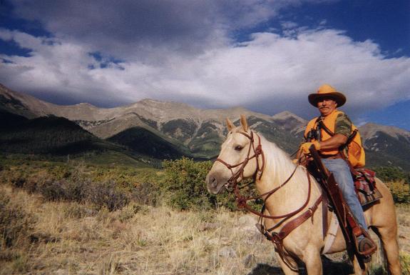
Note the Bushnell brand binoculars.
Before sunset a man on horseback sauntered down the road and greeted me. He was hispanic and carried pistol, bandolero, and a rifle slung over the side. Raul was bear hunting. He did not find any that day - nor did I inquire as to the legality of this activity. I took his picture with my camera, and then took two pictures on his digital camera as per his request. He invited me to sleep at his nearby, lower camp. I declined because it would mean driving back up in the morning - a most inconvenient plan given my goals.

The great San Luis Valley lay to my south, one that I passed through that afternoon from Monte Vista, and seen from on-high that morning from Bennett's summit. The Crestones and the Blanca Peak massif were visible along its eastern flank, both areas under attack by a deluge of rainfall.

Closer at-hand I enjoyed fine vistas of the valley's northern extension - one bounded to the northeast by the Sangre de Cristo Range, and to the west by high mountains in the Rio Grande National Forest.

Automobiles formed a narrow bead of lights as they plied Route 285 northwest and southeast along the midline of this local extension of the San Luis Valley.

Wednesday, September 7

A cloud ceiling hung at 12,000 feet, precluding views of the summit ridge along the spine of the Sangre de Cristo range. The cloud cover did not shift more than a few hundred feet, in either direction, as I hiked the jeep road to its end at 10,800 feet.

There are three stream crossings along the jeep road. The second crossing is tricky and caution is advised at this point of the effort.

Caching a liter of water at 10,700 feet, I then struck out southeast for an intercept of the southwest ridge of Bushnell Peak. As anticipated the route was steep indeed. I found the going easier, and safer, by concentrating on the grasses in preference to the scree and rock outcrops.

I hit the southwest ridge at 12,000 feet, and, with a journey through the clouds at-hand, donned my raingear and gloves before striking out uphill - this time northeast up the (quickly disappearing) ridge.

Above 12,600 feet one is advised to trend slightly south of the northernmost (left edge) portions of the southwest ridge. The rocks are smaller, less frequent, and often interspersed with grasses immediately to the south (right) of the actual ridgeline.

The summit ridge wafted in-and-out of view as the sun desperately tried to burn off the morning cloud layer. I received enough of a glimpse to avoid climbing a prominent rock face about 200 feet beneath the summit and directly on the southwest ridge. Contouring around this rock buttress, I gained the main ridge just as the clouds lifted! I walked the 100 remaining feet, with minimal elevation gain, in sunlight for the first time since my departure.

Views were spectacular in all directions. Multiple ridges trailed away from the summit - not just to the northwest, southeast, and southwest - but also to the east and northeast. It was like being at the center of a 5- or 6-way street intersection.

I had taken 3 hours 50 minutes for the ascent. After a satellite call to mother I decided to descend immediately lest the clouds return and render more difficult the navigation along a reverse course.

On descent from the southwest ridge to the jeep road's end I found a shiny, sparkling rock festooned with a silver colored mineral at about 11,500 feet. I wrapped the stone, perhaps three pounds, inside my raingear, and continued descent. I have yet to identify the material and hope that it is something "more" than simply mica. To occupy my thoughts I dreamed that it was a nugget of platinum - and that I might fetch a high price for it by donation to some famous museum.

The round-trip elapsed time was 7 hours 32 minutes. A green Forest Service truck drove by while I was napping in the driver's seat. The man was exploring as part of his standard patrol, and we had a lengthy conversation about county highpointing.

I had a headache as I drove south along Colorado 17 to Alamosa - one that was relieved in part by finishing a cache of rocky road fudge for its sugar content. I rented a motel room in Alamosa that afternoon, enjoying the shower and much television. A sore throat bothered me, yet I did not pay much attention to it.

Thursday, September 8

I was sick today. Fortunately I had planned to spend the day sightseeing. After driving to Great Sand Dunes National Park I only wanted to sleep in the truck's camper shell. Somehow I enjoyed the Visitor Center followed by a nap in the parking lot for various dune hikes about 1.5 miles north. I just did not have the desire to leave the lot and actually "do" something.

An ice cream fudge bar heightened my spirits as I drove southbound to Alamosa. The Blanca Peak massif was very close by, to the east, and I admired it as much as I had the entire Sangre de Cristo range the previous afternoon along Colorado 17.

I drove on Route 160 to South Fork and then the 22 miles northwest on Route 149 to Creede - the nearest town for access to the highpoint of Mineral County.

I investigated the driving approach, poking around with my truck at possible places to park the next morning. A pounding headache alarmed me as I climbed all of ten feet up a gravel mound to peer over its top. I drank two V-8 juice cans and found that it partly alleviated my sense of uneasiness.

It started to rain. How could I possibly consider sleeping that night in near freezing weather, at nine thousand feet, and expect my health to improve? I investigated motel options in Creede, learning that only bed and breakfasts were in-town - with a minimum room price of $110 for the night. That was well beyond what I was willing to pay.

This was the emotional low point of my journey. I was coughing, had a sore throat, no place to stay, and it was raining. I called my parents to inform them I was driving home. I returned to South Fork and took a $50 room there, and no farther west along Route 160, in the outside chance that I would feel better the next morning.

Friday, September 9

I DID feel better! Arising at 5:20 a.m. I checked the sky and found it clear. I walked twice up a flight of stairs and noted no headache.

Some hunters in the next room over had also awakened 1 1/2 hours before sunrise. I had a short conversation with them, figuring they were kindred spirits in the limited sense that they too enjoyed the Great Outdoors - and also had the perceived need to avoid afternoon storm activity through an early start. There were four hunters - three men in their forties and one very skinny, blond teenager who is likely one of their sons. All were dressed in olive and tan khaki.

Details of my successful "unnamed 13,895" climb are provided in this trip report. Mineral County was my fiftieth Colorado county highpoint - a milestone of sorts. Mineral County also realized my goal of completing 70% of the counties in the entire eleven state contiguous western United States by summer's end - 290 of 414 counties.

I was pleased that I succeeded with this effort despite illness. I drove northwest on Route 149, camping at high, 10,898 foot Spring Creek Pass along the Continental Divide.

Pass kiosk
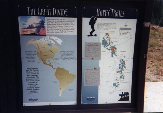
A descriptive kiosk at
Spring Creek Pass.
While enjoying supper at the lunch table of my campsite I had some fun with the bird life. They were obviously interested in my food. What could I part with? My barbecue-flavored "Soyitos" chips were delicious and full of protein. I placed five of these triangular treats at table's far end - and watched them get eaten one-by-one as birds, a flight "sortie" at a time, landed in turn for their piece.

A slice of whole wheat bread was next. Amazingly, I witnessed a bird, the size of one's hand and just a pound by weight, snatch the square piece by the corner and fly off, bread dangling from the beak, and into the shelter of a nearby tree. This feat is analogous to a person snagging a large pizza by the teeth and flying across the street to a third floor apartment room! A second slice of bread met with a similar fate.

I cleaned the table from supper and hid away within my camper shell for the night. Right on schedule, a light drizzle dampened both ground and spirit at sundown. It was as if the solar heating, suddenly absent, was no longer available to support the afternoon's moisture-laden clouds. The latter then dump their load as if on cue.

A considerable thunderstorm ensued that night - expected activity for a high pass in the Colorado high country. In fact, my experience is that the San Juan range is permanently mired in precipitation of one form or another. How anybody could live there and actually enjoy it is beyond me. The saving grace, of course, are the mountains and their vistas.

Saturday, September 10

I could easily have made today a sightseeing day - especially with Black Canyon of the Gunnison National Park so nearby once I got onto Route 50 near Gunnison. I was sick and there was no rush to get home because I had no proverbial clock to punch.

But Oh Nooooo! - my inherent "A-type" personality came through once again. I just "had to" consume the entire set daylight hours with more driving and climbing.

It started at 5:20 a.m. with the sound of light rain, or snow, on the camper shell roof. Startled by the thought of snow at a high pass, I imagined the worst case scenario of being stuck there until a road crew plowed a path to safety. With headlamp trained at the ground I was relieved to find none of the white stuff.

Unable to sleep further, I started driving north on Route 149 well before sunrise, eventually stopping 30 miles shy of Highway 50 to sleep one blissful hour in the shell. I then continued driving, making a right turn (east) onto Highway 50, taking myself out of the way for the next venue, to secure gasoline and hot chocolate at nearby Gunnison.

At a Love's station I paid the (now typical) $2.999 per gallon for regular unleaded. Just down the street, and only one block away, a Phillips station sold the same product for $3.399 per gallon - at forty cents, the largest price difference between competing stations that I have ever witnessed.

A Mississippi Mud Pie ice cream sandwich with coffee adequately satisified my hot chocolate craving - after all, this food pairing features the same desirables of hot beverage and chocolate - only packaged in a different manner! The caffeine did not hurt either...

I drove through Montrose and headed south to the Ouray County line; thence east for access to Castle Rock - the Montrose County highpoint.

I must say that the bushwhack from the (southbound) Forest Service road to a gap in the main north-south ridge is most tedious and unenjoyable. I accessed the ridge perhaps 100 horizontal feet farther south than ideality would suggest - climbing a 50° slope of hardened mud by using embedded tree branches and roots for hand and foot placements. Once atop the main ridge I peered down the 20-30 foot slope and said, "Gee, I climbed THAT?!".

The only saving grace of this effort was the view once atop Castle Rock. The approach road can be muddy; there is a steep section to the use trail immediately north of Storm King's summit; and that bushwhack is memorable.

I returned to the same Montrose motel, the Blue Skies, where I had slept on two previous journeys - around Labor Day weekend in 2004, and in August. The manager is British, intelligent, and maintains a good yet reasonably cheap establishment about one or two miles north of city center and along the east side of route 550.

The summer monsoon had finally abated - which allowed me to climb Castle Rock in the afternoon. Thereby it was "OK" to take a room for the night two hours drive from the next day's trailhead - for Mount Lamborn - since a dawn start was not needed. My illness also played a major role in this decision to sleep in a bed, at 5,800 feet, instead of at a high and cold trailhead.

Sunday, September 11

Today I climbed Mount Lamborn, the Delta County highpoint. Details of this successful effort are provided in this trip report.

In Crawford I enjoyed a Butterfinger ice cream sandwich and considered whether to drive all the way to any of a number of campgrounds near Leon Peak, for the next day, or simply drive to nearby Delta for yet another motel room.

Needle Rock
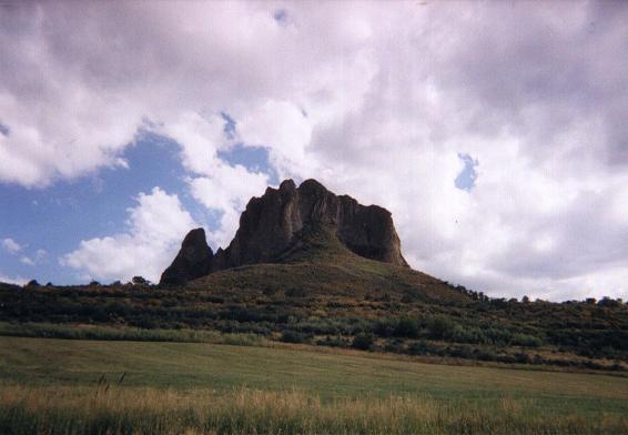
Needle Rock is featured
enroute to the southern approach
for Mount Lamborn.
I chose the Delta plan for the same reasons as noted above - it would be better for my health, and, due to the waning monsoon, it would not provide an obstacle to the timely ascent of Leon Peak. Finally, I would arrive at the campgrounds no sooner than 7 p.m. - leaving insufficient time to prepare supper by daylight. I do not enjoy preparing and eating supper in the dark - it lends a sense that the day's schedule was too packed for what is supposedly a "fun time".

Monday, September 12

Today I climbed Leon Peak, the Mesa County highpoint. Details of this successful effort are provided in this trip report.

I concluded my ascent at 12:21 p.m., and, with several hours of available daylight, drove to Richfield, Utah near the western terminus of Interstate 70. Richfield was the optimal end point of the day's efforts because it resulted in a 600 mile road journey to San Diego - an amount I consider to be a full day of driving without reaching the point of exhaustion.

Tuesday, September 13

I enjoyed a full breakfast in the motel lobby - everything from english muffins with honey and peanut butter to hot chocolate with marshmallow bits.

The trip "B" odometer (zeroed that morning) read 601.1 miles on return home.
The trip "A" odometer (zeroed at the journey's start) read 2,602.3 miles.

Summary

I had attempted eight of nine counties originally planned - the difference, as Vermilion Peak, being considered "optional" in my thoughts from the onset. Vermilion was cancelled because, unlike the journey's "must have" county highpoints, and especially given my illness, I felt no special compulsion to climb Vermilion Peak. It could certainly wait until the next summer. In contrast, I was compelled to climb the remaining mountains, despite illness, in order to remain synchronized with my overall Colorado completion plans.

Bushnell Peak was also an "optional" summit. However Bushnell Peak was climbed because I was healthy when the "number came up" for climbing it.

All eight county highpoint attempts were successful. I have now visited fifty-three of the Colorado county highpoints, with ten of the remaining eleven counties planned for next summer.

Eight additional counties raises my total county area to some 975,000 square miles. The resulting completion map indicates these eight counties with blue "+" signs.