Nevada Prominences March 2012 Trip Report
© March 2012 Adam Helman
|
|
|
Note 1: All coordinates use the WGS84 datum.
Note 2: Photographs are courtesy of Andy Martin.
Note 3: Mouse-click most images for detail.
|
Dynamic Trip Map
|
Background
A random comment in an E-mail sets this in-motion - with reference to my
recent Mexico ultra-prominence expedition
I note that, although few venues of mutual interest remain there, I would in contrast enjoy
peakbagging in Nevada with Bob Packard and Andy Martin who missed-out entirely with Mexico.
Andy immediately suggests a prominence-based trip a mere week-or-so later set for President's Day weekend
in mid-February so as to diminish required vacation allowance. Clearly he is most eager to do something!
I consider this weekend and submit that going in March is the more weather and snow-savvy concept.
Then Bob Packard comes home from one of of multiple trips bagging P300 summits in Cochise County, Arizona -
writing that he's not aware of a trip he's planning to Nevada!
Eventually we agree to a mid-March timeframe for a pair of four P2000 peaks, the tentative driving day Friday, March 16
since Bob has choir rehearsal in Flagstaff on Thursday evenings and wishes to miss just one of them.
Then too Andy obviously wants to climb the four peaks he's not done with a weekend overlap.
So the plan is for all three of us to do Andy's peaks first. He'd go home while Bob and I do the remaining four.
[Historically my off-season prominence trips have included 4 or 5 mountain climbs. With ever-rising gasoline prices
it makes more sense to double the peak count (hence 8 total) while halving the frequency of such efforts.]
Friday, March 23 is set as backup plan if the forecast calls for shabby weather from March 17 onwards.
It's not just rain: snow is quite feasible at the relevant elevations. Although that's OK for the hikes themselves,
getting stuck at a "trailhead" with snow precludes mechanized exit to the outside world ... until it melts.
To raise the chances of a fair weather window I propose an alternative wherein Bob and I do the "second" set of
four peaks first, starting on a Monday, and then meet Andy Friday afternoon for the "first" set.
A significant storm brings rain to California and snow to the Sierra Nevada over the primary weekend -
and its track passes through both Nevada and Bob's Flagstaff home with near blizzard conditions.
However I see a string of several fair weather days in the long-range southern Nevada forecast.
Wishing to leverage that opportunity I propose that Bob and I drive on Tuesday the 20th (Flagstaff is forecast
to have a 70% chance of snow througn Monday so Bob cannot leave then). However that means only three days
to do four peaks prior to meeting Andy Friday afternoon (Wednesday through Friday). I request that Andy meet us
on Saturday afternoon instead - and he kindly agrees. Finally, Bob should be able to get home prior to
his Thursday evening choir rehearsal on Thursday the 29th.
Andy will bring his wife Sarah.
|
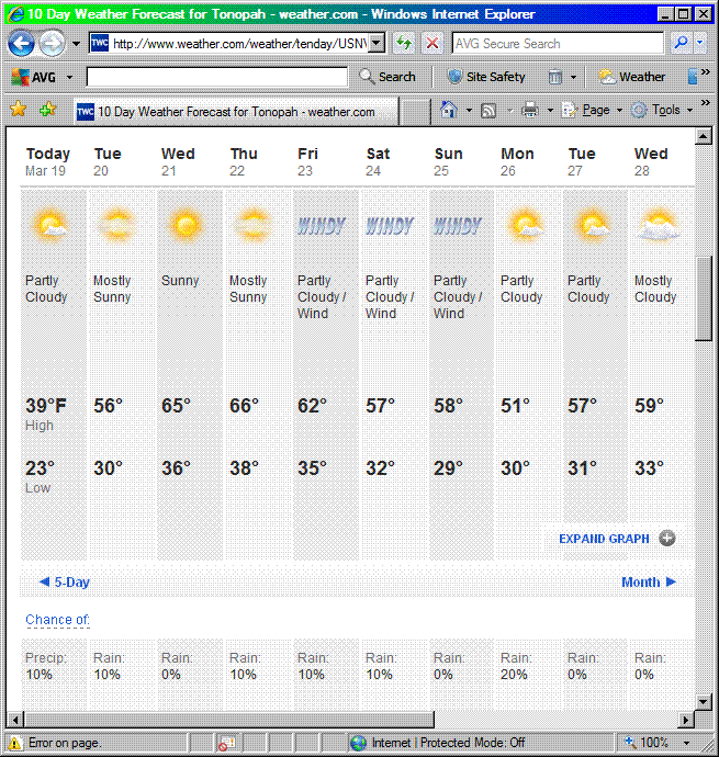
Ten day Tonopah, Nevada forecast from Monday, March 19
suggests an excellent window of opportunity.
|
Trip Details
Tuesday, March 20 - to Nevada
Bob leaves Flagstaff Monday evening yet I am unaware of this prior to meeting him in Beatty, Nevada
at this most unusual store / gasoline station around 3:10 p.m. He's already done three P300
(300+ foot prominence) summits - a pursuit not shared by Andy and myself. The store has twisted brick
columns and sells a huge variety of sweets and nuts. There is an embedded Subway outlet
and an ice cream parlor.
Bob has a cough and says that it was "given" to him by a grandson. Unfortunately we have already talked
directly to each other so his warning to be aware of this issue arrives too late. I become sick
the day I drive home, taking several days to recover. This 8-day incubation period corresponds
exactly to how long it took Bob to contract his illness.
With plenty of time we head for the first trailhead. Bob has prepared route information for this set
of four western peaks - myself the eastern four. At a key road junction we turn the wrong way,
and waste two hours trying to reach a trailhead unattainable by vehicle from our location.
What happened? A combination of oversights caused this mess.
- This posted trip report
fails to note that at 4.6 miles from pavement the main road veers left and descends to the northeast.
Instead, one must continue on the narrower side road straight (south) to the 4.9 mile junction noted. 1
- Bob did not bring any maps for the approach drive of sufficient scale to assist in the effort.
He does have the Nevada DeLorme atlas - but at 4 miles to the inch it's insufficiently detailed.
With waning daylight we backtrack to the cited junction, turn south onto the lesser road, and find
Dennis P's instructions on-target.
This evening I use my own utensils for supper, designating a pot and plate that only I will employ
for the journey's duration.
It's the only measure I can still take which might
prevent contracting Bob's illness.
1. At 3.2 miles from pavement is a Y-junction. On departure take the left fork.
Wednesday, March 21 - Bare Mountain
We diverge from posted routes both on the ascent and descent. There are several permutations which "work",
and no specific method is preferred hands-down.
Back after about four hours we return to Beatty for ice cream. I also purchase a one pound bag of
cashews with a toffee crunch exterior: it's excellent, used as a flavoring agent for many sweets over
the entire journey - ice cream, hot oatmeal, chocolate cake and all-by-itself.
We use my truck to visit Rhyolite, a ghost town 6 miles west. Then we visit the Beatty Library to obtain
viable printed maps for the driving approaches and hikes in our remaining set of western Nevada peaks.
With these maps in-hand we easily reach the desired car-camp for our next venue.
Thursday, March 22 - St
X
one
X
Wall
XXX
Mountain2
The 1.2 miles from our car camp to the desired "trailhead" is designated 4WD ("four wheel drive") on the
topographic chart. Indeed. I make room for Bob and eventually park in a gravel stream bed slightly short
of the track's actual end.
The trip report Bob could find is appallingly inadequate, written by a UFO / alien freek interested in
peering into the not-too-distant Area 51 from a nearby subpeak. I claim that without the maps we just obtained,
along with coordinates for key landmarks keyed-into my GPS unit, that we would have not reached the summit.
Here are some waypoints to reproduce our effort.
| Description |
(latitude, longitude) |
topo chart (waypoint at cursor) |
| ********** |
**************** |
************************* |
| end of 4WD track |
(37.54274° N, 117.04684° W) |
click here |
| pass 6,000 feet |
(37.53546° N, 117.04310° W) |
click here |
| end of [unfound] pack trail |
(37.52287° N, 117.04147° W) |
click here |
| pass 7,000 feet |
(37.51946° N, 117.04001° W) |
click here |
| saddle (7,660 feet) |
(37.51531° N, 117.04122° W) |
click here |
| end of sidehilling |
(37.51071° N, 117.04426° W) |
click here |
| peak 8300T |
(37.50489° N, 117.04413° W) |
click here |
| STM |
(37.50006° N, 117.04001° W) |
click here |
The topographic chart's "PACK" trail is no longer helpful.
We encounter much snow from 7,000 feet up a moderately-angled gully south-southwest to the
indicated 7,660 foot saddle - enough for gaiters and an ice axe.
At that point there's no need for going over peak 8142T.
Sidehill around its southeast slope, gradually losing 50 feet elevation. Then climb south to
subpeak 8300T with communication gear. Finally ridgewalk to the desired summit with a 100 foot dip.
Bob and I take 7 1/2 hours for the round-trip.
This evening we camp on the south slopes of our next peak at 7,800 feet elevation.
2. Mangling of this mountain's name is intentional to foil web crawlers.
Within the text it is denoted "STM".
Friday, March 23 - Blue Dick benchmark and Gold Mountain
I realize there's a small chance that snow on its approach drive will prevent us from hiking
Gold Mountain on Saturday morning with enough leeway for meeting Andy at 4:30 p.m. after a 200 mile drive
north (through Tonopah), east and southeast. Thereby I propose to Bob that we drive as high as feasible
for Blue Dick - leaving us enough time for doing Gold Mountain this very afternoon.
Our camp is 1.0 road miles north of
this junction
at the 7,800 foot contour. With Bob as passenger I drive to
this junction at 8,700 feet.
Snow blocks further progress to the next junction with a 50 foot section of road
completely covered in the stuff - yet Bob feels I should give it a try.
In four wheel drive the car is shoved into the snow ... and promptly stops halfway in!
Not willing to experiment when the negative consequence is so severe I back-out and reverse downhill
to park at the 8,700 foot junction. From here we walk.
The road heads steeply uphill, eventually passing right over
peak 9231 T before heading
east to the true summit. It is only about 8 a.m. and the wind is very strong from the south as I walk
the intervening distance. My nose is freezing! Bob soon arrives at the highest ground and we leave
shortly after due to conditions.
The drive to Gold Point (population 27) is uneventful. Just 0.3 mile outside town I hear strange sounds -
and stop to learn my left rear tire is completely flat. Bob has driven away, unaware that I have
stopped because his camper prevents a good rear-facing view. Rather than fix the flat now I recommend that
we bag Gold Mountain and then return to replace the tire this afternoon.
This posted trip report
is quite adequate for Gold Mountain. However at the
cited saddle
with odometer mileage 12.3 the situation is more complicated than described.
Here the main road switchbacks from south-southeast to northeast. From that road spouts TWO
minor roads - one heading west and the other heading south. You want to drive or hike the southbound road
which eventually winds around to the south side of spot elevation 7632 feet. Do not take the
westbound road which remains on the north side of the main ridgeline.
Bob and I effect the tire replacement by 2:30 p.m. - and it takes longer than expected because of various
inconsistencies in what I can provide as tools and what is truly required. Surely I will be purchasing a
four-way lug wrench...the act of standing atop the available tool perhaps inadequate for the final bolt-tightening
given my slight build. As-is we have to use Bob's tool.
We drive into Goldfield, Nevada and learn of a repairman one mile north on the highway.
Although he patches the bad tire he claims the rock made a 1 1/8 inch rip - too big for guaranteeing
that a similar incident will not readily re-flatten it.
However there is no (completely new) tire of the proper size for purchase.
So I keep the (slightly too large) spare as the left rear tire,
and consider how my odometer will be "off" as a result. The repaired correctly-sized tire is my spare.
With a cell signal just outside town we camp only 5 miles north, reserving Tonopah for early next morning.
Andy corroborates the repairman's snow for Monday, will indeed be coming with Sarah,
and my mother also hears from me.
Saturday, March 24 - desert rendezvous
In Tonopah Bob gets milk at the market, myself a package of raspberry fruit bars after having the usual
hot chocolate / coffee drink. It's about 130 road miles to our
rendezvous point with Andy.
Before then, however, Bob climbs a roadside 1,000+ foot prominence while I wait in Rachel, Nevada
providing waypoints to my GPS unit for the remaining efforts. Rachel lies along Nevada Route 375 -
the so-called "Extraterrestrial Highway". It is a tiny community with little to recommend it.
Andy arrives with Sarah at 3:30 p.m. - an hour early. We caravan as three vehicles to a windy saddle
used as trailhead for Mount Irish the next day. Tonight I prepare pasta with Cajun spices, kosher salami,
and plenty of whipped butter for Bob and myself. It's deeeelicious!
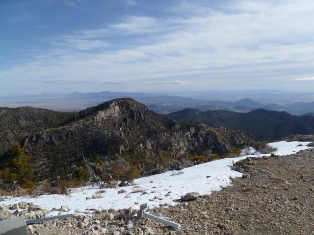
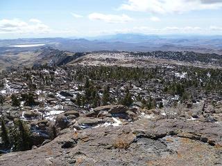
Sunday, March 25 - Mount Irish
|
View north from Mount Irish summit
to the 'extra' P300 peak Bob climbed.
|
Another windy morning. Bob leaves at 6:30 a.m. before sunrise as he aims for an additional P300 summit
nearly a mile beyond the day's main goal. Andy, Sarah and I leave around 7:35 a.m. - and consume about
4 1/2 hours for the round trip. By 12:30 p.m. Bob comes around - and we agree to join Andy at the
US Route 93 / Nevada Route 375 junction.
Here, Andy is concerned that his Honda Accord might get stuck
in snow by taking the (shorter) eastern path - yet Bob and I encounter no snow whatsoever.
With just one-half tank each, Bob and I drive south intending to fill at Alamo. Fortunately Ash Springs
just 4.7 miles south of the cited junction has a Shell station! After ice cream sandwiches and
(for myself) caffeinated "diet Dew" we return to Andy and Sarah.
I propose that we drive to a trailhead for Hyko benchmark even though it could mean getting
snowed-in until it melts. That's OK, I explain: even if we cannot drive out until Tuesday morning we'd
still be on-schedule with Chokecherry by mid-morning.
So we drive east on Route 93 and then south some 11 miles to a 5,950 foot camp very near our
desired trailhead.
With a new stick of butter from Ash Springs I prepare the same pasta dish for Andy and Sarah -
followed by cappuccino Babka - a rich, walnut-crusted chocolate loaf cake for dessert.
It snows at 11 p.m. - yet just an inch accumulates. It's not enough to preclude our timely driving-out
when desired.
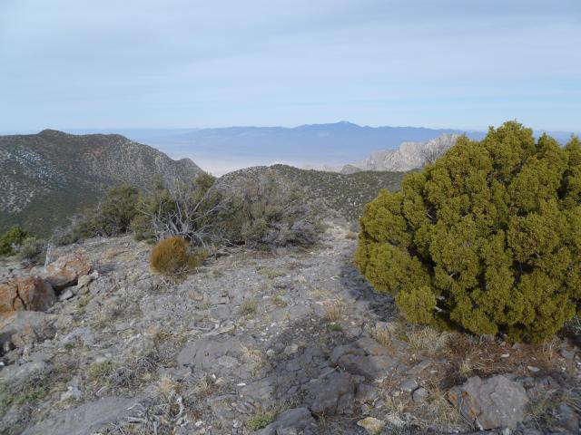
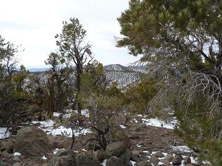
Monday, March 26 - Hyko benchmark in South Pahroc Range
|
|
View south from Hyko benchmark.
|
It's odd to see Andy's car (and mine as well) in a layer of white. Still, it begins to melt just as the sun
gets around to that task. However the ridgeline remains ominously cloudly. Andy suggests that we wait until
10 a.m. before starting - not the least because it allows for the snow to melt a bit.
Eventually we begin around 9:20 with Bob ferrying people to the road's end about 180 feet higher.
Our ascent route does not gain the high plateau
here as did Dennis Poulin.
Rather, we climb more steeply northwest to reach this level area about one-eighth mile north-northeast.
On the descent we aimed for the same point - so saving one-quarter mile of travel with no perceived downside.
The final one-third mile is through a maze of boulders and trees with much snow underfoot.
I go into "hyperdrive", unwilling to wait any longer for others, and summit the final rock massif
on its east side via a 7 foot Class 3 chute. My shouts of "Whooo hoooo!" are doubtless heard by the others.
Everybody is down by 2 p.m. After a hasty yet tasty herring sandwich with Dijon mustard I'm ready to drive,
as are the others, just before 3 o'clock. Our goal, of course, is a suitable trailhead for Chokecherry.
To that end we caravan to
this junction.
Then Andy and I go with Bob's vehicle about one-third mile up the northeast-bound track
to designate a morning trailhead at 6,600 feet. Finally we caravan to a good campsite
1.1 road miles back northwest on the "main road".
Tuesday, March 27 - Chokecherry Mountain
By 6:45 a.m. we all drive to the indicated junction, whence Bob takes all four of us in his vehicle
with Sarah locked-into the camper! We walk at 6:55.
There's plenty of snow on the north sides of two subpeaks enroute to Chokecherry proper.
Andy punches-through once, and eventually Sarah does too. Somehow I never suffer this fate - one which
is a function of pressure (hiking weight / boot area) and not simply one's weight. As I take only a
size 7 shoe this surprises me.
|
The slightly lower bumps viewed
from near spot elevation 8035.
|
We catch-up with Bob who, having taken a slightly different route gets there before the three of us.
Then too, consuming time, Andy hand-leveled the possible P2000 contender - an 8,000+ foot "blip"
alongside spot elevation 8007, from the 8,000+ foot subpeak immediately southwest of Chokecherry.
He determines that it cannot be higher than the 8,035 foot spot elevation -
so ruling out the "need" for visiting it.
I pass by Bob's vehicle at 11:02 a.m. and change clothes back at the junction a few minutes later.
Rather than wait for others I drive to Ash Springs to top-off the tank, call my mother (there is no signal -
a credit card call is used with a landline as was done two days before), and have lunch with a
"smoky link" hot dog topped with onion and mustard, orange soda pop, raspberry fruit bar smeared
with peanut butter and a raspberry ice cream bar coated in chocolate. I should've had two dogs -
having just one left me desiring another as I filled a perceived emptiness with junk instead.
It's just 2:30 when the others arrive. So Andy suggests an alternative approach to Badger Mountain
that goes by a driveup summit opportunity that gets Bob yet another P300 for the trip. We agree to try it...
however note that some sections are steep.
This alternative approach begins on US Route 93 about two miles north of Alamo, Nevada at
this junction.
The following road log is then applicable with distances in statute miles. Add about 1/36th part to all
values since the spare tire's larger diameter created an under-reading of true distances.
- 0.0 Route 93.
- 0.1 Turn right.
- 0.8 Turn left.
- 5.1 Turn right.
- 5.6 Turn left.
- 6.2 Turn right.
- 10.9 Junction with summit access road for driveup peak. Continue south.
- 13.0 Y-junction on exit whence bear left.
- 15.9 Junction cited as 18.3 miles from Route 93 via Madsger Pass.
Turn right and continue northwest to trailhead as per existing reports.
At the 10.9 mile junction (adding 1/36th yields a more correct 11.2 miles) Sarah becomes Bob's passenger
while Andy becomes mine. The summit road gains about 500 feet, leading to a communications facility.
Andy places a register at the base of an obvious boulder which appears to be the highest natural ground.
My herring jar serves admirably (after a thorough cleaning), the original contents placed in a tupperware.
We dub this peak "Repeater Hill".
I obtain a GPS-measured 6,177 feet elevation at WGS84 (37.34417� N, 115.25772� W).
For Badger Mountain Andy coaxes his vehicle fully 3.8 miles beyond the 18.3 mile junction at (37.31506� N, 115.29709� W)
which is NOT shown on the topographic chart - only on satellite imagery. Thereby everybody is
able to camp very near this point
at 6,890 feet a few tenths-mile northwest of "Badger Spring".
The wind has ceased and I look forward to a morning free of this annoyance.
Wednesday, March 28 - Badger Mountain; home
A modified route is taken relative to posted reports to lower the total distance, elevation gain and hence effort.
The following waypoints are instructive.
| Description |
(latitude, longitude) |
topo chart (waypoint at cursor) |
| ********** |
**************** |
************************* |
| camp |
(37.35003° N, 115.34494° W) |
click here |
| leave road |
(37.35248° N, 115.34537° W) |
click here |
| northeast up ridge |
(37.35392° N, 115.34270° W) |
click here |
| end of ridge section |
(37.35410° N, 115.34092° W) |
click here |
| saddle |
(37.35509° N, 115.33900° W) |
click here |
| bottom of descent |
(37.35698° N, 115.33582° W) |
click here |
| ridgeline bump - rocky |
(37.35680° N, 115.33245° W) |
click here |
| summit ridge - antennae |
(37.35685° N, 115.32615° W) |
click here |
| Badger North |
(37.35368° N, 115.32614° W) |
click here |
| Badger |
(37.35157° N, 115.32602° W) |
click here |
Get from "end of ridge section" to "saddle" by sidehilling northeast.
From "saddle" to "bottom of descent" is a GPS-measured 160 foot elevation loss.
It is steep and rocky at-times to the next waypoint "ridgeline bump - rocky".
Hence on the descent Andy led the others into the gully just north of this section.
I did not go to "summit ridge - antennae". Rather, I left the east-southeast ridge leading there early
in order to sidehill southeast, so reaching the final north-south summit ridge well south of these antennae.
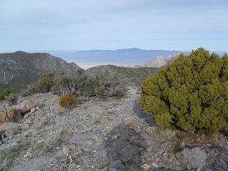
|
Bald Mountain (Area 51) from
Badger Mountain's main summit.
|
Halfway along this ridge is what I've called "Badger North" which has its own summit register
with the usual suspects. Hand-leveling suggests that Badger, farther south and the main goal,
might be one foot higher. Certainly visit both candidates.
We're all back to the cars around 10:20 a.m. - and with plenty of time for getting home the very same evening.
Andy and I caravan to pavement using the Madsger Pass route. Bob remains to climb Tikaboo -
a summit just west of our vehicles and well-known in UFO circles as a place for spying-into Area 51.
His account as extracted from an E-mail message is provided here because the hiking route features
truly bizarre objects and other oddities.
"From where we camped for Badger I walked tracks (ATV type) up about 150 vertical feet.
About a third of the way up I came upon a large fire pit (saw several on the hike to Tikaboo BM)
and an 8 foot cross made out of wood and painted mostly brown. The top of the cross was in the
shape of a man's head wearing a cowboy hat. The arms of the cross were the "man's" arms
outstretched. One arm had an index finger pointing north. The other arm had a clenched fist
holding an imitation air speed meter device. Near the leg of the cross was a much smaller white
cross and skull and bones (all out of wood, remember). There were little arrows pointing N, S, E, W.
On the back of the head was written "1923-2007 Lucille Perkowski". On the back of the arms
was written "191?-1993 John Perkowski Architect Black Projects". The "?" is not a mistype.
The lettering was not crude at all, letters elaborately cut into the wood and painted with gold paint.
There were other markings as well, including zodiac symbols and the word "PEACE". New Age?
Well, at the point where the "road" ended there was a trail leading all the way to the summit.
This trail was ridiculously over marked. There were a few cairns. Nothing remarkable there.
There were as well hundreds of rocks which had been marked with red spray paint. Way, way
too many. Sometimes there would be a reasonable space between them. But sometimes there
would be 10 or so rocks all spray painted within a few FEET of each other. Crazy.
Also there were many, way too many, caution ribbons of the type police use at accidents and
crime scenes. There was also brilliant red tape with stickum back side also tied or stuck to
bushes and tree limbs. But the most curious of all where the tin foil covered rocks, looked like
baked potatoes along and many times IN the trail. Lots of these and they were on all sections of
the trail. Also tin foil wrapped around bushes and tree limbs. Some fire pits filled with tin cans.
Empty water bottles along the way. Abandoned sleeping
bag near the saddle between Tikaboo and its sub-peak to the ESE.
The trail goes over the north end of the 2350 meter contour on the sub-peak and from the
terrain it more or less needs to. This means that one goes downhill after going over the edge
of the sub-peak before going up again to Tikaboo. While the elevation difference is 1000 feet,
I figured the elevation gain was about 1300. The antenna near the top is not for radio communication.
It is part of a Climate Monitoring Station. From the sign I read I gather it's not a weather station,
but a device used to research climate patterns. Saw the BM ok and signed a register left by someone
from LVMC (Las Vegas Mountaineering Club) 4-2011. There were a few other signers.
I arrive home around 7:15 p.m. with a huge earache caused by illness and the rapid pressure change
descending from the high desert by vehicle. In Riverside and San Bernardino the pain is so intense I have
to leave the freeway, park and take aspirin before continuing.
It is now Sunday April 1 - and I only now sense an improvement in the vertigo from a viral
infection creating abnormal pressure in my sinus cavities. Fortunately just one egg fell on the ground making supper
the other night - and just two exercise sessions will be missed for fear of falling-off the elliptical trainer.
Summary
We had a wonderful time with complete success (8 for 8 peaks) owing to good weather and even better planning.
I entertain another Nevada prominence trip for next Spring. Bob gets his desired 16 P300 summits
(this includes, of course, the 8 mountains of common interest).
My pickup truck's odometer read "147,508" on trip commencement;
and "148,899" on conclusion - a total of 1,391 "Adam truck miles"
which, as noted, suddenly appear to be roughly one thirty-fifth larger than normal, statute miles
(as the multiplicative inverse of 35/36, as one thirty-SIXTH less than 1.0, is one thirty-FIFTH more than 1.0).
However that shift took place about two-fifths distance through my journey with a slightly oversized spare tire.3
Prior to that shift my truck's odometer under-read by roughly one part in a hundred (1%).
The reader is encouraged to calculate my true mileage.
3. I have ordered a new tire of the desired size (P265/70R16)
and make (BF Goodrich Rugged Trail T/A) to be installed this coming week.
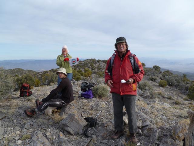
|
Badger Mountain main summit with Adam (seated),
Bob (red jacket) and Sarah (displaying State Highpointer's logo).
|