Pasquia Hills - Saskatchewan prominence point Trip Report
unnamed in Pasquia Hills (2,717+ feet)
Date: June 19, 2008
Author: Adam Helman
participants include Bob Packard and several pounds of mosquitoes
This effort was part of a larger journey
collecting state, national park, and Canadian provincial highpoints in June 2008.
The Pasquia Hills are located in east central Saskatchewan, with the nearest large city
being Prince Albert to the west. The nearest community of any size is Hudson Bay some
45 road miles south of our trailhead along Saskatchewan Route 9.
There is no trail or even useful approach road, the relevant Canadian topographic
chart from 1984 being outdated with its indication of a driveable road leading
west from Route 9 and extending to within 3 or 4 miles north of what is by far the
largest of eight 2,700+ foot contours.
Nevertheless the topographic chart is highly useful for cross-country navigation, and is identified
as chart "Otosquen" of the Hudson Bay Rural Municipality, scale 50,000:1.
By 2008 the former logging road has deteriorated to a marsh, with, humorously,
a beaver dam across its width approximately 7 miles in from Route 9 to the east.
Constrained to an overnight slog from Route 9, we have 17 hours of daylight
at and around the summer solstice, and 18 3/4 hours of useful light. That should suffice
to enable a dayhike of unusually long duration - saving us the burden of camping overnight
and hiking with full-sized backpacks.
Although there is water all-about, I do not trust it. I carry six quarts of water for the day,
and finish 4 3/4 quarts by day's end despite cool temperatures in the sixties.
The overall effort suggests bringing a lot of high-energy snack food.
Bob starts before me, having packed the previous evening, at 4:37 a.m. in full daylight.
Indeed we "waste" a full hour of light in not starting earlier - such are the statistics
of these parts in mid-June. I start at 4:55 a.m. and catch him roughly thirty-five minutes later.
Stopping for something important, the mosquitoes instantly congregate and envelop me
to the point of near panic. There are dozens, no - maybe one hundred critters either settled on
my clothing, hovering around my face, or otherwise annoying me utterly. What I need is DEET
insecticide - and I spray it liberally on all exposed skin. I smell like a chemical factory;
and don my mosquito net / hat combination for the day's balance.
After 3 road miles a washout precludes vehicular traffic, except possible an ATV.
After about 5 miles is a major junction; and I examine the map to be certain which track
to walk generally west southwest.
The road is now a grassy track, at times nothing but a marsh with faint signs of a former path.
The track fades away ever-more, and meets its ultimate demise at a beaver dam around mile 7!
We stop after 8 miles, perhaps one mile short of the former road's western end, because
further travel along it is perpendicular to the direction we must go to the highpoint contours:
the bushwhack begins. It has been 4 hours since I left the camper.
Our progress is disappointingly slow according to my GPS unit. After 1 1/2 hours we are only
about 0.8 mile from where the "road" was left. Bob expresses grave doubt about whether we can
get to the largest highpoint contour and return by dark - even though darkness is over 11 hours distant.
I say nothing and merely smile. Inside I know better - and yet am willing to push myself,
if need be, to meet our goal. I've never seen Bob so negative about making a summit.
Our times improve. We continue pushing south southwest on a rough heading of 220° true
(210° magnetic), then later roughly southwest. We cross the drainage of a large lake,
and enter by far the largest 2,700+ foot contour. Several hills within this contour are
investigated as we head generally south across its length until satisified that no higher ground
lies farther south.
We finally stop, no views. Just forest. We eat snack food amidst a horde of mosquitoes.
I am so disgusted with them that I hardly mind any longer as they land by the dozens
on my clothing. My peanut butter cream "whoopie" pie, bought weeks ago in Maine, is really a
round chocolate cake with peanut butter cream filling. 780 Calories - a meal by energy value
if not by nutritional content. Bob gets one-eighth of it, and we depart just
shy of 2 p.m. - having taken 5 hours of bushwhacking from the road.
At this rate we'll return to the road at 7 p.m., and be at the camper by 11 p.m. just after twilight.
We retrace our path using my stored GPS waypoints. Whenever within 0.1 mile of the selected
waypoint I switch to the next waypoint so as to lower the total distance by "cutting corners".
Three hours later, and 0.95 mile from the "road", Bob discovers a worn track - and we take it
rather than bushwhack since it heads generally north in our desired direction.
The track, muddy at times, is vastly better than bushwhacking over deadfall and through brush.
Using it, we return to the "road" at a quarter of 6. I "celebrate" our "deliverance"
with a pecan pie tartlette; and walk just shy of 6 p.m.
My upper right thigh hurts me from the overall level of effort, and, fortunately the pain largely
vanishes for the final 2 miles as endorphins kick-in. Once I must stop to urinate and five
mosquitoes alight on the relevant anatomy when bared to the daylight. It's disgusting -
but at least here (and in contrast to our southeast Asia climbs last summer), malaria is not a threat.
I return to the camper at 9:25 p.m. exactly 16 1/2 hours after departing. Bob arrives about
ten minutes later - for him, a 16.8 hour day. After 26 miles we are both sore and tired.
I estimate that today, with some 15 hours of actual movement, I burn more calories
than on any previous dayhike - 2,400 - with the possible exception of dayhiking Mount Whitney.
We enjoy a large pot of Hamburger Helper macaroni and cheese,
to which we add a good amount of salami grilled stovetop. It is the only camper-bound meal of the entire journey
that we share, all other times enjoying our own food (yet often sharing small portions nonetheless).
This is easily the most thankless dayhike of my experience when you consider the combination
of no views, no visible confirmation of when we had succeeded, difficult navigation,
great duration - and mosquitoes. That written, I claim it
would be hard to find others who have been to the Saskatchewan prominent point.
|
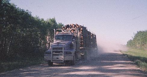
A logging truck barrels north on Saskatchewan 9, creating a large
dust cloud in its wake and seemingly unmindful of other vehicles.
Strangely, empty trucks were southbound.
What is under construction in the far north?
|
Key GPS-derived waypoints follow (zone 13) using the NAD27 Canada datum,
selected as that employed in the 50,000:1 Canadian topographic chart.
The variation in altitude observed within the largest contour is far greater than the
variation possible in the remaining seven contours. Hence we are confident
that the highest ground was visited at some point in our bushwhack,
and is one of the five waypoints identified below as "hill within largest contour".
| waypoint description |
elevation (feet) |
(Easting, Northing) |
| trailhead at Route 9 |
1,219 |
(693941 E, 5926768 N) |
junction on logging road prior to
becoming a marsh (5 miles "in") |
2,187 |
(687037 E, 5929230 N) |
depart "road" and
begin bushwhack SSW |
2,572 |
(681685 E, 5926455 N) |
| hill within largest contour |
2,8941 |
(679391 E, 5922197 N) |
| hill within largest contour |
2,8091 |
(679299 E, 5921911 N) |
| hill within largest contour |
2,8811 |
(679102 E, 5921845 N) |
| hill within largest contour |
2,6851 |
(679133 E, 5921527 N) |
| hill within largest contour |
2,7661 |
(679026 E, 5921300 N) |
1 inaccurate elevation to due insufficient number of signals