Hot Springs County Highpoint Trip Report

Washakie Needles (12,518 feet)

Dates: August 7-8, 2007
Author: Adam Helman

participants: Charlie Winger, George Vandersluis, Tim Worth, Adam Helman

Note 1: All coordinates are NAD27. Topographic charts are not too useful
              high up owing to the convoluted terrain and hence a seeming jumble of contour lines.

Note 2: Click on any photograph for enlargement. Full descriptions are given in the
              Hot Springs County photo page.

Note 3: All photographs are courtesy of Charlie Winger.

Note 4: I have added comments by Charlie, George, and John Mitchler where appropriate.

Overview

Washakie Needles is deserving of the county highpointer's APEX status. Since the first ascent in 1950, it has been scaled only about thirty times.

Most hiking approaches have been from the west. In this note an eastern approach is described, one greatly shortened through acquisition of a key from the Robbins - ranchers who own much land along the access road (307-867-2374).

One plans for a two-day backpack, the first day for establishing a high camp; and the second day for summitting and return to the trailhead.

The climb would be doable in a single day from a camp at Rock Creek where we left our vehicles; as we took less than two hours to reach our backcountry camp, and just one hour to descend. As we returned by 4 p.m. this itinerary is feasible with favorable weather, implying a 7 p.m. return before sundown.

Washakie Needles
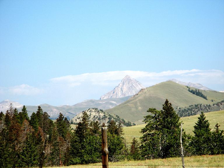
Washakie Needles viewed from
the BLM1310 approach road.
Technical climbing consists of two summit pitches. Of these, the second pitch entails a knife-edge ridge with sobering exposure. The first pitch is sufficiently steep for a rappel. These sections are preceeded by 600 vertical feet of scrambling on very loose rock and scree; and, indeed, as one is unroped for this portion, it may form the greatest objective hazard.

There are no major navigational issues for this peak. Obstacles include key acquisition, dry weather (to ensure a passible road), and the aforementioned scree slope and summit pitches. In late summer one might plan for a dry high camp by collecting water from Rock Creek.

This effort was part of a larger journey collecting county highpoints in late July and early August 2007.

Approach Drive

Thermopolis, Wyoming is a convenient overnight stop and rendevous location for meeting participants. Reasonable rates are available at the Coachman Inn 1.0 mile south of city center along Highway 20. They serve a free continental breakfast (307-864-3141 and 888-864-3854).

From city center it is 59 road miles to the "trailhead" along Rock Creek. Thus begin the approach drive with at least one-half tank of gasoline per vehicle.

From the traffic light at the center of Thermopolis, head west on Broadway which is WY 120. Proceed west and northwest for approximately 8.5 miles. Turn left onto WY 170 and proceed 9.4 miles where you should continue straight onto WY 174 which becomes County Road 1 (unsigned Owl Creek Road) after another 0.5 mile. It is approximately 8.0 miles more to the Robbins House. From there, continue west and go straight when the pavement ends. Zero your odometer and bear left left (south) toward Anchor Reservoir (signed as 5 kilometers). At 1.5 miles re-zero the odometer and turn right (west) onto road BLM1310 where a sign indicates 15 miles to Rock Creek (an underestimate).

climbing route
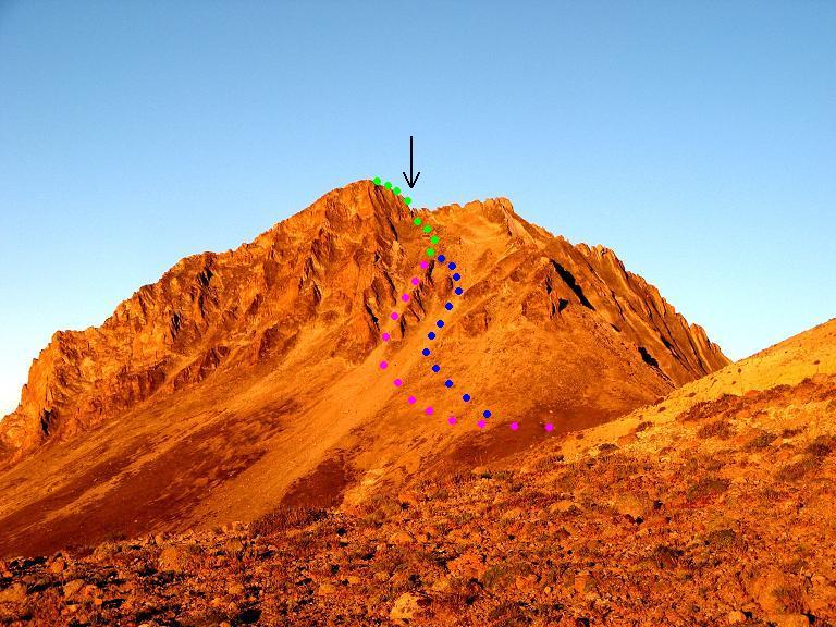
The climbing route outlined on an
early morning view from near P12072.
Two possible routes through the talus
slope are shown in blue and violet.
A black arrow marks the skyline notch.
(Mouse-click for an enhanced view.)
BLM1310 is taken clear to the trailhead along Rock Creek. It gradually deteriorates, and, unfortunately, at 22.3 miles one-way, makes for a long and uncomfortable ride. We consume 2 hours 15 minutes from Thermopolis to Rock Creek - and all but 30 minutes is along BLM1310.

After 12.4 miles along BLM1310 a locked gate is encountered. Hopefully one has acquired a key from the Robbins family. Otherwise one has an additional 22.3 - 12.4 = 9.9 miles of walking each way. This distance would make the climb a three day affair with each day being nearly "full". Not acquiring the key (and permission) would be trespassing and should be discouraged, as the Robbins' might discontinue future access.

At 18.5 or 18.9 miles encounter a junction. Bear left (west), descend and then cross the streambed. Continue under ever-deteriorating conditions, driving as far northwest, paralleling Rock Creek, as your nerves and your vehicle tolerate.

We park our three vehicles here after 22.3 miles of travel along BLM1310: GPS-derived UTM (649399 E, 4844062 N) at 9,390 feet. There is a USFS gate there which prohibits vehicular entry. Regardless, one cannot drive much farther as the road ends anyway. At our trailhead a sign indicates that the area is closed to vehicular traffic because of "Riparian Rehabilitation".

climbing route
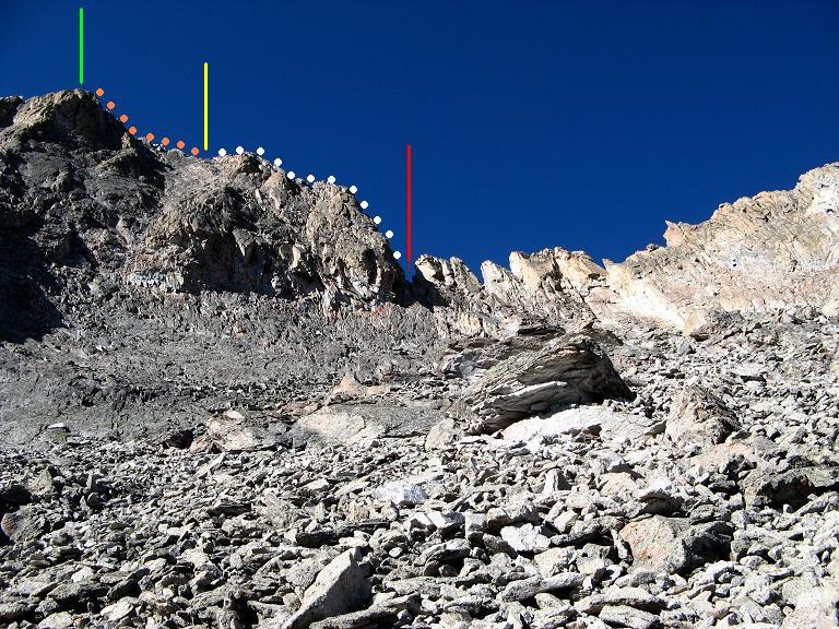
The upper mountain with various features noted -
* Red line for the skyline notch;
* Yellow line denotes the second pitch;
* Green line for the summit.
(Mouse-click for an enhanced view.)
This road must be driven when dry, for otherwise ruts, potholes, and stream crossings fill with water and then turn to mud. Conceivably this could occur while climbing - and then your are stuck in the backcountry without a means of egress until the road dries. I recommend at least five days of nonperishable food to hedge your bet. Water will always be available from Rock Creek.

Approach Hike to Camp

There is a trail, not obvious from the Rock Creek streambed, that takes you north, then west a bit, and finally south (at about 10,200 feet) to a flat area we used as high camp. The trail begins here, leaving Rock Creek and proceeding as described. Missing this trail means going too far up the Rock Creek streambed, as it curves west, and then bushwacking steep slope south to the forest so as to exit the gully.

Upon reaching this trail junction head south and establish a camp at roughly (648071 E, 4845177 N), elevation 10,090 feet. Here, water might be available in the stream immediately south as it flows eastward. In the late summer you should anticipate a dry camp by taking a gallon from Rock Creek for each climber. As the approach hike to camp lasts only ninety minutes, the additional weight is not too burdensome.

skyline notch
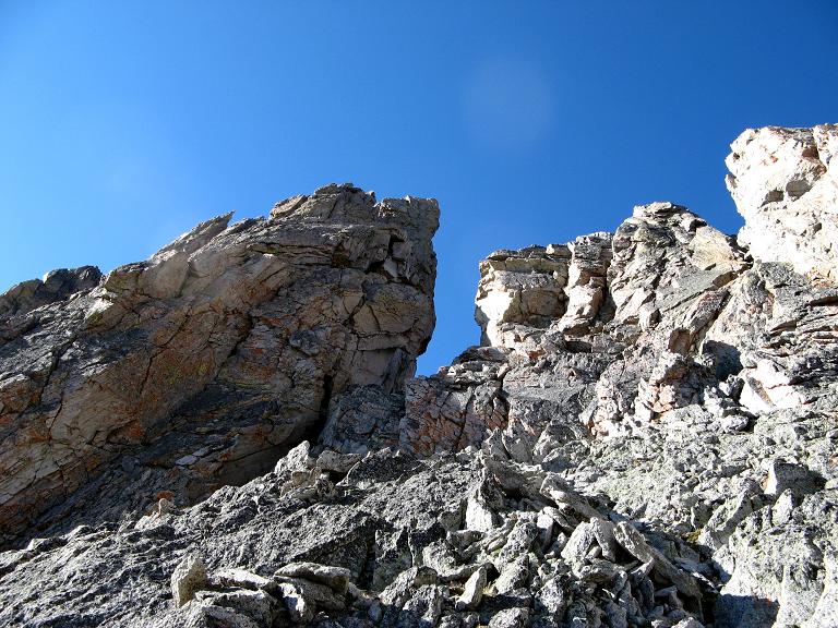
Closeup view of the skyline notch.
The first pitch ascends the steep face
to its left; and proceeds over the left skyline.
With a dry camp one has the option of sleeping higher by hiking west up the drainage, possibly establishing camp just shy of this 11,140+ foot north-south trending ridge.

We find water in the creek, and enjoy a lazy afternoon in anticipation of summit day.

Summit Day - Approach Hike

Arise early to mitigate the afternoon thunderstorm threat. My alarm sounds at 4 a.m., and after hot oatmeal we are hiking west by headlamp at 4:48 a.m. There is a nice trail which one can follow to the ridge. On the aforementioned ridge it is very windy, and, as the sun has yet to appear, I have to wear all of my layers, and move briskly, to remain warm.

Heading north, hike counterclockwise over, or sidehill around peaks 11,500, 11,429, and 12,072 feet. You can sidehill to the east of the first two hills to avoid windy conditions on the exact ridgeline. However, owing to unwelcoming terrain you must go directly over peak 12,072 prior to descending south towards the 11,800 foot saddle immediately north of Washakie Needles.

second pitch
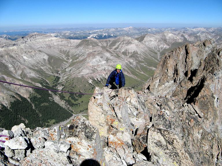
Adam Helman on the second pitch
with a modest degree of exposure.
We reach this saddle, still under very windy (but warming) conditions, just after 7 a.m. - some 2 1/4 hours after leaving camp.

Summit Day - Climb

Contour to the base of the northeast face of Washakie Needles. Your immediate goal is the obvious skyline notch, one that lies within 100 vertical feet of the summit to its left (east). Eat a high-energy snack, possibly don helmets (we did - this is very loose rock), and find some path of least resistance to the notch's base. Travel in staggered formation, with no climber directly in the fall-line of another, is recommended.

We reach the notch at 8:10 a.m. It is now much warmer, yet wind remains problematic once on the summit ridge.

A 150 foot rope length is sufficient for a two-pitch climb. Charlie W. free-climbs the first pitch, belayed by long-time companion George V. It is wonderfully obvious they "have their act together", with complete control of the rock. The belay should be stationed above the 5-10 foot tall chockstone which sits at the notch's base.

The first 20 or 30 feet is nearly vertical, and yet, for my sake, is rated Class 4 even though some might call it low Class 5. Charlie places one piece of protection for this pitch. He rates the climb 4th Class overall, and could be done without any protection/rope if one is accustomed to exposure and rock climbing.

on rappel
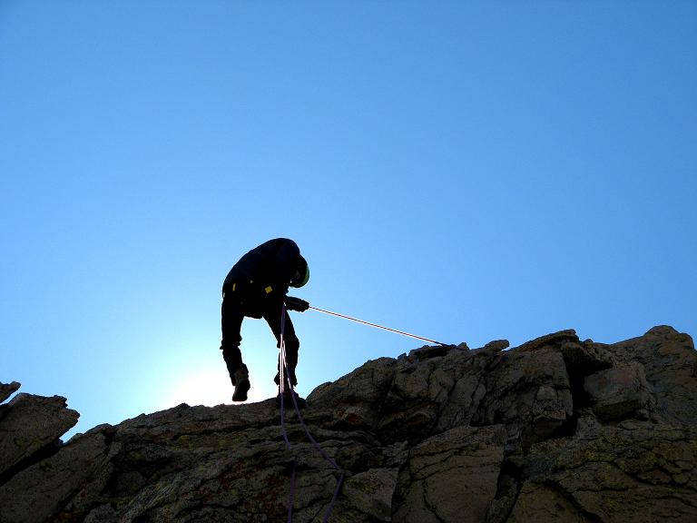
Adam rappels the first pitch
while backlit by the morning sun.
Charlie notes the protection he used was only necessary if you have a rope and someone following - so they don't go over the edge if they fall. He used a small stopper/chock about 3/4" in size (a Camalot of size .75 would also have worked) on the first pitch; and only a sling around a rock feature for the second pitch (placed for the same reason as the first piece of protection).

There was an existing anchor and carabiner (now ours) at the end of the first pitch. An anchor can be used for belaying/rappelling back to the notch if a rope is used. We have no problem pulling the rope after everyone descends.

First I and then Tim climb the pitch, tied into the rope with a prussik loop. George is last, and we all crowd together in an extraordinarily small and exposed location at rope's end. It is windy - and I need Charlie's coat, as a fourth layer, to stop shivering. Some more food probably helps too - stuffed in my windlayer's right pocket now that my pack sits below the chockstone. A figure 8 rappel device lies in the left pocket, while an assortment of carabiners dangles from my harness.

The second pitch begins at a modest angle, and quickly becomes nearly horizontal - yet with great exposure: perhaps 400 feet to the left (north) and 1,000 feet to the right (south). The ridge is knife-edge here with only one or two rocks defining it at any location: a mere 1 to 2 feet in width - NO MORE!

Somehow Charlie's walkie talkie dies, and we shout commands over the wind. I climb after him, and, holding the rope even after coming off-belay, tag the very summit with its distorted metallic benchmark.

Tim and then George follow, and soon all have stood atop the highest point.

It is 9:30 a.m. - and Washakie Needles is ours.

I emphasize that the exposure is humbling on the second pitch. However at that point the route is horizontal, and is (only) Class 3 or 4. With a 150 foot rope it is possible to rappel the first pitch (which IS steep), from the intermediate belay point used to establish the second pitch.

Extra gear and waiting bodies can sit below the notch chockstone. Whereas the recommended belay point lies atop the stone, on rappel, aim for below the chockstone as there is plenty of room there for a solid landing.

On a previous climb the party did not rappel off - rather they downclimbed the same route with rope in place. The following paragraph by John Mitchler of that earlier climb provides additional details of the technical portion.

"Once on the chockstone, you climb up about 10 feet, and your route is basically up and around to your left. You are immediately faced with the crux move (in my opinion) - a belly-roll up and onto a downward slab. After that, it is an exposed scramble/climb around to the left and up onto the rock fins along the spine. There is one interesting move, especially coming down, that requires you to swing out and around a block and down, basically blind. The leader can weave the rope around the rock fins for friction."

I emphasize that perhaps the greatest subjective hazard of this route is the roughly 600 vertical feet of 45-degree, very loose, broken rock and talus. John Mitchler agrees. Once you get to the "skyline notch" (visible from the 11,800 foot saddle), your effort evolves (and for the better, I feel) from annoying scree to a thrilling, two-pitch "technical knockout" on solid rock.

Bears inhabit the area. During that earlier ascent, and while several were on the upper route, Mike Coltrin sat on the barren saddle (between the approach ridge and peak) with John's camera taking photographs. The party watched in horror as a sow and cub came up from the left, but turned around just short of meeting Mike.

rock slab
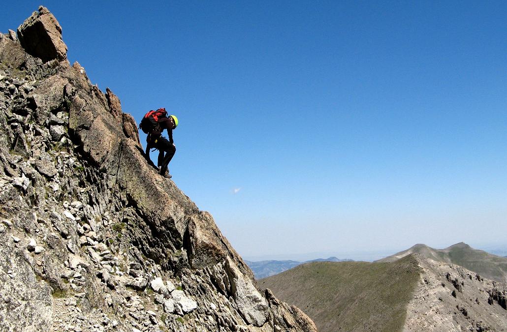
Adam descends a steep rock slab
to avoid nasty talus and scree.
We descend the ascent route, electing a rappel for the final pitch to the skyline notch. A ten minute break, with food, water, and gear organization, is enjoyed prior to an exceedingly cautious descent of the talus slope. It is about 11 a.m., and, by noon, we are "safely" back at the interconnecting, 11,800 foot saddle.

I arrive campside just after 2 p.m., and we are "off", downhill, at 2:53 p.m. The descent consumes just over an hour, arriving at our vehicles roughly "four-ish".

We drive at 4:15 p.m. and, true to our estimates, return to Thermopolis 2 hours 15 minutes later at 6:30 p.m.

Après Climb Festivities

I treat Charlie and George to dinner - my acknowledgement for their expertise on the rock when it really mattered. The trout almondine is succulent. The fresh salad with blue cheese dressing and hot, soft, buttered bread is a darned sight better than trail food! After the baked potato I call it quits, bid farewell to the crew, and head to the backlot of an abandoned supermarket for my slumber.

Tim Worth drives home to Colorado that evening. Rather than leaving him in-the-cold insofar as dinner, I stay at his place the next evening, and, because it seemed to be of mutual interest, treat him to a most sumptuous (and expensive) dinner at the local Italian restaurant. Although but one block away, Tim had never been there!

Tim starts with a Ceasar salad - accompanied by a dish of anchovies just as per the classic recipe. I have a Greek salad with feta cheese, calamata olives, red peppers, topped with fried onions, and served with balsamic vinaigrette. A glass of Valpolicella wine accompanies this first course.

We proceed to share down-the-middle a pair of entrées - cannelloni peppino (stuffed with spinach and ricotta, then baked with mozzarella and Alfredo sauce) and veal parmagiana (served with perfectly cooked beets and roasted potatoes). Extra garlic (my request) enhance both dishes, while a glass of sangria (before the main course) is appealingly sweet.

For dessert I have a vodka and Godiva white chocolate liqueur martini in a chilled glass - accompanied by a Little Debbie's chocolate cupcake I sneak into the establishment.

Total charge with tax and tip: seventy eight dollars...YIKES!

I drink rarely, and I cannot remember when I've spent so much on one meal. However I consciously released myself from self-imposed restrictions in the interest of a one-time celebration. Is that not part of enjoying Life?

We walk the block to Tim's apartment, and I promply fall asleep for an hour. On awakening we send an elaborate E-mail message to Edward Earl, providing tips and suggestions for his upcoming joint climbs of Mount Hilgard and Washakie Needles with Greg Slayden.

That weekend I complete the Colorado county highpoints with ascents of Mount Lincoln and Vermilion Peak. That said, climbing Washakie Needles competes for the title of "Most memorable experience" in my three week journey.