Sheridan County Highpoint Trip Report

"Split Rock" (11,020 feet)

Date: August 4, 2007
Author: Adam Helman

new trailhead and route

Note 1: all coordinates employ the NAD27 datum.

Note 2: Click on any photograph for enlargement. Full descriptions are given in the
              Sheridan County photo page.

This effort was part of a larger journey collecting county highpoints in late July and early August 2007.

The Coney Lake trailhead has moved roughly two miles west along FH26 to GPS-derived UTM zone 13 (315662 E, 4942570 N) at 8,891 feet. This point is 16.0 road miles via a western approach from highway 14. In turn, the Highway 14 / FR26 junction is 44 road miles from Greybull, Wyoming in the Big Horn basin.

I slept in my camper shell at the trailhead lot, there being no sign indicating "no overnight camping".

The next morning, and at a brisk pace, it was 1.5 hours from that trailhead, first south and then west, to the southeast edge of Coney Lake at UTM (313499 E, 4939544 N) at 9,278 feet.

Sheridan cohp
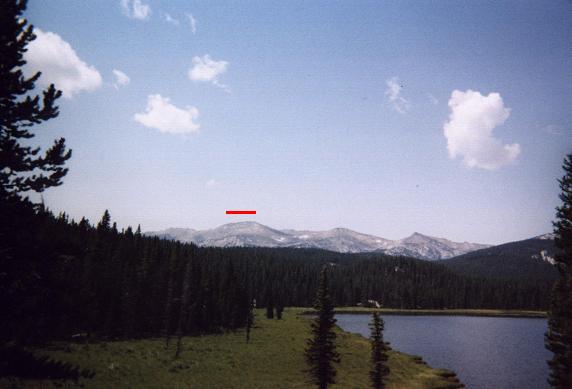
The Sheridan County highpoint lies
under the red horizontal line.
Previous reports describe heading west to the summit ridge, thence south along its length. Instead, I embarked southwest directly for the highpoint area. After skirting the south edge of Coney Lake, one crosses a damp meadow, heading west, and then reenters the forest at a shallow boulder field. Avoiding the cliff formations to the north and south, negotiate the boulders and then assume a southwest heading, possibly with aid of some faint path leading in that general direction.

An advantage of this route is the absence of any elevation loss clear to the highpoint area. This contrasts with any route passing over the north-south main ridge.

The alpine forest gives way to tundra above 10,000 feet, and makes for a clear view of your goal. A footpath was available for all but the final 500 vertical feet. For that section, grass and rock are negotiated at a modest incline until perhaps the final 150 vertical feet. Then, climb over boulders and some slabs to the base of the summit block - the overhanging boulder dubbed "Split Rock" by some.

A second advantage of this route is that one bypasses the downclimbing required in a ridge route, coming from the north of the summit boulder, in order to reach its base.

Split Rock environs
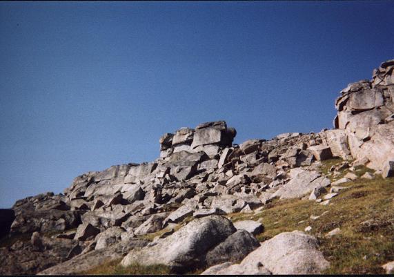
Split Rock from the northeast
and a few hundred feet below.
A Class 3 ramp (ten feet) leads steeply to the south side of Split Rock near its base. I deposited my pack at this point, and considered how to access the rock's base: it was not at all obvious how to get there. Finally I muscled my way up a slight weakening on the west side, and found myself at the north entrance to the rock's well-known internal cavity. Later I found an easier means of descent on the south side of the rock's base.

After a foothold some eighteen inches up, I was left without options apart from jamming my back on the eastern wall while using upper body strength to shimmy-up the remaining verticality - until I was kneeling atop the lower, south/west half-boulder. I gingerly stepped to the higher, north/east half-boulder, and sat briefly on its highest point.

Descent was a controlled "fall" through the cavity.

I retrieved the daypack and descended some 200 feet before enjoying my summit snack food.

The round-trip consumed 7 1/2 hours on account of a painful lower back. Indeed, I had not enjoyed the overall experience because every other step hurt as the pressure of ground contact was transmitted to my spine. Upon returning to Coney Lake I took a Motrin pill and lay down on a big boulder with my back hyperextended to straighten it and thereby lower the pain.

Split Rock closeup
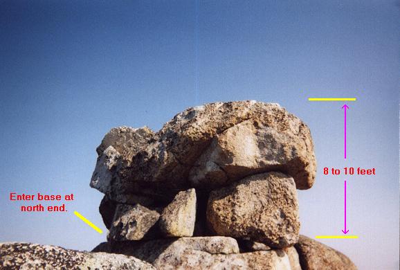
The Sheridan County highpoint's south aspect.
Access to the internal cavity
providing summit access is from the
north end of this overhanging boulder.
It may have been dangerous, or even foolhardy, to travel alone under these conditions: what would happen were I unable to walk at all? I would then have to crawl back to Coney Lake - whence some hiker or horseback rider would soon be available to assist me.

On a "normal" day I should have taken 6 hours.

The net elevation gain is 2,100 feet. I estimate 350 feet of downhill travel from the trailhead to Coney Lake. Hence the total elevation gain for the described route is some 2,800 feet.

The next day, in Worland, I enjoyed a pint of Starbuck's coffee fudge brownie ice cream to celebrate my efforts.