Montezuma County Highpoint Trip Report

Lavender Peak via Tomahawk Basin and other approaches

Date: August 30, 2004
Author: Adam Helman

Note 1: All NAD27 UTM coordinates are in zone 12S.
Note 2: Click on any photograph for enlargement. Full descriptions are given in the
              Montezuma County photo page.

For decades Hesperus Mountain was believed to be the highpoint of Montezuma County. Recent evidence has cast that into doubt - with nearby Lavender Peak possibly being higher by a mere eight feet. The various arguments in favor of each peak are provided in this web page.

Armed with just this information, Edward Earl and I decided that Lavender Peak had the greater chance of being the county highpoint. Prior to departing San Diego, California, John Mitchler advised us that he would attempt to climb Lavender Peak on Saturday, two days earlier than our effort, with a hand level to make exacting comparison of relative heights. John said to call him on Sunday to share his findings with us. We attempted to call John upon passing through three towns enroute to our campsite, and each time I was prompted (taunted?) by a voice mailbox to leave my message.

We never contacted John until well after our attempt - an attempt that failed owing to insufficient route information.

I describe both our aborted attempt (c.f. "The Bad" below), as well as the route taken by Andy Martin for a successful ascent via the same Tomahawk Basin approach (c.f. "The Good").

Route descriptions for other summit attempts are described, including a route up the east ridge of Mount Moss by John Mitchler; and a route from Centennial Peak by Dave Covill and Jobe Wymore .

This climb was part of a larger trip described in detail on my personal web pages.

Approach

Tomahawk Basin is accessed from the south. From Durango, drive west on route 160 about a dozen miles to road 124, the 160/124 junction located less than a mile west of the junction of route 160 with route 140.

Alternatively, from Cortez, drive east through Mancos and continue perhaps fifteen or twenty road additional miles to the same 160/124 junction. Edward and I drove this way, having come from Beautiful Mountain, the San Juan County, New Mexico highpoint.

Route 124 is paved for perhaps four miles, and passes through a couple of somewhat small communities. Several pay-for-use campgrounds are located farther along as the now dirt road continues to gain elevation.

The highest campground prior to Tomahawk Basin is located at about 9,800 feet within one-half road mile of a junction with the jeep road that runs up the desired basin - a road that requires either four wheel drive or a lot of nerve to not simply walk. Edward and I camped there, without paying a use fee since facilities were minimal.

It is about ten road miles along route 124 from its origin along route 160 to the jeep road junction - one that forms a severe angle of about 150° with the main road. The junction coordinates are (761676 E, 4145901 N) at 9,900 feet.

The jeep road soon turns west up the basin, passing the abandoned Tomahawk Mine partway up its course. A use trail at one switchback saves much travel distance by going directly to the road at a higher level. The switchback has a fire pit immediately south and is a good place to have a short break.

Lavender Peak
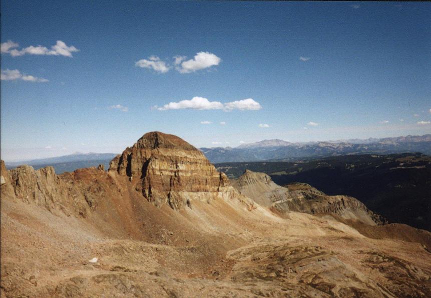
Lavender Peak from the 12,900 foot
saddle just east of Mount Moss.
The road continues to switchback up the south-facing slope immediately to one's northeast, taking you away from a direct route up the basin. One can, however, profitably take the road up to the abandoned Little Kate Mine at roughly 10,800 feet. After leaving the road, locate a hiker's path that continues west, paralleling a metal water conduit for a short time; passing a waterfall (when in-season), and eventually gaining the basin's head at roughly 12,000 feet.

The Bad

Here is where our storehouse of information ran dry. Edward and I debated whether to climb a steep scree slope immediately north to a 12,900 foot saddle just east of Mount Moss, or to continue west to the ridge trending southwest from Mount Moss. In either case a traverse would follow, and possibly a ridge walk, to gain the summit of Lavender Peak.

Somehow I convinced Edward to go up the scree slope - a decision fatal to our summit bid and to our completion maps which now "go red" as a result.

Centennial Peak
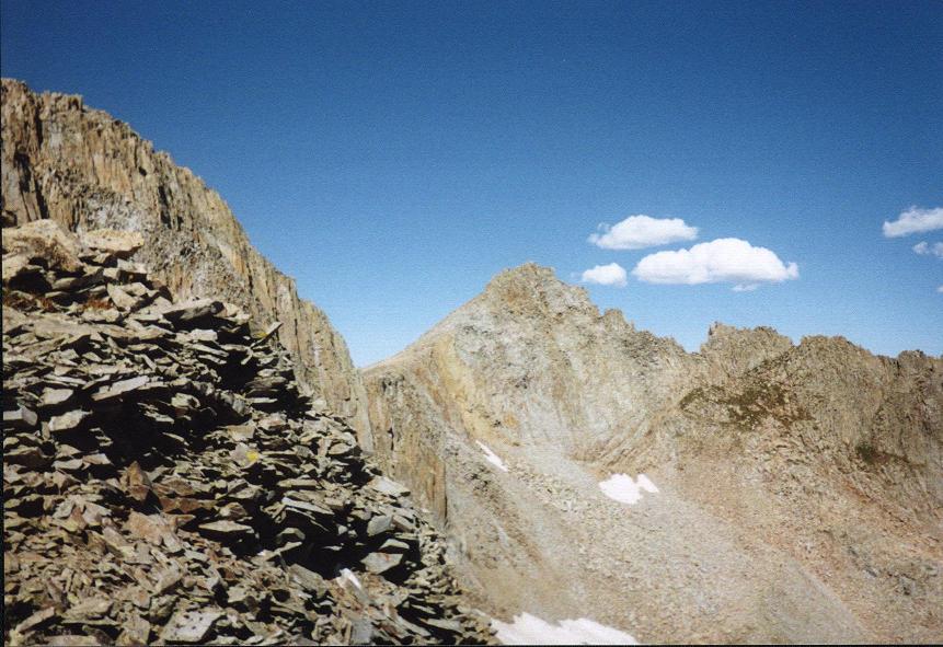
Centennial Peak from the 12,900 foot
saddle just east of Mount Moss.
At photo left is the sharp, pinnacled
Lavender Peak / Centennial Peak ridge.
The Ugly

The scree was quite annoying and dangerous to climb, particularly the upper one-half after passing to the left (west) of a twenty foot tall rock formation that I dubbed a "mini Ship Rock". Upon reaching the saddle we were greeted by class 5 terrain leading to Mount Moss; and steep, nasty talus and scree leading down into the adjacent basin on our north, terrain that could theoretically be used to access the Mount Moss / Lavender Peak saddle without having to climb over Mount Moss itself. Even this route would not pass muster in Dave Covill and John Mitchler's excellent guidebook to the Colorado county highpoints. We also noted that the Lavender Peak / Centennial Peak ridge is sharp and heavily pinnacled.

We took some photographs to document the view, so providing evidence that our route is definitely not the way to climb Lavender Peak. Our saddle is located at the center of this map at UTM (758814 E, 4147377 N).

Tomahawk Basin
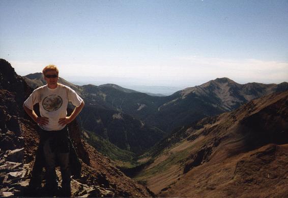
Tomahawk Basin from the high saddle
just east of Mount Moss.
Edward poses in the foreground.
Edward had a large oatmeal raisin cookie. I had one of those small, fried fruit pies shaped like a pasty that you find three for a dollar when on-sale, naturally with milk. Cherry was today's flavor - enhanced with some cherry/chocolate chunk macaroons for additional "inherent flavor interest" (remember this is Adam we are talking about :-).

The descent was at least as outrageous as the ascent, and I did not find any enjoyment in the effort until back on solid ground at the 12,000 foot level - amidst grasses and a stream beginning life as a mere trickle fed by last winter's most persistent snowfields.

The Good

The correct route for Lavender Peak via Tomahawk Basin was recently described by Andy Martin. Rather than heading north as we did from the basin's head, Andy continued west to breach the cliff bands of the southwest ridge of Mount Moss about one thousand (horizontal) feet from the summit - and as shown on this map centered on the ridge at UTM (758441 E, 4146930 N).

scree slope
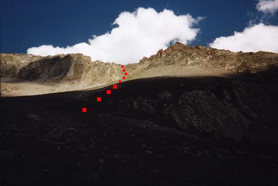
The 900 foot scree slope appears
in sunlight, leading to a saddle
just east of Mount Moss (at photo left).

Our route leading to nowhere is
indicated by the receding red squares.
The following is a description of Andy's route as summarized by Dave Covill in private correspondence -

"He went several hundred yards S of Moss, along the saddle, and had no problem gaining the saddle, and swinging around to the SW side of Moss at that elevation. He stayed below the saddle, and traversed under the Lavender face, and made some Class 3 moves to gain the summit.

He said that there were 3 small pinnacles, the westernmost being higher by a foot. He hand-leveled W to Hesperus by standing next to the summit block, head even with it, and leaning against it, instead of trying to lay on top of it and dangle over on all sides."

Edward and I had an uneventful descent to his pickup truck, one that he had parked on road 124 perhaps two hundred (horizontal) yards shy of the critical jeep road junction due to questionable road conditions. The elapsed time was some seven hours, including a 30+ minute "summit" break as well as all others.

Mount Moss East Ridge (John Mitchler)

The following is an excerpt from an E-mail message by Dave Covill in private correspondence.

"John Mitchler of Golden CO (50-state completer), and his fianceé Kathy Dalsaso attempted the same basin a week later,1 and tried to gain the E ridge of Moss. They made good progress, but reached a cliff-out notch a few hundred feet below, and a few hundred yards E of Moss' summit, and had to turn back."

Centennial Peak - Lavender Peak Ridge (Dave Covill and Jobe Wymore)

The following is an excerpt from the same E-mail message by Dave Covill. I have made minor grammatical changes for readability's sake.

"Jobe and I did not know the particulars of the Martin expeditions. We left Sharkstooth Pass at 11,950 ft, and ascended the easy north ridge of Centennial Peak to about 12,400 ft, then left it and found a bench on the northeast side to take us all the way around and into the northeast basin bounded by Moss, Lavender and Hesperus.

We encountered 4 to 5 inches of snow from this point forward. There had been 1 to 2 inches at the trailhead. This basin is composed entirely of small to medium talus, and we found it to be very hazardous going, carefully watching our step to avoid a broken leg. We got up into the basin past the massive east cliffs of Centennial Peak, and could not see an obvious route up. There are steep, narrow couloirs, and steep rock, all around.

We finally chose the least of all evils, and made for the ridge between Lavender and Centennial Peaks, aiming for a point about 500 ft horizontally from the crest of Lavender Peak. We finally gained this spot, and looked over to see the 1,000 ft drop to the basin below to the northwest. We climbed higher, well above the Mount Moss saddle, and reached a point where the large desk-fridge sized boulder let us down. There were no more foot or handholds, the rock was steeply angled, and it was covered with slippery snow. To have gone forward and slipped would have been certain death down a 60 to 80° slope hundreds of feet down into the talus basin. It was too scary to proceed up the crest of the ridge itself. We agreed to turn back, and attempt it in better conditions, possibly from a different approach route. We felt we we topped out at about 13,050 ft, some 150 ft shy of the top, which was clearly in view above us.

We made our way back over the nasty talus to the Centennial Peak north ridge, and Jobe, being young, studly, and energetic, announced he would not go back without some sort of success. I was too pooped, and agreed to wait for him there. He ascended in about 15 minutes to the top (700 ft up), and disappeared from view for a few minutes.

Turns out Jobe had the presence of mind to whip out his 2X level, and he looked at an equal-elevation spot on Lavender Peak, then did the same to Hesperus Mountain. Jobe felt that Hesperus Mountain had noticeably more "mountain" above the level spot than did Lavender Peak. He then looked at the summit of Lavender Peak, and the bubble was still visible entirely at the top of his tube. Jobe then looked at the top of Hesperus Mountain, and the bubble almost completely disappeared from his sight. He concluded that Hesperus must be higher, although whether that was 5 ft or 25 ft, he didn't know. It is important to note that Lavender Peak is about 0.5 mile from Centennial Peak, and Hesperus Mountain is about 0.7 mile from Centennial Peak.

Our expedition was a failure in the sense of gaining the summit of Lavender Peak, although we did manage to garner one more small piece in the jigsaw puzzle. When a highpointer sites back and forth across a half mile or so to an equally high peak, each one seems higher than the one you are looking from. Furthermore, when levelling from a spot 5 ft or so lower than another spot, they seem about the same elevation, and yet when you go over and back-site, the higher spot seems 8-10 ft higher using a normal hand level.

Given the above general observations regarding siting and back-siting, I conclude that there is an 80+% chance that Hesperus Mountain is higher than Lavender Peak. For Lavender Peak to be higher would necessitate that the USGS topographic quadrangle be missing two forty foot contours. In contrast, the summit of Lavender Peak, while somewhat pinnacled, is in general rather rounded, with little or no potential for a 20 to 60 foot pinnacle to have been missed by the survey team.

The proper way to resolve this is for someone to go with a 5X level (me), or better (Richard Carey, Ken Oeser, etc...). Another good thing to do would be for someone to go to both peaks, levelling in both directions, with the same hand level, so as to eliminate as much error as is possible. Unfortunately this exercise may have to wait for next year. My feeling is that until such a "survey" is done, Hesperus Mountain should be regarded as most likely being higher than Lavender Peak. COHPers should go to Hesperus Mountain first, and if they have time, visit Lavender Peak as well.

This is a beautiful area, one of Jobe's favorites. Hesperus Mountain, cloaked in a mantle of white, proudly demonstrating its banded nature like a US flag, is an impressive sight. To visit the six thirteeners in the area would be a neat Tour-de-La Plata."

                Dave (worn out from the weekend, but reporting to you with my level best...) Covill

Summary

As of mid-September 2004, the time of this report, the "Hesperus / Lavender question" remains unsolved. I am prepared for a return visit after the true highpoint of Montezuma County is learned, particularly as Montezuma County constrains both my home glob radius (542 miles) and my floating glob radius (320 miles).

I beseech the Colorado climbing community to make a final determination, along with a reasonably safe and sane route should Lavender Peak prove the winner. A completely adequate route up Hesperus Mountain is provided in Dave Covill and John Mitchler's guidebook.

Edward Earl and I continued our road journey, the Colorado portion of which culminated atop both Mount Wilson and Wilson Peak but a few days later.

1 John's attempt was on Saturday, August 28, 2004.