Colorado and Utah end August early September 2004 Trip Report
© September 2004 Adam Helman
(Click on any image for enlargement.)

Background

To a county highpointer, especially in the western United States, a state completion is the holy grail. Having but two counties remaining in Utah, the primary goal of this journey was quite plain.

However it was uneconomical to travel from San Diego just for two counties. As I was (and still am) dreaming of a Colorado state completion some year, several counties in southwestern Colorado were also scheduled for this trip, at least as it was initially configured.

Along comes an elk in northeast Oregon, smashing the front end of my Tacoma truck and threatening to force cancellation of the entire affair as the once beautiful vehicle sat endlessly in the body shop.

Edward Earl came to the rescue. He too wanted several county highpoints in the rugged San Juan Range of Colorado's southwest, principally for their prominence, as well as for their inherent difficulty relative to other Centennial State county highpoints.

I formulated an alternative travel itinerary which, although being constrained by Edward's work schedule, nevertheless allowed me to secure the most important of my Colorado-based highpoints, while also affording me the opportunity to complete Utah in the enjoyable company of two recent and highly enthusiastic highpointers from Washington state.

A final desirable was to complete the set of eight high prominence summits in Utah. Members of the Internet-based prominence discussion group have defined mountains with at least five thousand feet of prominence as "Ultra" summits - landmarks that impress the casual observer as truly magnificent, befitting the concept of a "great mountain".

Six of the eight Utah ultra summits are also county highpoints, including the highpoints of the two counties, Juab and Utah, required for my state completion. The remaining two ultra summits, despite not being county highpoints, were added to my climbing itinerary.

In brief, I drove with Edward Earl from San Diego to southwestern Colorado. After climbing together, we parted ways at the Greyhound bus terminal in Montrose, Colorado. Edward continued with some high prominence summits in southern Utah of little current interest to myself. Edward had already done all of Utah's ultra summits and was eager to round-out the top ten prominences of Utah.

The bus ride brought me to Provo, Utah where I met both Dean Molen and Bob Bolton the following morning to climb four ultra summits, two of which secured my Utah state completion. After the first two climbs it was expedient to rent my own vehicle since our itineraries diverged slightly.

I returned home from Salt Lake City with a one-way ticket on Southwest Airlines, a flight that ended up being free with, in addition, a one hundred dollar voucher for future flights!

Trip Details

Saturday, August 28

This was simply a driving day, passing through Arizona to San Juan County in New Mexico. Edward and I slept at a pullout on route 666 north of Gallup, New Mexico - now renamed to route 491 owing to concern that "666" is the "Devil's number". Driving upwards of seven hundred miles in one day is never to be considered trivial.

Sunday, August 29

I had already climbed Beautiful Mountain - the San Juan County, New Mexico highpoint. Edward had not. Since this was a "nonclassic" in his terminology, I stayed by the vehicle parked at the 7,900 foot level.

The four hour estimate dragged onwards, enough so that I became concerned for Edward's safety. Upon returning after seven hours, I was appraised of difficulties Edward encountered in trying to breach the cliff band which protects the summit plateau from assault. He had tried for hours to locate an appropriate route, tiring himself and becoming perturbed by the entire affair.

With San Juan County behind him, Edward's home glob radius increased to 509 miles.

Lavender Peak
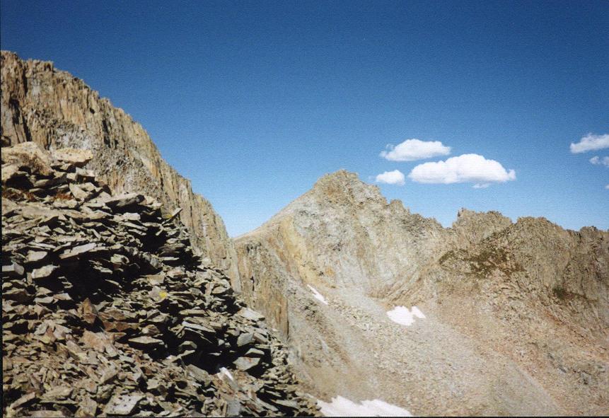
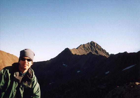
Lavender Peak from the 12,900 foot
saddle just east of Mount Moss.
We drove north into Colorado and took a 9,800 foot high campsite along the approach road into Tomahawk Basin for climbing Lavender Peak - the tentative highpoint of Montezuma County, Colorado.

Monday, August 30

For decades Hesperus Mountain was believed to be the highpoint of Montezuma County. Recent evidence has cast that into doubt - with nearby Lavender Peak possibly being higher by a mere eight feet. The various arguments in favor of each peak are provided in this web page.

Armed with just this information, Edward and I decided that Lavender Peak was the safer bet. We had tried the previous day several times to phone John Mitchler for his assessment, John having attempted Lavender Peak on Saturday with a hand level to make exacting comparisons.

We never contacted John until well after our attempt - an attempt that failed owing to insufficient route information. Details of our efforts to scale Lavender Peak are provided in this trip report.

Tomahawk Basin
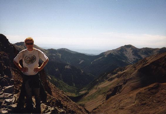
Tomahawk Basin from the high saddle
just east of Mount Moss.
Edward poses in the foreground.
We headed north to the Mount Wilson / Wilson Peak area, passing famous Lizard Head (class 5.9, 13,113 feet) as we drove over the eponymous pass. As the standard Silver Pick approach was closed due to recent landowner concerns, we were forced to choose among several alternate trailheads. Eventually we decided upon the Woods Lake approach from the northwest, and camped slightly down the approach road from the organized campgrounds, at a hairpin bend, to avoid a $12 campground use fee.

Tuesday, August 31

Edward and I were anxious to climb both Mount Wilson and Wilson Peak. The former is considered the most challenging of all Colorado county highpoints with a class 4 summit crux. The latter is currently off-limits along the only reasonable climbing route - the southwest ridge.

Rather than climb these two summits as dayhikes on successive days, we decided to minimize the total elevation gain by establishing a high, backcountry camp within Navajo Basin and within a short distance of both summits. Our 12,000 foot camp would be on permitted ground and would enable each Wilson to be climbed with just a 2,000 foot elevation gain apiece instead of a punishing 5,000 feet.

Mount Wilson
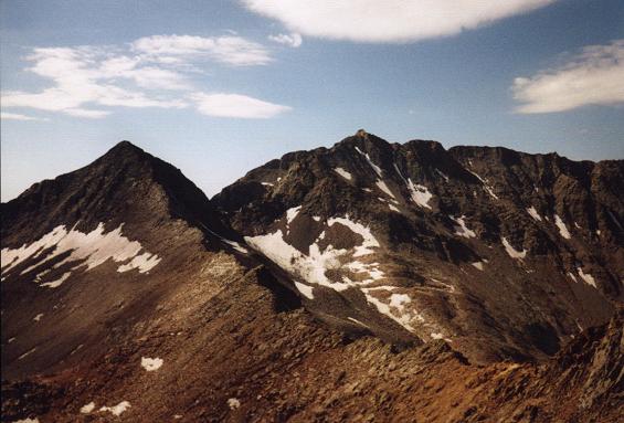
Mount Wilson, center, from the
Wilson Peak southwest ridge.
It took 3 hours 50 minutes to backpack from the carpark, 9,400 feet, to our high camp at nearly 12,000 feet. The skies were nearly cloud-free upon arrival just before 1 p.m. Nevertheless we decided to simply enjoy the afternoon rather than attempt Mount Wilson - afternoon showers with wet rock on the summit bid would be exceedingly dangerous.

It was a glorious day. I enjoyed watching the pikas frolic about, and even placed a section of bagel atop a prominent cairn to see if any would grab. There was much conversation, especially about prominence and climbing Mount Wilson. I enjoyed a granola bar every now-and-then, and we agreed to eat dinner around six o'clock to highlight the otherwise lazy day.

We were in the tent soon around sundown, and asleep just after eight after reading some National Geographic articles and a picture book on Hawaiian volcanology.

Wednesday, September 1

Mount Wilson was a worthy challenge. Details are provided in this trip report.

Edward talked earlier of climbing both Wilsons on the same day. However I noted to him that the resulting morning hike out would not gain us any time since all contemplated climbs required a morning, rather than an afternoon start.

Mount Wilson summit
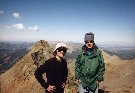
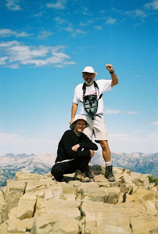
Edward (at photo right) and Adam
atop Mount Wilson. The famous
Wilson-El Diente ridge lies behind them.
We again had a lazy afternoon, and I for one am pleased with the drawn-out experience. Supper was once more around six, with a different menu for each of us, and we slept quite satisfied with our Mount Wilson success.

Thursday, September 2

We arose before sunrise, after first light, around 6:30 a.m. as with yesterday. Details of our Wilson Peak climb are provided in this trip report.

After returning to camp we rested for twenty-five minutes, packed our gear, and headed downhill to the trailhead. I spiked my milk with coffee crystals to keep up with Edward's long stride, enjoying it with a maple flavor granola bar. It is only on descent that his five inch height advantage is an issue, and I sometimes use coffee as a means to level the playing field.

Upon return to the pickup truck we stored our gear apart from a single daypack with one GPS unit, a liter of water and a granola bar. Remarkably, and, indeed somewhat insanely, we continued downhill, paralleling the creek drainage so as to lose additional elevation as rapidly as possible.

Wilson Peak
Wilson Peak viewed on ascent of
Mount Wilson, its southwest ridge
defining the daylit skyline.
Why such seeming madness? Upon "bottoming out" some 200 feet below the truck, followed by regain of the elevation, we would form a closed loop with a 5,000 foot net elevation difference between our lowest point and the summit of Mount Wilson - in essence, the first 5,000 foot Earlization in the county highpoint world.

In so doing, we were assured credit in the corresponding FRL (Front Runner List) records category regardless of the precise outcome of the current debate regarding what constitutes a 5,000+ foot effort.

The pint of Ben & Jerry's Oatmeal Raisin Cookie ice cream was well-deserved on the drive north to a cheap motel room in Montrose that evening. With a microwave oven in the room, Edward elected to have a store-bought pizza for supper ... while I cooked a jalapeño Jack cheese pasta package on the stove top.

Our experience climbing the Wilsons was made more enjoyable through taking our time and enjoying the glorious afternoon weather rather than taking the considerable risk of climbing under potentially threatening skies.

Friday, September 3

An unenjoyable day traveling by bus, culminating in a cell phone call from Dean Molen that he was three hours north on Interstate 15 and would be unable to retrieve me from the Provo, Utah bus terminal for that period.

I arranged a taxi ride to the nearest cheap motel and, without a vehicle of my own, was at the mercy of Dean Molen (and Bob Bolton) for transportation to the next day's venue.

A weather front had passed through, dumping rain through much of western Colorado and northern/central Utah. The snow lingered at the higher elevations, so making it more difficult to climb any of the contemplated ultra summits. The original itinerary specified Mount Nebo for Saturday, followed by Flat Top Mountain on Sunday. Mount Nebo, being higher and farther from the desert, would be more snow-sensitive than Flat Top. Thereby both Dean and Bob agreed with my proposal to switch the two venues, allowing for some snowmelt on Mount Nebo before attempting it on Sunday.

Bob Bolton was a newcomer to the plans. Evidently a trip to Colorado had fallen through with a friend of his, and he decided to join Dean Molen, and thus myself, for a string of ultra summits in Utah.

Saturday, September 4

After repairing a busted tire, Bob and Dean retrieved me and we drove to Flat Top Mountain, highpoint of the Oquirrh Range southwest of Salt Lake City. Brad came, Dean's 23 year old son attending Brigham Young University.

We started walking from the locked gate at 7,900 feet amidst light frozen precipitation. Upon reaching Halls Basin at 8,900 feet it started to rain heavily. Nevertheless we located the trail described by Edward Earl and, under improving weather, made the summit, still within the clouds, some three hours after starting.

summit of Flat Top
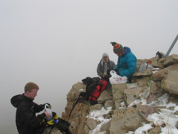
Summit of Flat Top Mtn
in the clouds.
Views were hard to find. It was cold and windy. However I enjoyed my summit lunch, with Spanish Iberico cheese and a chocolate Moon Pie, along with handshakes and the requisite summit photographs.

Upon return to the locked gate we were met by a bow hunter, rightly angered because we had foiled, through our loud conversation, his attempt to claim some animal. Evidently we had unknowingly been on private land, and we were told in no uncertain terms that this was not again to be tolerated. Apparently an alternate approach was on public lands, and this fact should be made known to any future highpointer seeking the summit of Flat Top Mountain.

We are fortunate that the hunter decided not to prosecute the case, and, indeed, we are quite apologetic that his hunt had been compromsied - as well as his family's land.

Dean had a family reunion that evening, as well as the next day, and was deposited in Provo at the relevant hotel. Bob and I drove in vain for a motel room - the weather was still threatening and neither of us had a tent since I had originally planned upon renting a vehicle for my entire stay in Utah.

Locating a room was difficult because it was the season opener for the Brigham Young football team - in some classic battle against the Notre Dame University team. Thousands of fans came from out-of-town, filling up every empty room. We drove well south to Nephi, near next day's Mount Nebo, and found a room at the Motel 6.

Sunday, September 5

Mount Nebo
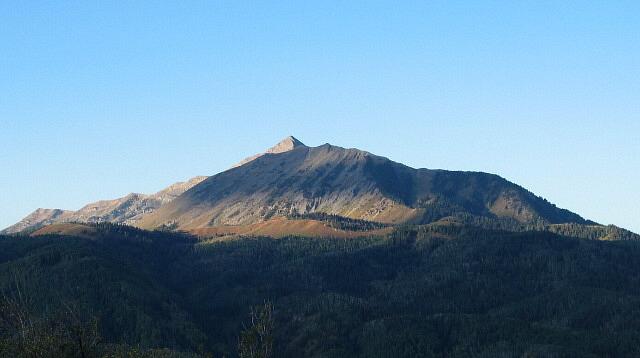
Mount Nebo from the northeast.
Bob Bolton and I climbed Mount Nebo, the Utah County highpoint, using a northern route described previously by Gerry Roach in this trip report. The snow was largely melted, and we enjoyed a marvelous seven hour hike with superlative views from the summit.

Details of our Mount Nebo climb are provided in this trip report.

We got off the trail around 3:30 p.m. and had a long way to drive in order to reach the trailhead for Ibapah Peak, across the state, the next morning.

After finishing the Nebo Loop Road we stopped for refreshments (I insisted) - including a pint of Haagen Dasz coffee ice cream for myself enroute to the Salt Lake City Airport for my rental automobile.

I preferred a more generic flavor, and with less fat than the relatively tasteless Haagen Dasz brand. However it was the only variety available where Bob had stopped - and I did not want to inconvenience him by going next door to a real supermarket for some better choice. I mixed-in a bit from each of six granola bars eaten on-trail, the entire box labeled as some newfangled "cereal and milk" variety pack owing to dried milk inside each bar. Give me a break - the granola bars still needed real milk (or coffee or ice cream) to be enjoyed!

summit of Mount Nebo
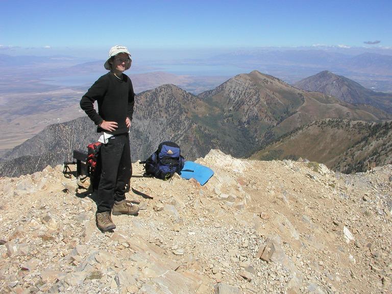
View north from Mount Nebo
summit; Adam in foreground.
Bob and I caravaned to Wendover, on the Utah/Nevada border. This improbable town appears normal on the Utah side ... but then, drive over the state line and all you find are casinos and fast food joints. It is a despicable display of America at its worst - greed, sloth and gaudy display all rolled into one.

I was glad to leave Wendover as we drove south, now by night, to a campground but five miles north of the turnoff for climbing Ibapah Peak. Nighttime dirt road driving in the desert was thoroughly unenjoyable, and I for one felt relieved when we finally parked at eleven p.m.

Monday, September 6 - Utah State Completion

atop Ibapah Peak
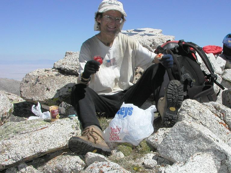
The Utah completion atop Ibapah Peak
with bagel, caviar, cheese and onion.
This was my day on my mountain. I made it quite clear that I was getting to the summit, but would remain with Bob and Dean so long as they maintained a good pace. They did.

Details of our Ibapah Peak climb are provided in this trip report composed by Dean Molen.

We caravaned in our two vehicles (Bob, myself) to the start of the paved road system. It was nearly dusk and I was exhausted from having had only six hours sleep on each of the past two nights. I am quite sensitive to losing sleep. While Bob and Dean drove to Wendover for a room, I just parked at a narrow pullout, ate supper and slept by ten in the proverbial "middle-of-nowhere".

I awoke at 1:06 a.m. feeling very grungy from several days facial hair growth, smelly clothing, and dirty socks. I drove to Wendover and "showered" in a gasoline station Men's room, shaved and changed into fresh socks and tennis shoes. Feeling relieved, I entered the station and left with both a hot chocolate cappuccino and a What-Cha-Ma-Call-it candy bar.

Ibapah Peak
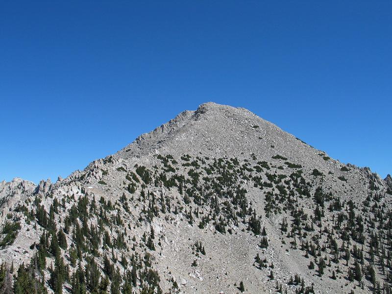
Ibapah Peak seen from the prominent
subpeak on its southwest flank.
After finding a spot in the darker section of some casino parking lot, I slept until 7 a.m., the candy bar slowly consumed whenever I woke up and found nothing else to do but take another luscious bite into the chewy caramel, peanuts and chocolate.

Tuesday, September 7

This was my day-off from climbing ultra summits, an appropriate concept after the one mile vertical elevation gain of Ibapah Peak ... and prior to the 4,800 foot gain of Mount Timpanogos!

No such luxury for Bob and Dean - they climbed Deseret Peak, the Toole County, Utah highpoint, with some 3,600 feet of elevation gain, in what Bob described as their "rest day" (!)

By nine a.m. I was visiting the Bonneville Salt Flats Recreation Area. One is prohibited from leaving the pavement unless part of some speed record-seeking automotive team. The desolation of the area is utter, only flat, salt-laden earth and a few summits in the middle distance.

I considered various tourist venues for the day, including the Hill Air Force Base Museum and Timpanogos Caves National Monument. Instead, I took an "early check-in" at a Motel 6 in Lehi, close to next day's venue, and enjoyed much food and television in the room.

Timpanogos sunrise
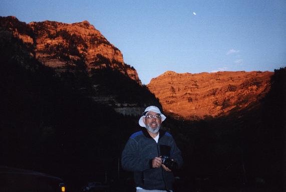
Bob Bolton at the Aspen Grove
trailhead for climbing Timpanogos.
I received a cell phone call from Bob Bolton that evening. He and Dean had not found adequate route information for Pilot Peak, a Nevada ultra summit, and so was set to climb Mount Timpanogos a day earlier than planned. Would I like to join him?

I had planned on the Timpanooke Trail to climb 'Timp, with fourteen miles round-trip and some 4,600 feet of elevation gain. Bob had been recommended the Aspen Grove Trail by Dean, shorter by two miles yet with 4,800 feet of gain.

I had plenty of maps for the Timpanooke Trail. Bob had none at all for the Aspen Grove Trail. It was a tough decision. I called Bob back and said I'd meet him at the Aspen Grove trailhead for a seven a.m. departure.

Wednesday, September 8

I awoke at 5:30 a.m. and drove up the canyon, past Timpanogos Caves National Monument, all by dark. Upon arrival at the trailhead parking lot I found Bob fast asleep in his truck. I was compelled to waken him at 6:48 a.m. and, even then, we were not on the trail under just after eight.

Emerald Lake
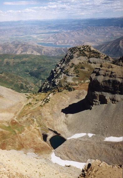
Summit view nearly vertically down
to Emerald Lake. An emergency shelter
is barely visible near the trail junctions.
Bob used this classic hike as an opportunity to "max-out" his camera usage. The entire climb was thoroughly enjoyable, including a long summit siesta, with great views of both nearby ridges and the city of Provo way, way below.

As Bob took innumerable summit photographs, I enjoyed a protracted lunch with my Kraft Roka Blue Cheese, his cream cheese with chives, leftover caviar from Ibapah Peak, chopped onion, french bread, Bob's salty crackers, and a rich, giant chocolate chunk cookie with milk and various snack items from the trail (caramels, hot cinnamon candy, and Nestle's Crunch with peanut butter filling).

The elapsed time for our hike was a tad over nine hours, including all breaks. Back at the carpark I was rewarded with a green fuji apple from Bob, part of which I used for a blue cheese and apple mini-sandwich prior to parting ways. Bob was off to climb the next ultra summit on his plate, Wheeler Peak of Nevada and the centerpiece of Great Basin National Park.

Finding it a good deal, I returned to the same Motel 6 as the previous night. After a shower I visited Albertson's supermarket and enjoyed a pint of Atkin's approved cinnamon ice cream with the appropriate mix-ins. I had purchased this specific pint simply because of its novelty and not because I fear carbohydrate intake. An hour later I had a simple supper with leftover french bread, assorted cheeses, and salami.

atop Timpanogos
Bob Bolton (standing) and
Adam on top of Timpanogos.
Thursday, September 9

My flight to San Diego was overbooked. Upon learning this fact, I immediately signed-up for displacement to the next flight but thirty-five minutes later. This afforded me both a free flight ($113.20) and a $100 voucher on any future Southwest Airlines flight for twelve months.

It was good indeed to receive a $213.20 check for future travel.

I had accidentally left my Swiss Army pocketknife in my daypack carry-on. It was detected and confiscated by the airport authorities. However a system now exists wherein a person can mail himself the item in question by purchasing an envelope and stamps at the nearest gift store. A few days ago the blue pocketknife arrived at my home address.

I thought of Dean Molen climbing Mount Nebo that morning as I watched it pass under the left wing. The change of aircraft in Las Vegas went smoothly, and I was home by noon Pacific Time.

Summary

The Utah state completion speaks for itself. I am pleased to have "acquired" four ultra summits, raising my total to thirty-six in the lower forty-eight states, and fifty worldwide.

It is noteworthy that Bob Bolton indeed climbed eight ultra summits in as many days - so providing the first entry in a new prominence records category for consecutive ascents over a multi-day period.

With Mount Wilson behind me, I now have both the easiest and the toughest of Colorado's county highpoints - the former earned on my April travels through the eastern plains. Much remains in my quest to green the Centennial State - enough to fill several future summertime trips.

Here is my county highpoints completion map resulting from this trip. Note the red for the foiled effort in Montezuma County, Colorado. I wish to fix that bug next summer - and yet will wait for the remaining San Juan Range counties until Edward Earl is ready to come along.