Montezuma County Highpoint Trip Report

Lavender Peak via Tomahawk Basin

Date: July 30, 2005
Author: Adam Helman

Note 1: All NAD27 UTM coordinates are in zone 12S.

Note 2: John Hamann took several revealing and striking photographs of our climb.
              The majority of these are displayed at the Montezuma County photo page.

Note 3: Click on any photograph for enlargement. Full descriptions are given in the
              Montezuma County photo page.

A recently submitted trip report from Layne Bracy corroborates the concept that a Class 3 route up Lavender Peak exists via Tomahawk Basin and the Mount Moss - Babcock Peak ridge (henceforth as "M-B ridge"). John Hamann and I climbed Lavender Peak by this means, indeed, the day after a successful ascent of Hesperus Mountain.

This effort was part of a larger journey collecting Colorado county highpoints in late July and early August 2005.

The Montezuma County "question" has been adequately addressed elsewhere - see Bob Martin's writeup and my previous description composed after a failed attempt on Lavender Peak in 2004.

In the current report I elaborate on Layne Bracy's route description with UTM coordinates for key waypoints and photographic details.

Approach

Tomahawk Basin is accessed from the south. From Durango, drive west on route 160 about a dozen miles to road 124, the 160/124 junction located less than a mile west of the junction of route 160 with route 140.

Alternatively, from Cortez, drive east through Mancos and continue perhaps fifteen or twenty road additional miles to the same 160/124 junction. John Hamann and I drove this way, having just come from an ascent of Hesperus Mountain.

Route 124 is paved for perhaps four miles, and passes through a couple of somewhat small communities. Several pay-for-use campgrounds are located farther along as the now dirt road continues to gain elevation.

The highest campground prior to Tomahawk Basin is located at about 9,700 feet within one road mile of a junction with the jeep road that runs up the desired basin - a road that requires either four wheel drive or a lot of nerve to not simply walk. We camped there, without paying a use fee since facilities were minimal.

It is about ten road miles along route 124 from its origin along route 160 to the jeep road junction - one that forms a severe angle of about 150° with the main road. The junction coordinates are (761676 E, 4145901 N) at 9,900 feet.

Route 124 deteriorates markedly in the few tenths of a mile prior to this junction. Thereby I parked at a wide pullout about one-third mile south, at about 9,800 feet, at a section where the road trends east-west instead of north-south. I recommend that you park similarly - the additional walking is minimal compared with parking at the actual road junction. Besides, there is no space to park at the junction anyways.

Hike and Climb

Walk along the jeep road as it soon turns west up the basin, with several switchbacks, eventually passing the abandoned Tomahawk Mine partway up its course and at 10,800 feet. One hundred feet below the mine is a switchback at 10,700 feet. The switchback is identified by noting the mine above you and to the north.

switchback
The switchback at 11,000-11,100 feet
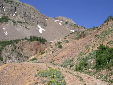
where one exits the road
in favor of a steep dirt path.
(photo courtesy of Layne Bracy).
The switchback has a fire pit immediately south and is a good place for a short break. A usetrail leads into the trees northwest from the switchback, and, when taken, avoids much needless road walking. The usetrail's upper terminus is at the road, yet well above the abandoned mine. I recommend taking the usetrail despite its steepness - it rapidly gains perhaps 200 vertical feet without the boring road switchbacks.

Above the usetrail one profitably continues west on the road until yet another switchback at perhaps 11,050 feet. Here a somewhat steep dirt path leads northwest for about 200 vertical feet, topping out in a flat region, at 11,250 feet, with your first views of the M-B ridge. It is pointless to continue on the road after this switchback if your goal is Lavender Peak. Unfortunately the dirt path is annoyingly steep because it is easy to slip on the dirt at such a high grade. There is no exposure.

waterfall
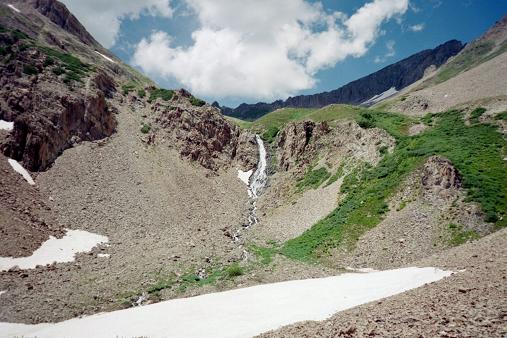
The waterfall at 11,500 feet.
John H. and I cached ice axes at the usetrail's upper terminus, since it was plain that snow was not going to form an obstacle enroute to the M-B ridge.

When in-season a waterfall lies west at 11,500 feet. To bypass it you climb the grassy slopes to the north and northeast thereof. After leaving the steep usetrail, you may be able to locate a hiker's path that continues west, paralleling a metal water conduit for a short time. Then you climb the grass slopes, interspersed with talus, until topping-out on an 11,600 foot bench northeast and slightly above the waterfall.

Moss-Babcock ridge
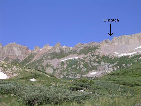
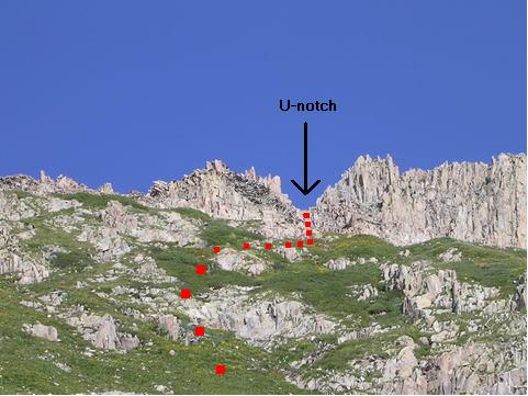
The Moss-Babcock ridge with
recommended U-notch indicated.
(photo courtesy of Layne Bracy).
A pleasant hike with gentle grade takes one from 11,600 feet to 12,000 feet at the head of Tomahawk Basin. To the north lies the steep scree slope leading to a 12,900 foot saddle just east of Mount Moss. This is the route Edward Earl and I took in 2004 - only to find ourselves without a means of surmounting Mount Moss for access to Lavender Peak.

upper basin
View west from 12,000 feet
in upper Tomahawk Basin.
The M-B ridge lies to your west and northwest, and is the ridge you surmount to climb Lavender Peak from Tomahawk Basin. The ridge is pinnacled, and, on the back (west) side, the rock is at times extremely loose and jagged. Thereby you want to access the ridge as far north as possible - indeed, in the most northerly notch visible before the ridge becomes inaccessible, as a sheer, vertical wall, as it climbs the south slopes of Mount Moss.

The recommended point of access is the prominent, U-shaped notch at (758465 E, 4147062 N), at some 12,800 feet, and as highlighted in the photograph.

One may reach this notch by climbing 400-500 feet on grassy slopes, and then diverting right (northeast) to reach the base of a 200-300 foot gully extending down from the notch. Climb the gully and be thankful that you did not access the M-B ridge farther south.

John H. and I learned the hard way where to access the ridge. We met the ridge slightly south of this U-notch, by climbing through the breach at (758467 E, 4147023 N) and at some 12,700 feet. From there we had to descend some 75 feet on the west side, following what appears to be a faint path which subsequently parallels the ridge prior to nearly regaining it farther north. This needless down-and-up maneuver is over extremely loose and jagged rock, and is not recommended. I located the U-notch on our return from Lavender Peak, by a chance look left as we walked the ridge south, and, needless to say, we exited the ridge at the U-notch rather than suffer through that loose rock a second time.

U-notch
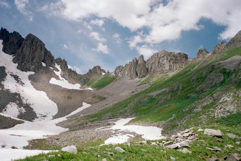
Close-up view of the U-notch
and the gully beneath.
(photo courtesy of Layne Bracy).
The route from the U-notch to Lavender Peak is straightforward. Walk around and over the boulders, ascending very slightly as you traverse the west side of Mount Moss. You may end up climbing fifty feet higher than the desired Mount Moss - Lavender Peak saddle, since a more direct path involves steeper sidehilling and possibly gullies with steep inner walls.

John and I left our packs at the saddle and walked to the base of the final rock pinnacles - an elevation gain of some 400 feet. The westernmost pinnacle is highest. We found access is possible by climbing a steep rock chute for some 75 vertical feet, located on the south side of the pinnacles and in-between the westernmost pinnacle and the pinnacle, every-so-slightly lower, immediately to its east.

Lavender summit area
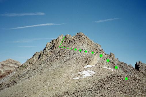
Lavender Peak from near the
Lavender-Moss saddle 450 feet below.
The route is Class 3+ by my reckoning, requiring no ropes but a measured amount of resolve. The rock is, well, "rock solid", with great handholds and foot placements - I dare say, "fun" climbing. A sandwich-size, plastic Tupperware box was found on the north side of the western pinnacle and about one foot lower than the very top. Leveling by eye showed the sister pinnacle, immediately east, to be slightly lower.

summit pinnacles
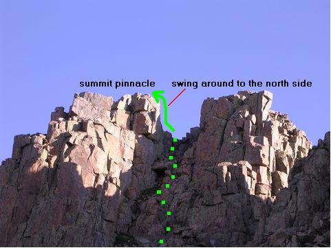
The leftmost pinnacle is highest.
Climb the Class 3+ chute as indicated.
(photo courtesy of Layne Bracy).
From atop the highest point Hesperus Mountain appeared higher - just as had Lavender Peak appeared higher from atop Hesperus Mountain the previous day: a commonly observed optical illusion. However Lavender Peak appeared higher from Hesperus Mountain than did Hesperus Mountain appear higher from Lavender Peak. If I were a betting man I'd place better than even odds on Lavender Peak being the higher. However if somebody came with accurate leveling equipment and declared Hesperus Mountain the higher I would, although surprised, believe the result.

Until said measurement is made, anybody wishing to claim Montezuma County must climb both summits.

Return the route of ascent.