Colorado, Montana, and Wyoming end May early June 2005 Trip Report
© June 2005 Adam Helman
(Click on any image for enlargement.)

Background

The chief goals of this trip were to finish the Wyoming counties on the High Plains, and get four Colorado counties, along the Interstate 25 corridor, that are accessible earlier in the season than other mountainous Colorado counties farther west.

That said, the trip was made more economical, on a cost per county basis, by adding a whole bunch of additional counties located on the High Plains of eastern Montana; and the state highpoints of both North and South Dakota.

I would fly into Denver, rent an economy car, and pursue highpointing for nearly two weeks. This would be cheaper, in the long run, than driving my Tacoma truck from San Diego.

On a grander scale, this trip would edge me closer to an eventual completion of both the Colorado and Wyoming county highpoints.

Overview

My journey ended up full of unanticipated and surprising events. A key factor was the rainy weather, particularly in Montana, which combined with the poor traction of the rental's tires, resulting in cancellation of several county attempts.

Apart from the weather there were several unique episodes in my journey, as witnessed in the detailed review below.

Apart from West Spanish Peak of Las Animas County, Colorado, and Harney Peak of South Dakota, none of my efforts involved climbing a major peak. Then again, serious mountains were not part of the plan to begin with.

I ended up with twenty-two new counties, roughly what I had originally planned prior to several theoretical trip modifications all considered before departure. Specifically, I completed the four desired Wyoming counties; three of the four desired Colorado counties; both Dakota state highpoints; the Badlands and Wind Cave National Park highpoints; and thirteen Montana counties clear up to the Saskatchewan border.

In so doing I "globbed" both Dakotas into my home glob and, as the northeast tip of Sheridan County, Montana, created a new "farthest home glob point" of 1,301 statute miles from my San Diego home.

Furthermore on May 29 I set a new Montana 24 hour speed record with five counties over a sixteen hour period.

All told the rental clocked 3,974 miles - more than the odometer's indicated amount on driving out of Denver. I certainly wore down their vehicle without touching mine - exactly the point!

Trip Details

Thursday, May 26

The flight into Denver featured views of various Colorado ranges. I was gratified to see the snowline at roughly eleven thousand feet - high enough to consider adding back the Colorado counties which recently were replaced by Montana counties on my mental checklist.

The Dollar Rent-A-Car Dodge Neon appeared to have good ground clearance for a passenger car. The tires, however, were, of course, small and had insufficient tread for my uses.

Platte County, Wyoming was the afternoon's venue. Do NOT attempt this county without high clearance - at least for the route that I took, and as provided by Kevin Williamson. The dirt road driving was long, consuming three hours one minute from the paved highway. After passing the Miller Ranch one is left with grassy two-tracks to negotiate. My vehicle threatened to "bottom-out" on several occassions, with nasty and even frightening sounds heard beneath the car as dirt, tall grass, and even rocks pounded the undercarriage.

The two highpoints are trivially reached after parking at the fence, with a locked gate, at the county line. Here is a trip report with details of Platte County.

An emotional wreck, and tired from having arisen at 4 a.m., I took a motel room in Lusty, Wyoming - the Rawhide.

Friday, May 27

The Weston County, Wyoming highpoint was simple enough. Here is a trip report with details of the experience. I pounded a Russian fifty ruble coin into the fencepost along the South Dakota / Wyoming state line - as is traditional for this county. It is located on the west side of the fencepost about one foot from its top.

I drove into South Dakota and was stopped on the approach to the Crook County, Wyoming highpoint by a road block just one mile along the Forest Service road - "Closed for the public safety." Thirty miles later enroute to Badlands National Park I stopped at a Forest Service Visitor Center and learned that recent rains had destroyed some of the road - and that repairs would not be effected during the length of my journey. I purchased a Black Hills National Forest map in the hope that an approach from the west side of Cement Ridge, one week later, would be successful.

bison
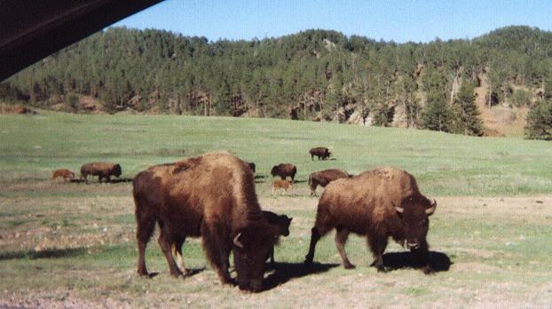
A pair of bison along the road
in Custer State Park.
(click for enlargement).
On approach to Mount Rushmore National Monument I found everything highly commercialized - so much that it disgusted me. I drove up the entrance ramp for paying the $8 parking fee, and then, ascertaining the views to be disappointing, shoved into reverse and backed out. Man's work pales in comparsion with that of Nature.

The Badlands National Park highpoint was accessed by a twenty minute round trip walk from the road immediately west, as route 40/41, starting from just north of where the road descends to the south. Here is a trip report with details of the experience.

I continued in a clockwise loop, now along SD highway 18, west and then back north to Wind Cave National Park. I barely missed (by about three minutes) the last cave tour of the day, which had departed at 4:30 p.m. After leisurely enjoying the Visitor Center, I purchased two books - one each on Wind Cave and Badlands Parks. I then drove the short distance to Rankin Ridge and hiked up the fire tower approach road to the Wind Cave highpoint.

bison
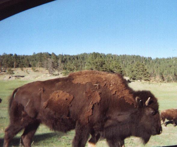
A large bison just outside the right
window in Custer State Park.
(click for enlargement).
Driving to my next venue, Harney Peak, took me through Custer State Park. A herd of bison straddled the road. I cautiously approached in the Neon, and they made room for the car as I took some photographs. This occurred a second time a few miles later, with a motorcycle gang looking on as they waited out the bison's movements prior to driving in the opposite direction.

Campgrounds near Harney Peak all had a $15 pricetag. I drove a few miles south back into the national forest, and parked for free, legally, at an empty logging site just barely off the highway.

Saturday, May 28

Harney Peak was hiked using trail #9, starting from the parking lot on the east shore of Sylvan Lake. Time to summit was (I believe) 1 hour 6 minutes. This peak would pose Class 5 challenges, at least from the south, were it not for the solidly constructed metal stairs on the final 100-200 vertical feet or so. I imagine that in icy weather the staircase route demands your attention.

The drive southeast on highway 87 is spectacular for the first 2-3 miles. Volcanic plugs and other geologic wonders are roadside, one that curves and twists repeatedly through bizarre and unusual terrain. At one point the motorist is surrounded by interesting boulders that loom overhead in a 360 degree arc - an ampitheatre of sorts. I highly recommend driving this portion of highway 87 immediately southeast of the Harney Peak area.

Eventually I drove through Rapid City; then headed west on Interstate 94 to an exit for Belle Fourche and points north along highway 85 - the goal being North Dakota's state highpoint.

I found Amidon to be empty of services on this Memorial Day weekend. I drove the two-track south until a gated fence, parking just as two state highpointers were departing.

The weather was blustery, blowing wind and a sky which threatened rain any moment. I hightailed it to the top, taking only fifteen minutes for the ascent - and perhaps ten or twelve for the return. This might be a record time for White Butte!

Being only 3:30 p.m. I drove west, and, at a nearby town, encountered the same pair of highpointers at the gas station. I continued west into Montana and parked at the gated entrance to the ranch Jobe Wymore describes in his trip report for Fallon County.

Nobody home. I reparked my car one-half mile west along the approach road's shoulder, far enough away that, being around a bend in the road and hidden by some hilly terrain, the horses which had accosted me at the ranch gate would not see the car and come to bother me yet again. I penned a note to the ranch owner explaining my intentions, added a $20 bill, and placed them in a plastic baggie affixed to the windshield wiper.

Most days I stopped driving around 7:30 or 8 p.m. - enough time to eat supper while still daylight and seated in the left rear; and then lie down across the entire seat around 9 p.m. as light waned. I would awaken in the middle of the night to get into my sleeping bag, which always felt better than sleeping with just my parka. In so doing my pillow shifted from sleeping bag in its stuff sack to a real pillow.

Sunday, May 29

This was the longest in a set of long days. I suspected that a Montana one-day speed record was possible with adequate weather, and some good luck. I awoke at 4:15 a.m., ran the car defrost to clear the windshield ice layer, drove the short length to the ranch gate, affixed my note, and was hiking around 4:40 a.m.

After a navigational error that took me south instead of southeast, and wasting perhaps twenty minutes, I eventually reached the two Fallon County highpoints cited in Jobe's report. Then I made a beeline for the ranch - which I reached around 6:30 a.m. and found to yet be void of people.

My boots were wet and muddy - and I changed into fresh, dry socks. I then drove away, wearing only the clean socks, with boots placed on the floor of the passenger seat area facing the foot compartment air vents. The wet socks went atop the dashboard on the air vents for the defrosting mechanism. The defrost was turned on, with the heat on as well, and the fan at the second highest of four settings. In so doing the car immediately reeked with the stench of dirty socks - and yet, within twenty minutes, the socks were nearly dry and well enough to use the following day. The boots also dried quickly enough that I could use them within a few hours. The smell was quite disagreeable - but not quite bad enough to vomit.

Wibaux County was next, consuming about ten minutes for the short hike. It was only 9:20 a.m.! I took a half hour nap soon afterwards, in the town of Wibaux, just prior to a driving a short section west on I-94 to exit 213 in Glendive.

Around noon I "did" Richland County, hitting all four areas in a roughly 4 1/3 mile hike. It started to rain the final half mile. I HATE rain. I HATE it passionately. Here is a trip report with details of the experience.

Sheridan County was a two mile round-trip hike, and, as usual, rain sprinkles ruined the enjoyment of this experience. Sheridan is the farthest county from my San Diego base of any in my home glob, as it is the most northeastern county in Montana.

The Daniels County highpoint is only two miles from Canada. I walked the north-south road for one-half mile, as described in Jerry Brekhus' trip report and concluded the effort just before 8 p.m. I then drove back west on North Bench Road about 2-3 miles, finding an abandoned home on the south side immediately west of where the road drops down a hill.

I parked at the home. I unlocked the bolt and found it was a former Bingo hall! Given the very remote location, I suspect that much illegal gambling had taken place here, away from the eyes (and long arm) of the law.

Five counties after sixteen hours. I called my parents on the rented satellite telephone; ate supper most happily; and slept as the light waned around 9:30 p.m.

Monday, May 30

These northernmost Montana counties are very underpopulated. Both Daniels and Valley Counties feature almost no people apart from the small communities of Scobey and Opheim, respectively. The remoteness was nearly equal to southeastern Oregon; or of central Nevada; but not quite since the rolling, green farm countryside appears more "human friendly" than desert and sagebrush.

After a coffee-spiked double serving of hot cocoa at the only cafe in Opheim I drove onto the gravel road grid for the northern six contours of Valley County. The grass two-tracks were negotiable.

I then headed for the remaining, southern contours. I found ancient vehicle tracks headed straight for some of the highpoint areas - presumably left by the previous efforts of another highpointer, such as Bob Packard with Bob Martin. By careful sighting I determined that some of the contours need not be visited.

I completed Valley County by 10:20 a.m. and headed onwards to Roosevelt County. These three contours were hiked in a twenty minute round trip, my vehicle parked just southeast along the southern edge of the plowed field.

Dawson County was next - but not before more showers threatened success on the road approach. I drove and hiked to all relevant contours - finishing at the set of three contours on the far east. Here is a trip report with details of the experience.

I eventually parked at what appeared a gravel pullout on Dawson CR205 about 2.5 miles south of the gravel road leading ten miles east to MT 200S. My goal the following day was McCone County. By 10 p.m. is was apparent that I could get stuck there due to the persistent rains. So I woke up and drove to Lindsay, a small town without services, and parked on asphalt at a grain elevator complex.

Tuesday, May 31

It rained all night. I awoke at 5:30 a.m., easily already daylight, returned to my former sleeping location, and then continued west on the four mile stretch of road described by Bob Packard in this trip report. After just one mile, and at a farm house immediately north, I encountered deteriorating road conditions, including mud, that forced cancellation of McCone.

As I drove past Lindsay, five miles southeast at mile marker 19 on MT 200S the left rear tire gave out. I had seen a nail embedded in the sidewall a day or so earlier, and had left it in place lest this occur. It was raining hard. There was really no safe place to pull off the road - making it very dangerous to change the tire myself due to traffic in either direction.

The satellite telephone proved valuable in this circumstance. After about one hour (during which I ate dried mango and cashews in the driver seat) a gasoline station serviceman arrived with the appropriate heavy duty repair equipment. I acted as flagman, directing any oncoming vehicle past the repair, while the serviceman changed tires, using the spare "runt" provided by the rental company.

We caravaned to Glendive and his Shell service station. I was compelled to purchase a matching new tire since I still had thousands of miles to travel - and to do so on the small-sized spare was not recommended in the owner's manual. After both hot chocolate and a Mississippi Mud ice cream bar (with almonds) I drove west on Interstate 94. The approach road, Sheep Mountain, for the Prairie County highpoint had the ominous warning, "Minimal maintainance road. Proceed at your own risk." True enough, within one mile I encountered mud which made the vehicle difficult to control. I scratched yet another county.

Given the above pair of mud-based encounters, I considered it futile to even attempt driving the thirty or so miles of dirt road to the Garfield County highpoint.

All told I had zero to show for the day. In compensation the drive on MT 12 from Forsyth to Roundup, some 102 miles, was both sunny and full of pretty country views - a glorious reprieve from the morning's events. I took a motel in Roundup and enjoyed heating my food in the room's microwave oven.

Wednesday, June 1

I was at the service station just after it opened at 5 a.m.; had coffee; and was soon hiking Petroleum County.

Then came the two liners of Mussellshell County. No problems here either.

I drove south to Billings, in the rain (often heavy), and negotiated the eleven miles of gravel / dirt along Cormier Road as described in Jerry Brekhus' trip report for Yellowstone County.

I noted a squall line approaching from the west as I neared the highpoint. It appeared ominous - exceedingly thick and with rain descending from it at a slant. I RAN back to the car; threw my pack onto the back seat, and drove like HELL back on Cormier Road lest I get caught in the mud by the approaching storm cell. I bought time whenever the road took a jog east - so placing me farther from the threat. Once at the paved Blue Creek Road I parked the car; slumped back in my seat, and just let the rain play havoc with my senses.

NO JOY

Back into Billings I gassed up and headed east on Interstate 94 all the way to the exit for highway 39 and Colstrip. My aim was to examine a western approach to the Custer County highpoint for the following morning. South of Colstrip I entered a storm cell that was so dark, at 4 p.m., that it looked nearly black as night itself. The weather deteriorated markedly, eventually with hail, 30 mph winds, and water blowing in sheets across the paved highway. I parked for about ten minutes until the very worst had passed.

Just east of Ashford I started up the red gravel and dirt road for Custer County. I quickly decided to turn back owing to the threat of rain making the road impassible. I continued east on MT 212, passing through a construction zone (is THIS a state highway?), and then took a room in Broadus for the night. The weather was not cooperating in the least.

Thursday, June 2

I really wanted to get at least one of Carter and Powder River Counties. This would connect the blue glob recently constructed in northeast Montana, including the North Dakota highpoint, with my home glob. Unfortunately the approach roads, leading to the nearly nonexistent town of Ridge, would doubtless be impassible to my vehicle - one that is all too easily rendered impotent by recent rain.

So I took the bold step of hiring a local man to drive me in his 4WD truck to the highpoint areas.

The price was a tank of gasoline for his truck. Lloyd is a retired man who goes on safari as a guide during the hunting season. A high-powered rifle accompanied him on the front seat - as well as some homemade elk jerky that I found neither salted nor slightly sweet like most commercial varieties. It was not that tasty.

Lloyd knew personally the rancher and landowner for Powder River County. On greeting one another, the rancher denied access to the easier of two contours because he was trying to move his heifers, located thereabouts, to near a bull located elsewhere. My presence would scatter the cows.

It makes no sense at all to get just one contour, since the second contour has to be then be done, anyways, at a later date for claiming the county. Getting just one is therefore functionally equivalent, in terms of time, distance traveled, and expense, as getting nothing at all.

Staying low inside gullys and eventually hiding my bright red daypack altogether, I nabbed the forbidden contour, radio mast atop, all the while concerned that I'd be spotted. You see, it is one thing to simply stealth hike without having met the landowner. In contrast, I have never heard of somebody going forward with his hike after being told point blank not to do so. It took a lot of chutzpah on my part. I view the occassional stealth hike as part of the county highpointing equation.

Lloyd received the appropriate lie as to why I had taken so long for a presumably two mile hike to a single hilltop - my GPS unit had run out of power and hence I could not determine which of several hills was the true highpoint. Thereby I "did all of them". As a precaution I reversed the orientation of one battery so that upon examination the GPS unit really could not turn on.

We drove to West Butte, the Carter County highpoint. A ten minute round trip saw me both at the main area, and at the bump immediately east for insurance purposes.

We returned to Biddle, where I had parked my rental to avoid backtracking north. We enjoyed cold sodas and then parted ways.

I had complete success that afternoon with a western approach to the Crook County, Wyoming highpoint. The Black Hills National Forest map was helpful, and I found the gravel roads to all be in excellent condition. A short hike southeast with about 300 feet of elevation gain found me on top of Cement Ridge. Here is a trip report with details of Crook County.

I drove to Gillette and slept, in my rental car, in the back lot of a warehouse near the railroad tracks.

Friday, June 3

I had trouble locating the track heading east up and eventually up the northwest slopes of North Pumpkin Butte - the Campbell County, Wyoming highpoint. I parked my vehicle on the gravel approach road; hiked in the general direction of where the track was supposed to be; and eventually located it. Here is a trip report with details of Campbell County.

The road is good to walk upon, and as a navigational aid; but I do not feel that anything short of an ATV can safely travel it any longer. This track begins immediately south of where the southeast-trending approach road crosses a gully. The track exits the white gravel road by heading north, entering the gully where it promptly gets covered in grass and mud as it turns northeast.

I called Dave Covill on the rented satellite telephone, from the western radio antenna a ten minute walk northwest from where the road tops out on the butte. He was enroute to Las Vegas and Telescope Peak with his son. Huckleberry chocolate; kosher bologna; and a pair of granola bars composed my lunch meal.

On the drive south to Colorado I turned on the car radio and, remarkably, tuned into KOA Denver, at 850 kHz, some 300+ air miles away at the junction of Wyoming 387 and 59. Although KOA is a full 50,000 watts, it is unusual for daylight AM band reception to exceed 200-250 miles.

The weather conditions reported for northeast Colorado were bad indeed - thunderstorm activity and even a tornado watch. As I drove south the conditions worsened before my eyes. When I learned that Denver was experiencing a major storm, during Friday rush hour, I decided to halt my southward progress and, somewhat reluctantly, take a really cheap room in Cheyenne for the night. Even there is was raining - but not the flooding reported on The Weather Channel for Interstate 25 through Denver.

Holed-up in my room for the evening, I turned on my portable shortwave radio and tuned into KOA while watching television. Unfortunately KOA broadcasts the Denver Rockies baseball games - so I was unable to receive any weather updates that evening.

Well, at least I had completed the four remaining Wyoming counties on the High Plains.

Saturday, June 4

A telephone call to the Pikes Peak Road maintainance number yields a taped message recorded on Thursday morning - made all the more annoying because the message claims to be updated "every 24 hours". I took my chances and drove through Colorado Springs, then west on route 24, to the entrance booth. The road was open for 13 of the 19 miles to the summit. I needed 16 miles to get me to the Devil's Playground - roadside highpoint of Teller County. I was not allowed to hike the road for the remaining three miles past where it was open because it could disturb the snow plowing vehicles.

After receiving a 2-3 hour estimate I drove to Manitou, made some telephone calls, including a congratulatory message to Edward Earl on the first anniversary of his Mount McKinley ascent. I took a nap.

Upon return I learned the road was still not open past 13 miles. A cooperative Forest Service man suggested that I pay $5 (the charge for when the road is not open to the summit) and drive up anyways, timing my arrival with when the road would be opened.

After waiting but a few minutes at the Glenn Picnic area and store (13 miles), the road was opened and I took it clear to 13,000 feet - parking for my venue. I dressed warmly, took my ice axe in case of hard stuff, and did the short hike. Other people headed in groups of two or three to the rock outcrop. They all, of course, had no idea that it is the Teller County highpoint.

Some interesting observations on human behavior were made. None of the adult tourists cared to hike the distance, one that featured a rope obstacle halfway along, as if the rock outcrop was either too dangerous or otherwise off-limits. Ridiculous. Only teenagers hiked. Do they have a more adventurous spirit than adults? Or do they simply have more energy to burn off, sitting couped up in a car? Who can say. One girl, roughly high school age, appeared colder than all the others. She was extremely skinny, about like myself in that regard, and I wondered if a correlation exists therein with cold intolerance. Her boyfriend handled the cold and wind more easily.

I was gratified to find a pair of young adults who had climbed up the 3,000 feet from the Crags - a trailhead on the west side. They were the only ones, apart from myself, adequately dressed for the venue.

The remainder of the day saw me driving south to Las Animas County for West Spanish Peak. I camped at Cucharas Pass, some 9,900 feet, after verifying that the gravel approach road to Cordova Pass, the standard trailhead, was open.

Sunday, June 5

The trail was partly snow covered while in the trees. At treeline, and at the mountain's west ridge, snow was no longer an issue as I cautiously climbed, using the occassional cairn to verify that I was indeed on the correct general path. I reached the summit after 3 hours 3 minutes. Dropping my pack I walked the snowy summit ridge to the eastern bump since the snow cover made it appear higher. After a satellite telephone call to my mother I ate lunch.

I had plenty of time to investigate Otero County - which had foiled me in April 2004 owing to mud. I found the road through Comanche National Grasslands to be dry. However, as with Platte County in Wyoming, my vehicle made alarming noises when driving over the high-centered track.

I hiked the five possible highpoints, proceeding east to west, hitting every bump along the mesa's south rim so that I would be assured of "the" county highpoint without having to ascertain my position with GPS unit at every hilltop. I walked very briskly, even though the sky was almost completely blue, likely because I was energized more than normal from the snacks enjoyed at the Trinidad gasoline station.

At the westernmost high point on the county line I headed 1.57 GPS miles directly southeast to my car - which was visible as a white speck amidst the green.

On driving out I mistakenly took a ranch road heading south instead of east, at the 4.5 mile mark in Dave Covill and John Mitchler's description in their book, Hiking Colorado's Summits. I realized my error when the terrain was not recognized and when I continued to head south rather than east. I more or less panicked. What IF I were to become grounded-out, HERE, with the vehicle. I don't even have MAPS to tell somebody where I AM! And the towing or vehicle extraction fee would be considerable.

I turned around, drove back over a dry river bottom that, again, was not present on the inbound drive, and eventually located the correct track leading east. Negotiating the road where it enters and exits the river bottom was not something for a low clearance, 2WD vehicle. I truly worried that the rental company would locate structural damage and charge me thousands of dollars in repair bills. So when I finally returned to highway 350 I parked; examined all tires and the chassis as best I could, finding nothing out-of-whack or even loose.

I drove a few miles northeast on route 350, then one mile south to an Iron Springs Historic Marker "in the middle of nowhere". I camped there, nearby cows staring at me for quite some time.

Monday, June 6

I awoke around 5 a.m. and drove northeast towards La Junta. I found a timesaving bypass road, as route 71, that took me to gasoline in Rocky Ford and hot chocolate. Then west on route 50, through Pueblo, bound for the Forest Service approach road to Greenhorn Mountain - the Pueblo County highpoint. From great distances on the plains I could see that snow was minimal except at the very top.

Just one mile along FR369, past its junction with FR643, I encountered a locked gate with the sign, "Road closed to preserve soil and water resources". What kind of BULLS*** is this? This is MY National Forest land, and I am being restricted from enjoying it.

I was about fifteen miles from the summit. Scratch Pueblo County.

Adam and rocks
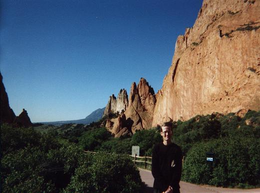
Myself at Garden of the Gods State Park.
(click for enlargement).
To ascertain the true reason for the road closure, in particular whether it was permanent, I drove to the Isabel National Forest Office in Cañon City. Were the closure permanent then I'd might as well hike an alternate trail from the southeast the next day, with a 5,000 foot elevation gain. Were the closure not permanent, then I might as well use the remaining time to enjoy other venues - and then efficiently reattempt the highpoint, with an open approach road, on a future trip.

Turns out that "150% normal snowpack" was the excuse provided - and that I could try again the following week. Too late, of course. What upsets me is that I bet the road WAS snow-free, but that nobody had cared to check it out for a while. So, yeah - BULLS***.

With no more counties avaialable except in the high country farther west (and hence snowed-in), I decided to enjoy the remainder of my time with non-highpointing activities.

I drove back to Manitou Springs and took the Pikes Peak Cog Railway to the summit. It was certainly fun - although it cost $28. One hour up; one down. I enjoyed six scoops of ice cream at the base station waiting for the train's departure. At the indoor summit concessions I enjoyed a hot bowl of macaroni and cheese - to which I added chopped onions, wasabi horseradish, and ketchup - much to the amusement of the British tourists. I had eaten not from hunger (how could I be with all that ice cream). Rather, I ate because of the novelty in a hot, ready-to-eat entreé at 14,000 feet. I also bought ten ounces of fudge in four varieties. Fudge has the advantage over chocolate of not melting in the summer heat.

The motel room in downtown Colorado Springs suffered from having no functioning lock on the door.

Tuesday, June 7

rock formation
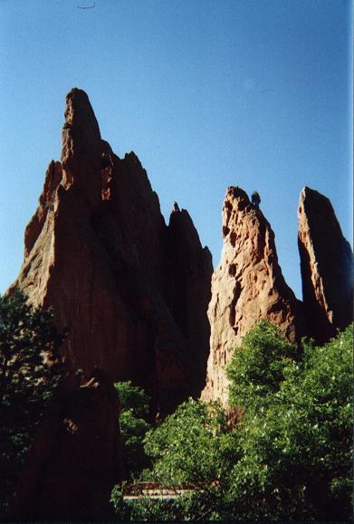
A typical sandstone rock formation
in Garden of the Gods State Park.
(click for enlargement).
In the morning I hiked around the Garden of the Gods just west of Colorado Springs. I took many good pictures, one being of Balanced Rock with Pikes Peak in the background. To acheive this effect I had to park the car at a very specific location and stand on the rooftop.

I drove north on Interstate 25 and climbed Castle Rock in the eponymous town. A hiking trail leads from the base in corkscrew fashion. It suddenly ends immediately UNDER the summit cap rock with no obvious method of approach. Park benches are located under the summit cap, and there is a partly destroyed railing visible high on the south face - but with no simple means of getting there as if the city park authorities had allowed the summit trail to vanish without either the funds or the desire to reconstruct it.

I left my daypack and found a fun class 3 route up the south side. After all of thirty vertical feet I was on top, walking north to the obviously highest spot of ground alongside a giant electrified star that must light up at night.

balanced rock
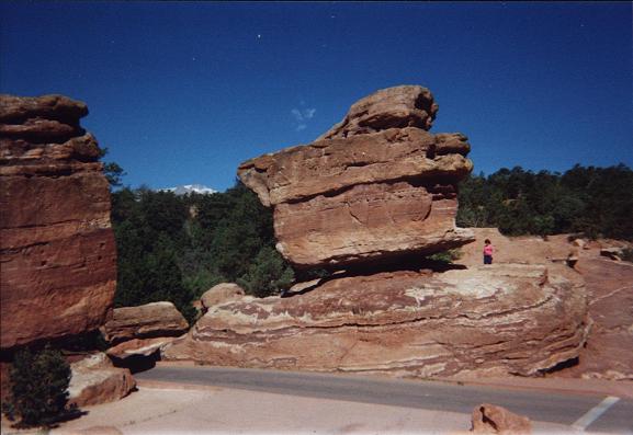
Balanced Rock with distant Pikes Peak
in Garden of the Gods.
(click for enlargement).
I drove to Denver, thence west on Interstate 70 and highway 58 to Golden. I returned to John Mitchler's home where I had been in April 2004. Finding nobody home I left a note in the front door stating that I had come by to say hello.

I spent about four afternoon hours at the American Alpine Club Library in Golden. I introduced myself to the librarian on-duty, and explained the prominence concept to him as a means of trying to learn if any book at-hand had EVER addressed similar concepts. We located none. I did, however, find Andy Martin's County High Points book in the reference section - appropriate for a book of lists.

The main item gleaned from visiting the library is that my upcoming prominence book is a completely unique offering.

I slept at the American Motel near Exit 267 along Interstate 70. As noted in a previous report, their rates are quite low provided advance reservations are made.

Wednesday, June 8

The flight home was uneventful, apart from seeing the Mount Evans highway beneath the right window as the Frontier Airlines jet passed overhead - already at some 20,000 feet.

Here is my county highpoints completion map resulting from this trip.
Note the cross-hatched violet and green, representing concrete plans to complete Oregon on my next trip.

Epilogue

Upon reading this story, a highpointer made the following comments that I find sufficiently illuminating to include here.

Hi Adam: Nice job on your trip and trip report. Since you put so much work
into the report (although I get the feeling you enjoy "re-living" the trip
while writing a report--I know I do), I thought you deserved some personal feedback.

Some comments:

"I would fly into Denver, rent an economy car, and pursue highpointing for
nearly two weeks. This would be cheaper, in the long run, than driving my Tacoma
truck from San Diego."

I, too, have gone this route. I also rented a Neon and drove it places where
no Neon should ever go, and likely has never gone before or since.
While driving my Neon across field tracks near the MT-ND-SD tri-state point,
it started making terrible noises whenever it was turned even slightly.
I rode that way, holding my breath for 300 miles, to the next place where I could
get it fixed. Turned out a piece of something shielding vital parts
underneath the engine had been bent and was rubbing against something else.
Fixed in 10 minutes, under warranty!

Earlier in that same trip, I also experienced the fun of losing all traction
on a muddy dirt road. Felt just like driving on ice. Twice I got out and
poked away most of the mud with a hiking pole, but it accumulated again almost
immediately. Downright scary. Once back on pavement it is fun to watch and
hear the mud come flying off.

Next time out west, I got smarter. Drove to Omaha, a quick day and a half
ride from NJ. Parked at the airport for $3/day. Rented a real 4WD Mitsubishi
for about half of what it would have cost in Denver, and drove all over the
west on a major "glob" trip. Lessons learned: 1. It is always worthwhile to
spend the extra bucks for 4WD and high clearance, if there is any chance they
will be needed. Cheaper than coming back a second time. Also a LOT easier on
the nervous system. 2. On this kind of trip, check out alternate starting
cities for cheaper flights and rental cars.

"On approach to Mount Rushmore National Monument I found everything highly
commercialized - so much that it disgusted me. I drove up the entrance ramp for
paying the $8 parking fee, and then, ascertaining the views to be
disappointing, shoved into reverse and backed out.
Man's work pales in comparsion with that of Nature."

My feelings exactly the first time I visited. I returned a second time with
my family, who had not seen Mt. Rushmore. Much to my surprise, I enjoyed the
second visit a lot. Go figure. Maybe it was just relief at not seeing Ronald
Reagan smiling blankly at me from the mountain.

"The defrost was turned on, with the heat on as well, and the fan at the
second highest of four settings. In so doing the car immediately reeked of this
bad stench of dirty socks - and yet, within twenty minutes, the socks were
nearly dry and well enough to use the following day. The boots also dried quickly
enough that I could use them within a few hours. The smell was quite
disagreeable - but not quite bad enough to vomit."

No doubt some of our more delicate souls will be offended by this subject
matter, but it brings back memories of my high school buddy who discovered the
merits of this drying technique, while my other buddy and I accompanied him in
his 1960 Chevvy. We only averted vomiting by hanging our heads out the windows.
The memory of that sweet aroma haunts me 40 years later.

"Staying low inside gullys and eventually hiding my bright red daypack altogether,
I nabbed the forbidden contour, radio mast atop, all the while
concerned that I'd be spotted. You see, it is one thing to simply stealth hike without
having met the landowner. In contrast, I have never heard of somebody going
forward with his hike after being told point blank not to do so. It took a lot
of chutzpah on my part. I view the occassional stealth hike as part of the
county highpointing equation."

You are a very naughty boy. No doubt that landowner is a stealth member of COHP,
and the highpoint police are on their way to your home as you read this.
Maybe we should establish a bail bond fund, with members of COHP as guarantors.
Never having been turned down flat by a landowner, I have not had to
duplicate your stunt, however I would do so in a heartbeat. An essential stratagem
is to have a good lie made up in advance in case you get caught. In your
situation, you could always claim you were doing some highpoints on adjacent land
and got lost or disoriented. That, plus a bribe, might actually work.
I think the best thing we have going for us is that most landowners are busy people
and don't want the hassle of calling the cops and dealing with all the
aggravation. Most of the time they will just bust your balls for a while, then send
you packing. Of course if you get a real first-class prick.......

"We drove to West Butte, the Carter County highpoint. A ten minute round
trip saw me both at the main area, and at the bump immediately east for
insurance purposes."

I did this one in a snow squall, which made it fun. By the time I got back
to the car, the sun was out. I can tolerate snow squalls, but like you I take
rain personally. It has no part in the highpointing experience.

"On the drive south to Colorado I turned on the car radio and, remarkably,
tuned into KOA Denver, at 850 kHz, some 300+ air miles away at the junction of
Wyoming 387 and 59. Although KOA is a full 50,000 watts, it is unusual for
daylight AM band reception to exceed 200-250 miles."

KOA does seem to reach out a long way, even in daylight. Maybe the paucity
of other stations in the area helps out. If you enjoy right-wing talk radio,
KOA makes for good company. In my case, I only tune in on the hour to grab a
weather forecast.

"I had plenty of time to investigate Otero County - which had foiled me in
April 2004 owing to mud. I found the road through Comanche National Grasslands
to be dry. However, as with Platte County in Wyoming, my vehicle made alarming
noises when driving over the high-centered track."

I, too, drove that "road" in a rental Neon. Never again.
I had the same morbid thoughts of having to hoof out and summon help.

One request: Tell me about the satellite telephone rental.

So Adam, when are you going to start extending your glob toward the Atlantic Ocean?
I detect a case of glob fever, and humbly recommend you send a tendril
this way. When you arrive in the urban jungles of the east, you will be
welcomed appropriately.

Best, M