New England May 2012 Trip Report
© June 2012 Adam Helman

Note 1: All coordinates use the WGS84 datum.
Note 2: Mouse-click most images for detail.
trip map
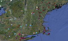
Dynamic trip map
(Click image to view.)

Background

An ascent of Alberta's Mount Columbia was the preferred venue - yet a critical mass of participants was unobtainable. Synchronizing access-sensitive New England venues to fit within a two week journey then becomes the issue. Fortunately this was achieved, with dates set as May 20 at Barnstable County, Massachusetts and May 23 for Sullivan County, New Hampshire. The former county's highpoint is on a military reservation; the latter in a private hunting club.

These arrangements prepare me for twin completions of their respective states' county highpoint lists. In addition three other goals are envisioned - I secure a ridiculously cheap car rental out of Manchester, New Hampshire ($264 for 14 days, unlimited mileage), so determining my flight itinerary. A giant figure-8 driving loop results, first southwest to the Catskills and New York City; then northeast to complete Massachusetts at the pair of island counties; back north to New Hampshire to complete that state; into Maine as noted; and finally back to Manchester.

Trip Details

Wednesday May 16 to Friday May 18 - Outbound Flights and Catskills

Three flights lead to Manchester via Denver and Cleveland. I arise at 4 a.m. for the first leg, out of San Diego - so by the time my rental car is secured, around 9:30 p.m., I am unhappy to commence driving towards my first goal.

Still, at 6:30 a.m. the next morning I'm alert - no small feat given the three hour time shift as at home I often go to sleep at 1 a.m. just 2 1/2 hours earlier on my "internal clock". It typically takes me two days to time-shift during a journey so as to make proper use of daylight without an absolute need for artificial stimulation, a.k.a. coffee.

summit shack
Hunter Mountain summit building

Hunter Mountain of Greene County is a breeze - I take the steeper Becker Hollow Trail, finding myself on the flat summit ridge after just one hour or so. Details of my effort are found in this trip report.

Finished around 4 p.m. I can drive the hour-or-so and do Slide Mountain before darkness. However what's the rush?

After supper I settle-in on the rental's back seats for the night, using a sleeping bag to soften rough edges more than for its warmth. It's a trial. NO position is truly comfortable, and I awaken quite often to shift around .... looking forward to daybreak so that this small piece of misery can conclude.

Eventually I am rewarded - and Ulster County's Slide Mountain is mine to enjoy - the Catskill's highest and thus most topographically prominent mountain. New details of the route are found in this trip report.

However I am finished by only 9:10 a.m. There's plenty of time for a pair of county highpoints as I head south towards the New York City area. I choose Rockland County, visiting its twin pair of potential highpoints mid-afternoon. Then I car-camp at a small dirt lot just off the main east-west paved road through Harriman State Park. Some details of my Rockland County effort are in this trip report.

Saturday May 19 - New York City Dash

This day has a long preamble. I've known Mike Schwartz only electronically for literally years - yet this is the first time we'll actually meet in-person. Then too I've met Lanny Wexler only once while he was in Denver just prior to an ascent of Colorado's highpoint Mount Elbert.

TODAY I am their guest, being chauffeured through the navigational tricks of greater New York to no less than nine county highpoints - a personal record for one day.

It was not planned that way ... we are simply very efficient. The original concept was to do seven counties as the five NYC area boroughs plus Nassau and Suffolk Counties on Long Island. All that accomplished by about 2 p.m. we had plenty of time for crossing into New Jersey for Union and then Hudson Counties - but not before I enjoy a pint of newfangled "Waffle Cone" ice cream - "fudge covered waffle cone pieces with a caramel swirl and Hershey's mini chocolate chips".

Jayne Hill boulder
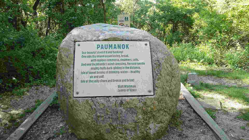
Boulder atop Jayne Hill (Suffolk County).
Mouse-click to read from "Leaves of Grass".

More counties still could have been conquered. However as Lanny noted in his own detailed review, a Phillie cheesesteak is not kosher - while New York corned beef and pastrami are. So we head into Manhattan, locate (most luckily) a parking space, and pig-out at Ben's delicatessen. I order the "I cannot decide?" plate which includes your choice of three appetizers as main dish. However each one seems like a full-sized plate by themselves! On seeing this feast set before me I decide that it's quite insane to consume all of it ... so I set aside one-half of each dish as take-out and enjoy the balance.

There's knish, kugel, kishka, kasha varniskas and kreplach. No kidding! Plus a plate of Polish-style tongue. Lanny has an overtopped sandwich piled ridiculously high with corned beef. Mike has a dinner - perhaps it is roast beef? I forget. Anyhow, for dessert I order apple strudel, Lanny orders chocolate babka (huge and served warm so the chocolate is melting everywhere), Mike has tea, and we three share both desserts. I must admit that babka is exquisite... yet would be even better with vanilla ice cream. However THIS is a meat-only (nondairy) restaurant!

Concerned that I might be unable to walk after all of this food, we instead amble some six city blocks to Times Square amidst a throng of tourists. Peering up at the enormous electronic billboards I comment, "This is all interesting. But give me the summit of Old Speck!" - a reference to some Maine peak planned for a week later.

Clock Tower
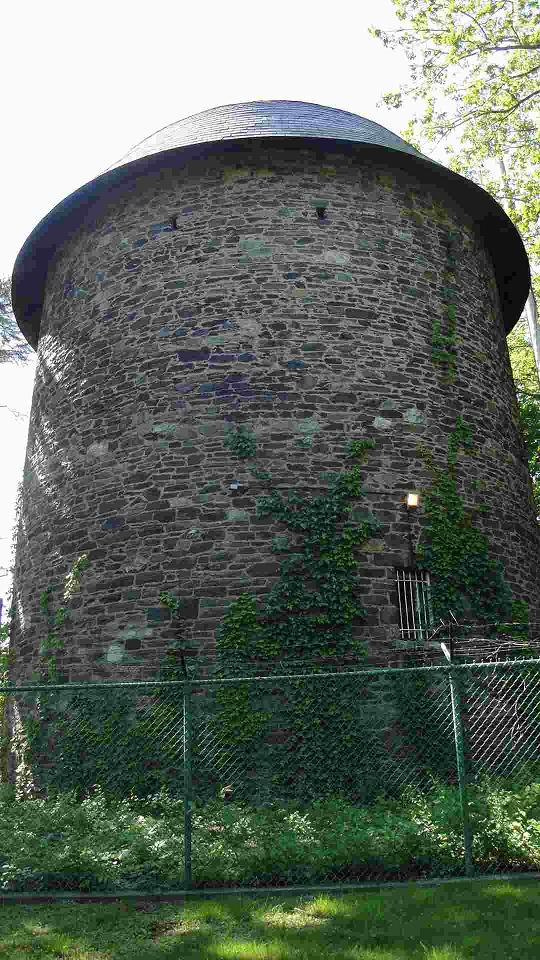
Clock Tower of Nassau County

Here is Lanny Wexler's detailed review of this day.

After weeks of planning which involved whether to do the highpoints by transit or by car, selecting a safe meeting place to leave a car for the day, explaining to Adam the New York and New Jersey quirks of navigating EZ-Pass and jug handles, the long heralded trip to the metro New York/New Jersey County Highpoints got underway.

This one day in New York was part of a bigger Northeast trip for Adam to hike the Catskill highpoints, complete Massachusetts and New Hampshire - as well as getting a good part of Maine done. Originally Adam planned to do Nassau, Suffolk, Queens, New York, Bronx, Kings and Richmond but Lanny suggested Union and Hudson as easy add ons that enabled Adam to break his one day County Highpointing record by two and for Lanny by 0.5.

The main issue with these highpoints was access as a number of them were on a private property and would take some chutzpah.

Suffolk County: Jayne Hill – Adam, Lanny and Mike met at Christopher Morley Park in Manhasset, NY on a gorgeous Saturday morning. Adam and Mike left their cars at Christopher Morley Park and Lanny took his Toyota Prius. Lanny came with tasty Danish and coffee which we enjoyed enroute.

This is our first of what would be nine county highpoints for the day. We arrived at the entrance to West Hills County Parl and found the entrance gated. Lanny suggested doing the western area first and coming back later and perhaps the gate would be open.

We drove around to Sweet Hollow Road and did the bushwhack. It was a short bushwhack through brushy woods to attain the western area. We drove back to West Hills County Park, arriving there at 8:35 am only to find the entrance still gated. Not really a problem. Mike and Adam walked the third of a mile up the road and paved bath to the Jayne Hill boulder. Lanny decided to make the trek to Jayne Hill afterwards after an Asian couple encouraged Lanny to leave his car parked by the side of the road. It would only take 10 minutes.

Nassau County: Clocktower Lane and Harbor Hills - Lanny was without a home! After visiting 219 counties and impressive peaks like Mount Whitney in California and Kings Peak in Utah Lanny had yet to claim his home county. What held Lanny back all these years? Private property access issues. Vising the multiple Nassau County highpoints meant walking up driveways and walking through backyards in some exclusive neighborhoods that Lanny was not quite up to. Lanny dreaded knocking on a door to ask permission to walk in someone’s backyard to visit the highpoint for fear of shame of being labeled to be some sort of “nut”.

North Shore Towers
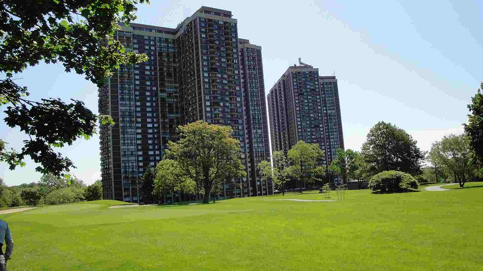
North Shore Towers near the Queens County highpoint.

Well, this was all to change. Lanny would soon have a home glob. Spooky Mike had done a “dry run”, two weeks earlier and found the home at the Nassau County highpoint, 50 Ash Drive was unoccupied and being completely renovated. The first stop was Clocktower Lane - a very exclusive area in Old Westbury. Lanny stopped his car at the end of Clocktower Lane, whence Mike led Lanny and Adam up a driveway to a boulder on the side of the driveway as the highpoint. Calling it good enough, a car pulled into a neighbor’s driveway as they were walking back to Lanny’s car. Lanny anxiously trying to leave as soon as possible almost left Adam behind.

We drove on to the Harbor Hills highpoints in East Hills. We crested Ash Drive and stopped in front of #50. Mike noted that the two points across the street from 50 Ash Drive were lower (IBI, "Ignore By Inspection"). We all exited Lanny’s car and boldly strode up the front lawn and into the backyard of 50 Ash Drive. We walked through the backyard and a wooden deck and called it our own. We then drove around the block to Redwood Drive. It was determined that highpoint was lower than Redwood Drive, then we went on to the water tank. The water tank, also on Redwood Drive is on public property that is accessed off a driveway leading from Redwood Drive. The dark stone tower was restored in 1996 and made a rather impressive photo for the Nassau County highpoint.

After 21 years of county highpointing Lanny had finally “come home”!

The Queens highpoint was another “nail biter”. Adam was not satisfied with the sidewalk highpoint off the south service road of the Grand Central Parkway. This meant we would have to enter via a service entrance and walk into North Shore Towers in plain sight of a guard booth, then through some brush and a golf course. Thankfully, the walk to the Queens highpoint went uneventfully. The guard must have been asleep. We found the geodetic marker and walked across the 17th tee before returning to Lanny’s car.

Mike, Lanny, Adam
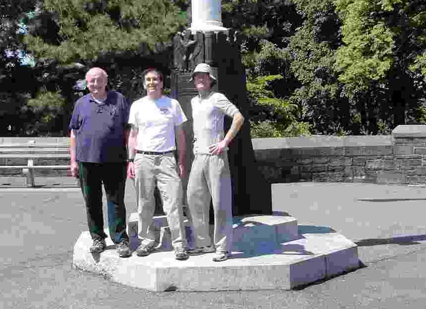
From viewer's left at the New York
Borough highpoint - Mike Schwartz,
Lanny Wexler and Adam Helman.

Off to Manhattan! Lanny expertly negotiated the maze of roadways. Lanny stopped on Fort Washington Avenue in front of Bennett Park while Adam and Mike did “their thing”, hopping the fence and walking to the stone that marks the New York highpoint. It took all of 10 minutes. Then we drove north to Fort Tryon Park to do the Manhattan highpoint by the Cloisters. This was the day's beauty highpoint. The gardens were in full flower and views of the Hudson and Harlem Rivers; the Bronx and the New Jersey Palisades could be seen from Fort Tryon Park. We stopped for a photo by the flag pole.

On to the Bronx and another forbidden highpoint. We exited off the Henry Hudson Parkway passing many orthodox Jews who were walking to and from synagogue. There was even one orthodox Jew davening (praying) in the middle of the street! An exclusive development called Villa Nova Estates is under construction. Recently, access to the Bronx highpoint became much easier as Grosvenor Avenue has been extended north. The boulder marking this highpoint can be accessed by simply driving up to a gate at the end of Grosvenor Avenue and then walking up a hill between a house and the gated area and following the high ground up to the boulder. All this time a guard parked in a car on the other side of the gate observed us without challenging us.

We left the Bronx and drove down the west side of Manhattan encountering some traffic. We drove past the Freedom Tower and through the Brooklyn Battery Tunnel - the day's “low point” enroute to Greenwood Cemetery. Greenwood Cemetery is an interesting place with many famous people buried there including Charles Ebbetts, owner of the Brooklyn Dodgers. We drove past the Battle of Long Island Monument. We parked the car and took a short stroll up Reservoir Hill to the Kaimie Mausoleum - the Brooklyn and Kings County highpoint.

Freedom tower
Freedom Tower nears completion.

We exited the Greenwood Cemetery and stopped at a Hess Station where Adam bought a pint of ice cream. Then we drove across the Verrazano Bridge to Todt Hill, the highest point of New York City at elevation 410 feet. It's not much to look at, being overgrown with briars and poison ivy with a few abandoned cars thrown in.

It was 1:30 pm when we finished Staten Island at Todt Hill; only a mere five hours since we started at Jayne Hill in Suffolk County. The day was still young so why not do more county highpoints?

Lanny had identified Union County and Hudson County highpoints as two New Jersey "gimmes". Union County has two points; one is a water tower and the second point is on a pitcher’s mound of the Governor Livingston High School. Union County would be our highest points of the day reaching the nose bleeding altitude of 560 feet. We drove to the first point passing by a neighborhood block party. For the second point we had to walk about a third of a mile from the parking lot to the pitcher’s mound where we passed a high school lacrosse game in progress.

Kaimie Mausoleum
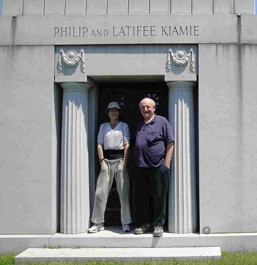
Mike and Adam at the
Kaimie Mausoleum of
Kings County (Brooklyn).

There was still plenty of day ahead and Lanny, Adam and Mike could have continued to tack on highpoints, probably adding 4 or 5 more on and perhaps reaching Philadelphia by sundown - but this county highpointing spree was supposed to be about New York - not Philadelphia. At day's end we were supposed to end up at a kosher deli to dine on corned beef and pastrami - not on Philly cheesesteak. By the way: Philly cheesesteak ain’t kosher :-).

So we turned back to do one more highpoint - Hudson County located atop the Palisades. Hudson was the ultimate easy of gimmes. It was two points in the middle of the block on 67th and Madison Streets respectively. The biggest issue was finding a parking spot. You could have driven to the middle of the block, opened the car door, stuck your two feet out, tapped the pavement and called it good. That’s how easy Hudson was.

After getting some cheap “Jersey gas” we drove through the Lincoln Tunnel and miraculously found a parking spot near Ben’s Deli. We dined on New York staples such as corned beef, pastrami, knishes and kishka; topping off the meal with chocolate babka! Then it was a stroll through Times Square only several blocks away to do some ogling at the sights.

We drove back to Christopher Morley Park, reaching there shortly before dusk. Adam checked with a Nassau County cop if he could sleep overnight in his car and much to his good fortune the answer was yes. We said our goodbyes after a rewarding and memorable day.

                - Lanny Wexler

I sleep in Christopher Morley State Park near the Long Island Expressway (Exit 36), having won the approval of police officers using the lot as their staging area between patrols.

This was a very very fun day .... and even Lanny got a special reward by completing his home county, Nassau, through a newly-found chutzpah that allows him to trespass with the best of us!

Sunday May 20 and Monday May 21 - Massachusetts

It's a five hour drive largely on Interstate-95 from Long Island to southeastern Massachusetts. There I'll meet five other highpointers at 3 p.m. for Barnstable County's Pine Hill on Camp Edwards. However I am at Plymouth County by 11 a.m. only one-half hour away. So I "do" its highpoint, all-the-while locating a route which minimizes any bushwhack for reaching the second, more southerly candidate. Details are found in this trip report.

Steve and Adam
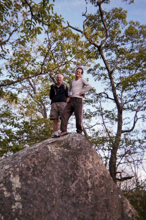
Steve Brown (viewer left)
and Adam atop a boulder
near the Peaked Hill summit.

Barnstable is wholly trivial, laughingly so. However achieving access is NOT that easy. Indeed, highpointer Ben Lostracco (of Quebec) now finishes Massachusetts and all of New England - presumably his final county because of this difficult access. Congratulations....

I calculate that my partners for the twin island counties have time, now, for Dukes County rather than on Tuesday morning as planned. We merely need to make the 6:15 p.m. outbound ferry ... and so, after a taxi ride to Radar Hill, we "summit" Peaked Hill after a ten minute walk. Details are found in this trip report - an important one as it describes the parking situation for how to access The Steamship Authority ferries.

We return to the mainland and sleep in our cars at the ferry parking lot.

Next morning we are up before sunrise to make the first slow ferry departing Hyannis for Nantucket Island. My default driving-morning treat of coffee / hot chocolate with matching snack food seems essential as-always, even if only in a psychological sense.

lighthouse
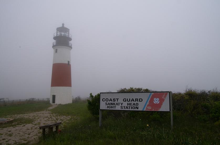
The lighthouse at Sankaty Head
of Nantucket Island.

The boat ride complete, Steve Brown and I rent mountain bikes on Nantucket Island, David Olson having brought his bicycle from home. We first visit Sankaty Head, taking about one hour to get there. Two of three 108 foot contours are visited - the final, most southerly one being observed lower.

Now we consider Folger Hill, inland, because some day it might become the county highpoint. It's an arduous affair with sand and dirt for a good portion of the route. In addition I am upset by the bicycle seat which is quite painful to sit on. The other guys either did not have this problem or decided to not mention it. So why are bicycle seats designed the way they are rather than having a more "normal" shape?

I loath the very thought of mounting the bike after every break to check coordinates or investigate a high point area. Worse still are the cobblestone streets within town - so bad, in fact, that on returning the bicycle (now raining), I ride on the sidewalk with its smooth surface.

My completion of Massachusetts was basically ruined by our selection of transportation mode. However I have important details of how to access Folger Hill in this trip report.

With some half hour before our return boat we spend a lot of money for a little seafood at the closest restaurant. Although the clam chowder is wonderful, and the fried clams with tartar sauce as well, it's simply a jip if I ever saw one.

We part ways until meeting again in New Hampshire for Croydon Peak. I sleep at a large pullout along Route 3 halfway towards those twin bridges leading to the bulk of Massachusetts.

Tuesday May 22 to Friday May 25 - New Hampshire

Today, Tuesday, is the worst weather day of my journey. The 200+ miles driving into New Hampshire is a thankless task, and yet fortunately it's not raining on reaching the day's venue as Rockingham County. New details are available in this trip report. I get a motel room to dry my disgustingly grungy clothing and shower. Besides, it's no fun car-camping in the rain.

I arrive very early to our rendezvous point for Sullivan County, well before the 1 p.m. meeting time. Lo and behold Roy Schweiker arrives as an unexpected guest. He's here just to meet people, such a myself, for the first time. We have an extended conversation for some ninety minutes. Steve Brown comes - as does our host Gerry from the hunting club. Although David Olson has not appeared, I decide after conferring with our host to wait the 40 minutes anyway as our chances are not thereby diminished.

The hike is uneventful, taking one hour for the ascent and less still for getting down. Steve Brown completes New Hampshire here - and again congratulations are in-order.

A few details of the effort are available in this report.

vista * vista * vista *
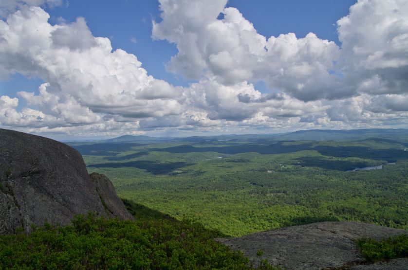
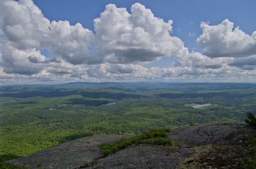
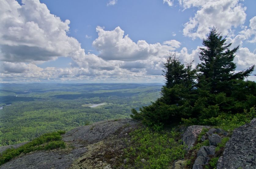
Croydon Peak summit panorama
by Steve Brown.

I sleep at an abandoned ski lift's parking lot as the current "trailhead" for Strafford County via a western approach. The next morning I hike both Strafford and Belknap Counties, and finish by late morning. New details of these efforts are in this report (for Strafford) and this report (for Belknap).

In theory there's time for my final New Hampshire county this afternoon.... however I find it more prudent (yet "unfun") to wash my clothing and check Internet-based weather using one of the laundromat's computers.

I check out my chosen trail for Carroll County. After one-quarter mile it appears to disappear at a stream, presumbly continuing on the opposite side. Not wishing to waste time next morning verifying such an important item, I return with thongs, cross (this is cold!), and return to the car confident of my route for tomorrow.

I complete New Hampshire under blustery conditions, inside cloud and with a chill wind. The weather improves on descending just 500 feet or so. Overall the climb lasts nearly 6 hours - long enough that I am fortunate to have not attempted it yesterday afternoon. Important new details of my route are available in this report.

I drive into Maine under marginal skies and camp at the large parking lot for Oxford County's Old Speck. The weather clears overnight to some degree.

Saturday May 26 to Wednesday, May 30 - Maine and Return Flights

I take the Eyebrow Trail, starting quite early - far more so than any of the hikers I'll see later this morning. One section has a hand railing, another has bolts in the rock for foot placement. After descending about 100 feet I meet the Old Speck Trail which is one small part of the lengthy Appalachian Trail.

The route is often on angled boulder slabs, and nearly all is wet. It's dangerous footing - and so I generally walk on the trail's margins where hundreds or thousands have created narrow soil, leaf and moss-covered paths which are somewhat safer to negotiate than wet, tilted boulder slabs.

I climb the summit fire tower only to find no views above the forest cover. However skies clear as I sit for my summit treat - a individual-sized blueberry pie enjoyed with Australian 3 year cheddar cheese.

My descent is uneventful, returning entirely via the Old Speck Trail. By now the day is sunny and beautiful as I remove the disgustingly sweaty shirt to drive without one - vastly more comfortable that way. There's a huge gathering of hikers on this Memorial Day weekend, ranging from boy and girlfriend to entire Boy Scout troop to whole families with three generations represented.

auto rental
This Toyota "Yaris" is one
bedroom with excellent gas mileage.

As usual, I am the only one traveling alone. New details for this hike are available.

There's time for both Androscoggin and Kennebec Counties this afternoon. Details of these efforts are respectively available here and here.

I camp at a public boat dock. At 1:45 a.m. a drunken driver throws his empty "Mike's hard lemon cider" bottle at my rental for some reason I'll never know. Suddenly I'm bolt upright shouting obscenities - and then on goes my headlamp trying to read his rear plate as the driver, clearly astonished, rushes back to the main road. Barefoot I leave the car and examine its surface in every detail - unable to locate a dent. That's fortunate indeed as I would be responsible for the repair since I never purchase insurance when renting an auto - in turn because it nearly doubles the rental rate.

Four county highpoints today - Sunday the 27th. I expected to do three - yet there is easily enough time for Sagadahoc County as well, sleeping in my auto right next to the summit communications tower of Whitten Hill. Now I just did, in order, Lincoln, Waldo and Knox Counties - followed as noted by Sagadahoc. However I claim that an efficient highpointer can do fully six in one long day by starting with Androscoggin's highpoint at the break of dawn, followed by Lincoln County, and continuing with the four counties noted.

A few new details are available for Waldo and Knox Counties.

On Memorial Day I awaken and find myself having "breakfast pizza" some ten miles after arising. This combination of scrambled eggs, dead pig and gooey cheese is most satisfying. The ensuing Cumberland County effort has new route details described in this report, and similarly here for York County. I am delayed about one-half hour in Limerick town by a Memorial Day parade which blocks access to my approach route.

By 3 p.m. I am finished with 30 county highpoints and take a room in South Portland, Maine with considerable satisfaction. The next day I have no interest in sightseeing as it's raining on-and-off and I've kind of burned-out from having traveled without respite for the past 12 days.

I drive the 100 miles to Manchester, New Hampshire with plenty of spare time Wednesday morning for my 2:25 p.m. flight to Dulles Airport in Washington, D.C. The flight to San Diego is delayed about 90 minutes on account of some idiotic miscommunication between air traffic control and the pilots wherein a flight plan was computed for San Francisco. We taxi to the runway, prepared to lift-off, only to return to the gate for refueling so our aircraft can take a more circuitous route well south of the Upper Midwest where nasty weather prevails.

During the cross-country flight I use my GPS unit to record some three dozen waypoints documenting our route. It is great fun to "save" a waypoint and then press "go to" so that the indicated "hiking" speed would be something like "500 miles per hour"! This keeps me from getting bored ... and, significantly, I record the pilot's efforts to climb above severe turbulence in Texas. We climb to 39,800 feet before descending quickly to about 36,500 feet upon entering extreme southeast New Mexico. The bouncy ride subsides, and we have "clear sailing" straight to San Diego.

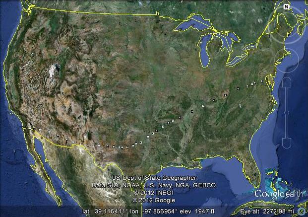
Mouse-click this map to view the flight route using Google Earth software.1
return flight
1 Upon viewing the route in Google Earth, exact coordinates, elevations
and times are available by hovering over a point and left-clicking.
Thereby one may calculate mean ground speed between adjacent points.

Summary

The rental's odometer initially read 2,911 miles - and 4,827 miles on its return for a total of 1,916 miles driven. In addition there are roughly 150 miles in Lanny Wexler's automobile as we hit sixteen high point contours for nine counties.

After completion of my 13th and 14th states I look forward to something a bit (or significantly) more challenging. Five Maine counties remain for a New England list finish. Still the trip was both fun and worth meeting the people I've heretofore only met electronically.

Here's to completing the western states this July and August!