New Mexico State Flag New Mexico County Trip Reports
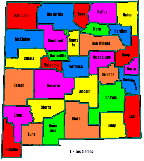
 New Mexico County Map

USA Map / Home Page                         Click on any county for highpoint information

Of the 33 counties in New Mexico 2 pairs share common highpoints.
All New Mexico county highpoints were completed by Andy Martin
as of 1995. The state has since been completed by Bob Martin,
Bob Packard, Mark Nichols, Jobe Wymore, Adam Helman, Ken Jones,
Scott Surgent, Bill Schuler, Edward Earl, John Kirk, Richard Carey,
Gerry and Jennifer Roach; and Dave Covill.
First Ascent List Disclaimer


    topographic chart (Acme)     aerial photograph (Flash Earth)                     Explanation

topo chart / aerial image scale:     normal     regional overview


Bernalillo County - Sandia Crest (10,678 feet)

        topo chart / aerial image

Catron County - Whitewater Baldy (10,895 feet)

        topo chart / aerial image        

Chaves County - One Tree Peak (7,089 feet)

        topo chart / aerial image         photo

Cibola County - Mount Taylor (11,301 feet)

        topo chart / aerial image

Colfax County - Little Costilla Peak (12,584 feet)

        topo chart / aerial image

Curry County - unnamed point (4,792 feet) on northernmost border with Quay County

        topo chart / aerial image

De Baca County - Loma Alta, two areas (5,583 feet)

        topo chart / aerial image        

Doña Ana County - Organ Needle (8,980+ feet)

        topo chart / aerial image         photos

Eddy County - unnamed point (7,480+ feet)

        topo chart / aerial image        

Grant County - McKnight Mountain, two points (10,165 feet)

        area 1         area 2

Guadalupe County - BM Leon (6,339 feet)

        topo chart / aerial image

Harding County - Sugarloaf Mountain (6,455 feet)

        topo chart / aerial image        

Hidalgo County - 1/2 mile S of Animas Peak (8,565 feet)

       
highpoint details - by Scott Surgent.

        No trip reports have been posted.

        topo chart / aerial image        

Lea County - unnamed point (4,476 feet) on Mescalero Point NE 7.5' USGS Quad

        topo chart / aerial image        

Lincoln County - Lookout Mountain (11,580 feet)

        topo chart / aerial image

Los Alamos County - unnamed point (10,480+ feet) on Caballo Mountain

        topo chart / aerial image

Luna County - Cookes Peak (8,408 feet)

        topo chart / aerial image

McKinley County - Cerros de Alejandro, BM Alejan (9,166 feet)

        topo chart / aerial image        

Mora County - Truchas Peak (13,102 feet)

        topo chart / aerial image         photos

Otero County - Sierra Blanca Peak (11,973 feet)

        topo chart / aerial image        

Quay County - Luciano Mesa (5,560+ feet)

        topo chart / aerial image

Rio Arriba County - Truchas Peak (13,102 feet)

        topo chart / aerial image         photos

Roosevelt County - unnamed point (4,780+ feet) on Peach Canyon 7.5' USGS Quad

        topo chart / aerial image        

Sandoval County - Redondo Peak (11,254 feet)

        topo chart / aerial image

San Juan County - Beautiful Mountain (9,388 feet)

        topo chart / aerial image

San Miguel County - Elk Mountain (11,661 feet)

        topo chart / aerial image         photo

Santa Fe County - Santa Fe Baldy (12,622 feet)

        topo chart / aerial image

Sierra County - McKnight Mountain (10,165 feet)

        topo chart / aerial image

Socorro County - South Baldy (10,783 feet)

        topo chart / aerial image

Taos County - Wheeler Peak (13,161 feet and State Highpoint)

        topo chart / aerial image        

Torrance County - Manzano Peak (10,098 feet)

        topo chart / aerial image        

Union County - Sierra Grande (8,720 feet)

        topo chart / aerial image         photo

Valencia County - unnamed point (8,960+ feet) on Torrance County border

        topo chart / aerial image        


Disclaimer

Attempting to reach some of the points listed in this web site can be dangerous, and could lead to accidents resulting in injury or death. Some of the summits lie in rugged and isolated regions, where even minor mishaps can escalate into a life threatening crisis. Other locations lie on private property, military bases, and other areas where access is restricted. Trespassing in these areas can result in being arrested, shot at, or worse. Right of access to these areas is constantly changing, and access in the past does not guarantee present access. By use of this web page, the reader hereby releases the trip report authors, trip report compiler, and webmaster from liability for any injury, including but not limited to monetary loss, death, and other damages that might in any way be connected with this web site.

FAIR WARNING: These are "armchair mountaineer" articles, an offering for amusement, not action. Many of these peaks are potentially life threatening, or are on private property. Adequate mountaineer training and/or owner's permission are required if you choose to pursue this list. The authors cited on this page accept no responsibility for injury, or any liability related to these route descriptions.


State Hyperlinks / Text-only Home Page Introduction Highpoint Superlatives
Highpoint Maps Topographic Prominence Highpointer Celebrities Disclaimer