Montana State Flag Montana County Trip Reports Montana County Map

All Montana county highpoints were
completed by Bob Packard as of 2004.
Jim Perkin's Montana Highpoints Journal
(Microsoft Word)
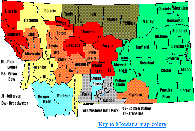
                        Click on counties for highpoint information.
First Ascent List                         Key to Montana map colors


    topographic chart (Acme)     aerial photograph (Flash Earth)                     Explanation

topo chart / aerial image scale:     normal     regional overview


Beaverhead County - Tweedy Mountain (11,154 feet)

        topo chart / aerial image

Big Horn County - unnamed on state line (9,257 feet)

        topo chart / aerial image

Blaine County - unnamed point (5,960+ feet)

        topo chart / aerial image

Broadwater County - Mount Edith (9,480+ feet)

        topo chart / aerial image

Carbon County - BM Plateau on Castle Mountain (12,612 feet)

        topo chart / aerial image         photos

Carter County - West Butte (4,450 feet)

        topo chart / aerial image

Cascade County - Long Mountain (8,621 feet)

        topo chart / aerial image

Chouteau County - Highwood Baldy (7,670 feet)

        topo chart / aerial image

Custer County - unnamed area (3,780+ feet)

        topo chart / aerial image

Daniels County - spot elevation (3,132 feet)

        topo chart / aerial image

Dawson County - spot elevation (3,474 feet) and several areas (3,460+ feet)

        spot elevation 3474         area 2         area 3         area 4         area 5         area 6

Deer Lodge County - West Goat Peak (10,793 feet)

        topo chart / aerial image

Fallon County - two points (3,620+ feet)

        area 1         area 2

Fergus County - Greathouse Peak (8,681 feet) and Old Baldy (8,680+ feet)

        Greathouse Peak         Old Baldy

Flathead County - Mount Stimson (10,142 feet)

        topo chart / aerial image         photos

Gallatin County - Wilson Peak (10,705 feet)

        topo chart / aerial image

Garfield County - two points (3,660+ feet)

        area 1         area 2

Glacier County - Mount Cleveland (10,466 feet)

        topo chart / aerial image

Golden Valley County - unnamed point on north county line (8,640+ feet)

        topo chart / aerial image

Granite County - Warren Peak (10,463 feet)

        topo chart / aerial image

Hill County - Baldy Mountain (6,916 feet)

        topo chart / aerial image

Jefferson County - Crow Peak (9,415 feet) and Elkhorn Peak (9,400+ feet)

        Crow Peak         Elkhorn Peak

Judith Basin County - Big Baldy Mountain (9,175 feet)

        topo chart / aerial image

Lake County - McDonald Peak (9,820 feet)

        topo chart / aerial image         photos

Lewis and Clark County - Red Mountain (9,411 feet)

        topo chart / aerial image

Liberty County - Mount Brown (6,958 feet)

        topo chart / aerial image

Lincoln County - Snowshoe Peak (8,738 feet)

        topo chart / aerial image         photos

McCone County - unnamed area (3,440+ feet)

        topo chart / aerial image

Madison County - Koch Peak (11,293 feet) and Hilgard Peak (11,280+ feet)

        Koch Peak         Hilgard Peak area 1         Hilgard Peak area 2

Meagher County - Mount Edith (9,480+ feet)

        topo chart / aerial image

Mineral County - BM Quartz (7,770 feet)

        topo chart / aerial image

Missoula County - Peak X (9,369 feet)

        topo chart / aerial image (shown as "Lowary Peak")

Musselshell County - north and west county line (4,900+ feet)

        area 1         area 2

Park County - Granite Peak (12,799 feet and State Highpoint)

        topo chart / aerial image         photos

Petroleum County - spot elevation (4,032 feet) and two points (4,020+ feet)

        spot elevation         area 1         area 2

Phillips County - Antoine Butte, three points (5,720+ feet)

        area 1         area 2         area 3

Pondera County - unnamed point (8,440+ feet)

        topo chart / aerial image

Powder River County - two areas one mile apart (4,420+ feet)

        area 1         area 2

Powell County - Mount Powell (10,168 feet)

        topo chart / aerial image

Prairie County - two points (3,600+ feet)

        area 1         area 2

Ravalli County - Trapper Peak (10,157 feet)

        topo chart / aerial image

Richland County - four areas (2,940+ feet)

        area 1         area 2         area 3         area 4

Roosevelt County - three points (2,900+ feet)

        area 1         area 2         area 3

Rosebud County - spot elevation (4,807 feet)

        topo chart / aerial image

Sanders County - Snowshoe Peak (8,738 feet)

        topo chart / aerial image         photos

Sheridan County - spot elevation (2,771 feet)

        topo chart / aerial image

Silver Bow County - Table Mountain (10,223 feet)

        topo chart / aerial image

Stillwater County - Mount Wood (12,649 feet)

        topo chart / aerial image         photos

Sweet Grass County - Mount Douglas (11,282 feet)

        topo chart / aerial image

Teton County - Rocky Mountain (9,392 feet)

        topo chart / aerial image

Toole County - West Butte (6,983 feet)

        topo chart / aerial image

Treasure County - unnamed area (4,240+ feet)

        topo chart / aerial image

Valley County - seventeen areas (3,300+ feet)

        area1 - Roanwood BM
        area 2         area 3         area 4         area 5
        area 6         area 7         area 8         area 9
        area 10       area 11       area 12       area 13
        area 14       area 15       area 16       area 17

Wheatland County - unnamed spot elevation (8,772 feet) on Cinnamon Peak USGS 7.5' Quad

        topo chart / aerial image

Wibaux County - unnamed area (3,360+ feet)

        topo chart / aerial image

Yellowstone County - Stratford Hill (4,971 feet)

        topo chart / aerial image

Yellowstone National Park (Montana section) - Electric Peak (10,969 feet)

        topo chart / aerial image


Disclaimer

Attempting to reach some of the points listed in this web site can be dangerous, and could lead to accidents resulting in injury or death. Some of the summits lie in rugged and isolated regions, where even minor mishaps can escalate into a life threatening crisis. Other locations lie on private property, military bases, and other areas where access is restricted. Trespassing in these areas can result in being arrested, shot at, or worse. Right of access to these areas is constantly changing, and access in the past does not guarantee present access. By use of this web page, the reader hereby releases the trip report authors, trip report compiler, and webmaster from liability for any injury, including but not limited to monetary loss, death, and other damages that might in any way be connected with this web site.

FAIR WARNING: These are "armchair mountaineer" articles, an offering for amusement, not action. Many of these peaks are potentially life threatening, or are on private property. Adequate mountaineer training and/or owner's permission are required if you choose to pursue this list. The authors cited on this page accept no responsibility for injury, or any liability related to these route descriptions.


State Hyperlinks / Text-only Home Page Introduction Highpoint Superlatives
Highpoint Maps Topographic Prominence Highpointer Celebrities Disclaimer