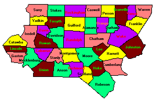
Small North Carolina State Map Piedmont North Carolina County Trip Reports Piedmont North Carolina County Map

Anson Richmond Scotland Robeson Hoke Cumberland Harnett Johnston Lee Chatham Moore Montgomery Stanly Wake Durham Franklin Warren Vance Granville Orange Alamance Person Caswell Guilford Rockingham Forsyth Stokes Surry Yadkin Randolph Davidson Davie Rowan Iredell Catawba Lincoln Cabarrus Gaston Mecklenburg Union

Click on any region from the map above
to access the corresponding reports.
                        Click on any county for highpoint information.

North Carolina main page First Ascent List Disclaimer


    topographic chart (Acme)     aerial photograph (Flash Earth)                     Explanation

topo chart / aerial image scale:     normal     regional overview


Alamance County - Cane Creek Mountains (970+ feet)

        topo chart / aerial image

Anson County - Gordon Mountain (636 feet)

        topo chart / aerial image

Cabarrus County - three areas (890+ feet)

        area 1         area 2         area 3

Caswell County - Stony Creek Mountain (880+ feet)

        topo chart / aerial image

Catawba County - Baker Mountain (1,780 feet)

        topo chart / aerial image

Chatham County - two areas (770+ feet)

        area 1         area 2         area 3

Cumberland County - near Coolyconch Mountain in Fort Bragg (486+ feet)

        topo chart / aerial image

Davidson County - High Rock Mountain (1,188 feet)

        topo chart / aerial image

Davie County - one area (1,010+ feet)

        topo chart / aerial image

Durham County - Red Mountain (770+ feet)

        topo chart / aerial image

Forsyth County - two areas (1,100+ feet)

        area 1         area 2

Franklin County - three unnamed areas (560+ feet)

        area 1         area 2         area 3

Gaston County - The Pinnacle, Kings Mountain (1,690 feet)

        topo chart / aerial image

Granville County - one area (740+ feet) and spot elevation (743 feet)

        area 1         area 2

Guilford County - unnamed point (1,000+ feet)

        topo chart / aerial image

Harnett County - Big Ridge (490+ feet)

        topo chart / aerial image

Hoke County - one area (550+ feet)

        topo chart / aerial image

Iredell County - USGS BM at Fox Mountain (1,740+ feet)

        topo chart / aerial image

Johnston County - two areas (370+ feet)

        area 1         area 2

Lee County - one area (540+ feet)

        topo chart / aerial image

Lincoln County - Buffalo Knob (1,480 feet)

        topo chart / aerial image

Mecklenburg County - one area (890+ feet)

        topo chart / aerial image

Montgomery County - Dark Mountain (953 feet)

        topo chart / aerial image

Moore County - three areas (730+ feet)

        area 1         area 2         area 3

Orange County - Occoneechee Mountain (860+ feet)

        topo chart / aerial image

Person County - unnamed point (890+ feet)

        topo chart / aerial image

Randolph County - Shepard Mountain (1,150+ feet)

        topo chart / aerial image

Richmond County - three areas (620+ feet)

        area 1         area 2         area 3

Robeson County - six areas (240+ feet)

        area 1         area 2         area 3         area 4         area 5         area 6

Rockingham County - fifteen areas (1,040+ feet)

        area 1           area 2           area 3           area 4           area 5
        area 6           area 7           area 8           area 9           area 10
        area 11         area 12         area 13         area 14         area 15

Rowan County - Young's Mountain (1,090+ feet)

        topo chart / aerial image

Scotland County - two areas (480+ feet)

        area 1         area 2

Stanly County - Morrow Mountain (900+ feet)

        topo chart / aerial image

Stokes County - Moore's Knob (2,579 feet)

        topo chart / aerial image

Surry County - Fisher Peak (3,580+ feet)

        topo chart / aerial image

Union County - five areas (780+ feet)

        area 1         area 2         area 3         area 4         area 5

Vance County - three areas (570+ feet)

        area 1         area 2         area 3

Wake County - three unnamed areas (540+ feet)

        area 1         area 2         area 3

Warren County - two unnamed areas (480+ feet)

        area 1         area 2

Yadkin County - USGS BM Click in Brushy Mountains (1,755 feet)

        topo chart / aerial image


Disclaimer

Attempting to reach some of the points listed in this web site can be dangerous, and could lead to accidents resulting in injury or death. Some of the summits lie in rugged and isolated regions, where even minor mishaps can escalate into a life threatening crisis. Other locations lie on private property, military bases, and other areas where access is restricted. Trespassing in these areas can result in being arrested, shot at, or worse. Right of access to these areas is constantly changing, and access in the past does not guarantee present access. By use of this web page, the reader hereby releases the trip report authors, trip report compiler, and webmaster from liability for any injury, including but not limited to monetary loss, death, and other damages that might in any way be connected with this web site.

FAIR WARNING: These are "armchair mountaineer" articles, an offering for amusement, not action. Many of these peaks are potentially life threatening, or are on private property. Adequate mountaineer training and/or owner's permission are required if you choose to pursue this list. The authors cited on this page accept no responsibility for injury, or any liability related to these route descriptions.


State Hyperlinks / Text-only Home Page Introduction Highpoint Superlatives
Highpoint Maps Topographic Prominence Highpointer Celebrities Disclaimer