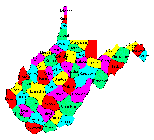
West Virginia State Flag West Virginia County Trip Reports West Virginia County Map

Hancock Brooke Ohio Marshall Wetzel Tyler Monongalia Marion Preston Taylor Pleasants Wood Morgan Berkeley Jefferson Mineral Hampshire Grant Hardy Ritchie Doddridge Harrison Wirt Jackson Mason Cabell Putnam Roane Calhoun Gilmer Lewis Barbour Tucker Upshur Randolph Pendleton Braxton Webster Pocahontas Clay Kanawha Wayne Lincoln Boone Logan Mingo Nicholas Fayette Greenbrier Raleigh Wyoming McDowell Summers Mercer Monroe

USA Map / Home Page                         Click on any county for highpoint information.

All West Virginia county highpoints were first completed by
Mike Schwartz at Doddridge County on December 5, 2001.
Bill Schuler and Bob Packard have since completed as well.
First Ascent List Disclaimer


    topographic chart (Acme)     aerial photograph (Flash Earth)                     Explanation

topo chart / aerial image scale:     normal     regional overview

(coordinates provided by Mike Schwartz)


Barbour County - BM Elliot on Laurel Mountain (3,157 feet) and two points

        BM Elliot         area 2         area 3

Berkeley County - BM Shanghai on Third Hill Mountain (2,172 feet) and three points

        BM Shanghai         area 2         area 3         area 4

Boone County - on county line 1/2 mile SSW of Pilot Knob (3,555- feet)

        topo chart / aerial image

Braxton County - BM Rose (2,183 feet)

        topo chart / aerial image

Brooke County - BM Independence (1,372 feet) and two areas

        BM Independence         area 2         area 3

Cabell County - spot elevation (1,169 feet) and four areas

        spot elevation         area 1         area 2         area 3         area 4

Calhoun County - BM Mule Knob (1,584 feet) and one area

        BM Mule Knob         area 1

Clay County - BM Bird Knob (1,864 feet) and one area

        BM Bird Knob         area 1

Doddridge County - one area WNW of Rinehart (1,660+ feet)

        topo chart / aerial image

Fayette County - Myles Knob (3,460 feet)

        topo chart / aerial image

Gilmer County - BM Longshoal (1,580+ feet)

        topo chart / aerial image

Grant County - near Bell Knob Lookout Tower and on county line (4,140+ feet)

        Bell Knob         area 1

Greenbrier County - Grassy Knob (4,360+ feet)

        topo chart / aerial image

Hampshire County - near Nathaniel Mountain Lookout Tower (3,020 feet)

        topo chart / aerial image

Hancock County - spot elevation (1,363 feet) and five areas

        spot elevation         area 1         area 2         area 3         area 4         area 5

Hardy County - two areas (3,320+ and 3,327 feet)

        area 1         area 2

Harrison County - near BM Charity (1,860+ feet)

        topo chart / aerial image

Jackson County - Garnes Knob (1,225 feet)

        topo chart / aerial image

Jefferson County - spot elevation 4,700 feet SSW of Wilson Gap (1,713 feet)

        topo chart / aerial image

Kanawha County - spot elevation (2,898 feet) and one area

        spot elevation         area 1

Lewis County - area NW of Cleveland (1,960+ feet)

        topo chart / aerial image

Lincoln County - spot elevation (1,686 feet)

        topo chart / aerial image

Logan County - on county line 3,000 feet NW of Burning Rock (2,920+ feet)

        topo chart / aerial image

McDowell County - two areas on Flat Top Mountain (3,400+ feet)

        area 1         area 2

Marion County - spot elevation (2,002 feet)

        topo chart / aerial image

Marshall County - spot elevation near Tunnel Hill (1,602 feet)

        topo chart / aerial image

Mason County - on county line (1,120+/- feet) and one area

        county line         area 1

Mercer County - Buckhorn Knob (4,069 feet)

        topo chart / aerial image

Mineral County - Black Rock (3,160+ feet)

        topo chart / aerial image

Mingo County - Horsepen Mountain (2,524 feet)

        topo chart / aerial image

Monongalia County - on county line (2,560+ feet)

        topo chart / aerial image

Monroe County - spot elevation on Peters Mountain (4,073 feet)

        topo chart / aerial image

Morgan County - area on Cacapon Mountain (2,320+ feet)

        topo chart / aerial image

Nicholas County - two areas near Hanging Rock (3,840+ feet)

        area 1         area 2

Ohio County - four areas (1,420+ feet)

        area 1         area 2         area 3         area 4

Pendleton County - Spruce Knob (4,863 feet and State Highpoint)

        topo chart / aerial image

Pleasants County - one area near Schultz (1,260+ feet) and a second area

        area 1         area 2

Pocahontas County - BM Thorny, Bald Knob, and one area (4,840+ feet)

        BM Thorny         Bald Knob         area 1

Preston County - area on Backbone Mountain (3,400+ feet)

        topo chart / aerial image

Putnam County - spot elevation (1,228 feet)

        topo chart / aerial image

Raleigh County - Ivy Knob (3,600+ feet)

        topo chart / aerial image

Randolph County - Mount Porte Crayon (4,770 feet)

        topo chart / aerial image

Ritchie County - spot elevation (1,435 feet)

        topo chart / aerial image

Roane County - three areas on county line (1,560+ feet)

        area 1         area 2         area 3

Summers County - Keeney Knob (3,927 feet)

        topo chart / aerial image

Taylor County - on county line (2,080- feet)

        topo chart / aerial image

Tucker County - Weiss Knob (4,440+ feet)

        topo chart / aerial image

Tyler County - three areas (1,500+ feet)

        area 1         area 2         area 3

Upshur County - on county line (3,160+ feet)

        topo chart / aerial image

Wayne County - one area (1,560+ feet)

        topo chart / aerial image

Webster County - spot elevation (4,031 feet) and two areas

        spot elevation         area 1         area 2

Wetzel County - one area (1,680+ feet)

        topo chart / aerial image

Wirt County - Ruble Knob (1,320+ feet)

        topo chart / aerial image

Wood County - USGS BM (1,328 feet) and one area

        USGS BM         area 1

Wyoming County - Ivy Knob (3,600+ feet)

        topo chart / aerial image


Disclaimer

Attempting to reach some of the points listed in this web site can be dangerous, and could lead to accidents resulting in injury or death. Some of the summits lie in rugged and isolated regions, where even minor mishaps can escalate into a life threatening crisis. Other locations lie on private property, military bases, and other areas where access is restricted. Trespassing in these areas can result in being arrested, shot at, or worse. Right of access to these areas is constantly changing, and access in the past does not guarantee present access. By use of this web page, the reader hereby releases the trip report authors, trip report compiler, and webmaster from liability for any injury, including but not limited to monetary loss, death, and other damages that might in any way be connected with this web site.

FAIR WARNING: These are "armchair mountaineer" articles, an offering for amusement, not action. Many of these peaks are potentially life threatening, or are on private property. Adequate mountaineer training and/or owner's permission are required if you choose to pursue this list. The authors cited on this page accept no responsibility for injury, or any liability related to these route descriptions.


State Hyperlinks / Text-only Home Page Introduction Highpoint Superlatives
Highpoint Maps Topographic Prominence Highpointer Celebrities Disclaimer