Idaho State Flag Idaho County Trip Reports
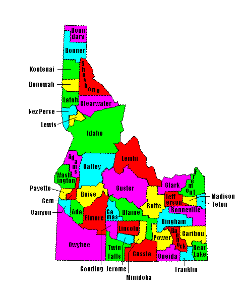
 Idaho County Map

USA Map / Home Page                                                 Click on any county for highpoint information

Of the 44 Idaho counties two share a common highpoint.
Bob Packard and Ken Jones jointed forces on their last Idaho county
to achieve a simultaneous state completion on September 3, 2001
at 10:35 AM MDST (Mountain Daylight Savings Time).
Dan Robbins, Idaho resident, completed in October 2004.

First Ascent List Disclaimer
Bob Bolton's photo album


    topographic chart (Acme)     aerial photograph (Flash Earth)                     Explanation

topo chart / aerial image scale:     normal     regional overview


Ada County - unnamed area (6,000+ feet)

        topo chart / aerial image

Adams County - Monument Peak and spot elevation 4,600 feet south (8,920+ feet)

        Monument Peak         spot elevation

Bannock County - Bonneville Peak (9,271 feet)

        topo chart / aerial image

Bear Lake County - Meade Peak (9,957 feet)

        topo chart / aerial image

Benewah County - unnamed area (6,160+ feet)

        topo chart / aerial image

Bingham County - USGS BM Blackfoot (7,550 feet)

        topo chart / aerial image

Blaine County - Hyndman Peak (12,009 feet)

        topo chart / aerial image

Boise County - Mount Cramer (10,716 feet)

        topo chart / aerial image

Bonner County - Scotchman Peak (7,009 feet)

        topo chart / aerial image

Bonneville County - Mount Baird (10,025 feet)

        topo chart / aerial image

Boundary County - unnamed point (7,709 feet)

        topo chart / aerial image

Butte County - Diamond Peak (12,197 feet)

        topo chart / aerial image

Camas County - 1,200 feet west of 10,337 foot spot elevation (10,360+ feet)

        topo chart / aerial image

Canyon County - Pickles Butte (3,084 feet)

        topo chart / aerial image         photos

Caribou County - Meade Peak (9,957 feet)

        topo chart / aerial image

Cassia County - Cache Peak (10,339 feet)

        topo chart / aerial image

Clark County - two points east of Webber Peak (11,200+ feet)

        area 1         area 2

Clearwater County - Rhodes Peak (7,930 feet)

        topo chart / aerial image

Custer County - Borah Peak (12,662 feet and State Highpoint)

        topo chart / aerial image         photos

Elmore County - Snowyside Peak (10,651 feet)

        topo chart / aerial image

Franklin County - spot elevation (9,484 feet)

        topo chart / aerial image

Fremont County - three points on state line (10,400+ feet)

        area 1         area 2         area 3

Gem County - spot elevation (7,971 feet)

        topo chart / aerial image

Gooding County - on north county line (6,360+ feet)

        topo chart / aerial image

Idaho County - He/She Devil (9,400+ feet) and unnamed point (9,439 feet)

        He Devil         She Devil         point 9439

Jefferson County - spot elevation on Kelly Mountain (6,664 feet)

        topo chart / aerial image

Jerome County - on east county line (ca 4,760 feet)

        topo chart / aerial image

Kootenai County - Latour Peak (6,408 feet)

        topo chart / aerial image

Latah County - Bald Mountain (5,320+ feet)

        topo chart / aerial image

Lemhi County - Bell Mountain (11,612 feet)

        topo chart / aerial image

Lewis County - spot elevation (4,795 feet)

        topo chart / aerial image

Lincoln County - unnamed point (5,950 feet)

        topo chart / aerial image

Madison County - Red Butte (8,108 feet)

        topo chart / aerial image

Minidoka County - Bear Den Butte (5,104 feet)

        topo chart / aerial image

Nez Perce County - unnamed area (5,360+ feet)

        topo chart / aerial image

Oneida County - Oxford Peak (9,282 feet)

        topo chart / aerial image

Owyhee County - Hayden Peak (8,403 feet)

        topo chart / aerial image

Payette County - two unnamed points (4,763 feet)

        area 1         area 2

Power County - Deep Creek Peak (8,748 feet)

        topo chart / aerial image

Shoshone County - Illinois Peak (7,690 feet)

        topo chart / aerial image

Teton County - Garns Mountain (9,016 feet)

        topo chart / aerial image

Twin Falls County - two unnamed points (7,840+ feet)

        area 1         area 2

Valley County - Big Baldy (9,705 feet)

        topo chart / aerial image

Washington County - Cuddy Mountain (7,867 feet)

        topo chart / aerial image


Disclaimer

Attempting to reach some of the points listed in this web site can be dangerous, and could lead to accidents resulting in injury or death. Some of the summits lie in rugged and isolated regions, where even minor mishaps can escalate into a life threatening crisis. Other locations lie on private property, military bases, and other areas where access is restricted. Trespassing in these areas can result in being arrested, shot at, or worse. Right of access to these areas is constantly changing, and access in the past does not guarantee present access. By use of this web page, the reader hereby releases the trip report authors, trip report compiler, and webmaster from liability for any injury, including but not limited to monetary loss, death, and other damages that might in any way be connected with this web site.

FAIR WARNING: These are "armchair mountaineer" articles, an offering for amusement, not action. Many of these peaks are potentially life threatening, or are on private property. Adequate mountaineer training and/or owner's permission are required if you choose to pursue this list. The authors cited on this page accept no responsibility for injury, or any liability related to these route descriptions.


State Hyperlinks / Text-only Home Page Introduction Highpoint Superlatives
Highpoint Maps Topographic Prominence Highpointer Celebrities Disclaimer