|
Oregon County Trip Reports | |
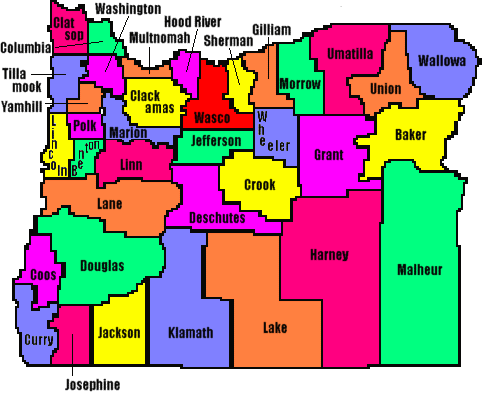
| USA Map / Home Page | Click on any county for highpoint information |
|
Of the 36 counties in Oregon four pairs share common highpoints. All Oregon county highpoints were completed by Ken Jones as of 1999. Bob Packard, Bob Bolton, Bob Schwab, Terry Richard, Dennis Poulin, Mary & Peter Green, and Adam Helman have also completed the Beaver State. |
First Ascent List | Disclaimer |
| Bob Bolton's photo album | Oregon placenames pronunciation |
topo chart / aerial images photos
Benton County - Marys Peak (4,097 feet)topo chart / aerial images photos
Clackamas County - Mount Hood (11,239 feet and State Highpoint)topo chart / aerial images photos
Clatsop County - Saddle Mountain (3,283 feet)topo chart / aerial images photo
Columbia County - Long Mountain (2,265 feet)topo chart / aerial images photos
Crook County - Lookout Mountain (6,926 feet)topo chart / aerial images photos
Douglas County - Mount Thielsen (9,182 feet)topo chart / aerial images photos
Gilliam County - spot elevation (4,285 feet) and one area on south county line (4,280+ feet)topo chart / aerial images photos
Harney County - unnamed peak in Steens Mountain Range (9,733 feet) and unnamed point (9,730 feet)topo chart / aerial images photos
Jackson County - Mount McLoughlin (9,495 feet)topo chart / aerial images photos
Jefferson County - Mount Jefferson (10,497 feet)topo chart / aerial images photos
Josephine County - Grayback Mountain (7,048 feet)topo chart / aerial images photos
Lake County - Crane Mountain (8,456 feet)topo chart / aerial images photos
Lane County - South Sister (10,358 feet)topo chart / aerial images photos
Lincoln County - unnamed area (3,400+ feet) and spot elevation (3,401 feet)topo chart / aerial images photos
Malheur County - BM Stevenson (8,027 feet)topo chart / aerial images photo
Marion County - unnamed point on Mount Jefferson (9,000+ feet)topo chart / aerial images photos
Polk County - Laurel Mountain (3,589 feet)topo chart / aerial images photo
Umatilla County - Tower Mountain (6,850 feet)Sacajawea Peak Matterhorn photos
Wasco County - southwest corner of county (6,280- feet)Saddle Mountain southwest area
Wheeler County - Spanish Peak (6,871 feet)topo chart / aerial images photos
Yamhill County - Trask Mountain (3,424 feet)Disclaimer
Attempting to reach some of the points listed in this web site can be dangerous, and could lead to accidents resulting in injury or death. Some of the summits lie in rugged and isolated regions, where even minor mishaps can escalate into a life threatening crisis. Other locations lie on private property, military bases, and other areas where access is restricted. Trespassing in these areas can result in being arrested, shot at, or worse. Right of access to these areas is constantly changing, and access in the past does not guarantee present access. By use of this web page, the reader hereby releases the trip report authors, trip report compiler, and webmaster from liability for any injury, including but not limited to monetary loss, death, and other damages that might in any way be connected with this web site. FAIR WARNING: These are "armchair mountaineer" articles, an offering for amusement, not action. Many of these peaks are potentially life threatening, or are on private property. Adequate mountaineer training and/or owner's permission are required if you choose to pursue this list. The authors cited on this page accept no responsibility for injury, or any liability related to these route descriptions.| State Hyperlinks / Text-only Home Page | Introduction | Highpoint Superlatives |
| Highpoint Maps | Topographic Prominence | Highpointer Celebrities | Disclaimer |