|
Washington County Trip Reports | |
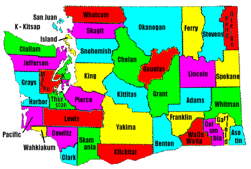
| USA Map / Home Page | Click on any county for highpoint information. |
|
All Washington county highpoints were completed by John Roper as of 1994; followed by Bob Bolton and Bob Packard in 2004; Martin Shetter in 2005; Paul Klenke, Duane Gilliland, and Edward Earl in 2008. |
First Ascent List | Disclaimer |
|
Jeff Howbert's mountain climbing pages - including non-county HP trip reports and peak lists for Washington and Oregon. |
John Roper's mountain climbing pages - including height and prominence-based peak lists plus wonderful photographs. |
|
| Bob Bolton's photo album | Washington placenames pronunciation | |
|
Washington's Fifty Most "Famous" Mountains Steve Fry and Don Beavon's list of noteworthy Washington summits. Microsoft Word version |
topo chart / aerial image photos
Chelan County - Bonanza Peak (9,511 feet)topo chart / aerial image photos
Clallam County - BM Gray Wolf (7,218 feet)area 1 area 2 area 3 area 4 area 5
Jefferson County - Mount Olympus (7,969 feet)topo chart / aerial image photos
King County - Mount Daniel (7,960+ feet)topo chart / aerial image photos
Pacific County - unnamed area (3,000+ feet)topo chart / aerial image photo
Pend Oreille County - Gypsy Peak (7,320+ feet)topo chart / aerial image photos
San Juan County - Mount Constitution (2,407 feet)topo chart / aerial image photos
Skamania County - county line on west slopes of Mount Adams (8,920+ feet)topo chart / aerial image photos
Spokane County - Mount Spokane (5,889 feet)topo chart / aerial image photos
Stevens County - Abercrombie Mountain (7,308 feet)topo chart / aerial image photos
Wahkiakum County - BM Huckleberry (2,673 feet)topo chart / aerial image photos
Whatcom County - Mount Baker (10,781 feet)topo chart / aerial image photos
Whitman County - Tekoa Mountain (4,009 feet)Disclaimer
Attempting to reach some of the points listed in this web site can be dangerous, and could lead to accidents resulting in injury or death. Some of the summits lie in rugged and isolated regions, where even minor mishaps can escalate into a life threatening crisis. Other locations lie on private property, military bases, and other areas where access is restricted. Trespassing in these areas can result in being arrested, shot at, or worse. Right of access to these areas is constantly changing, and access in the past does not guarantee present access. By use of this web page, the reader hereby releases the trip report authors, trip report compiler, and webmaster from liability for any injury, including but not limited to monetary loss, death, and other damages that might in any way be connected with this web site. FAIR WARNING: These are "armchair mountaineer" articles, an offering for amusement, not action. Many of these peaks are potentially life threatening, or are on private property. Adequate mountaineer training and/or owner's permission are required if you choose to pursue this list. The authors cited on this page accept no responsibility for injury, or any liability related to these route descriptions. Consult the Cascade Alpine Guides by Fred Beckey and the Climber's Guide to the Olympic Mountains for detailed information on the "real peaks" listed on this page.| State Hyperlinks / Text-only Home Page | Introduction | Highpoint Superlatives |
| Highpoint Maps | Topographic Prominence | Highpointer Celebrities | Disclaimer |