California State Flag California County Trip Reports
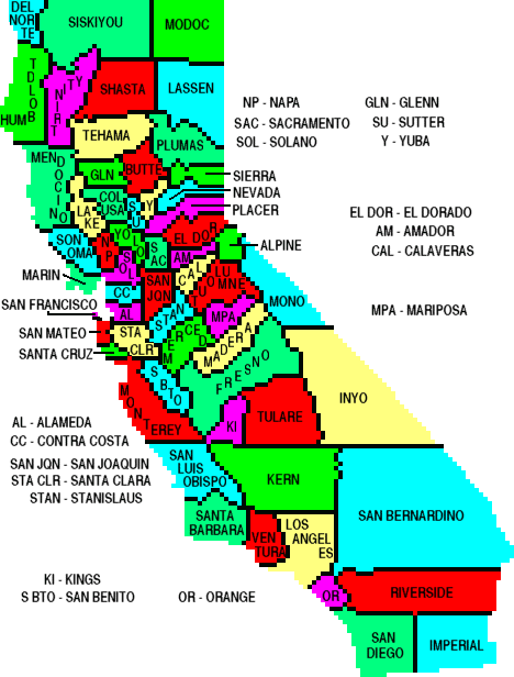
 California County Map

USA Map / Home Page                         Click on any county for highpoint information.

All California county highpoints were completed by
Gary Suttle in 1993. Subsequent completers are Bill Broeckel,
Fred Johnson, Norman Pease, Milton Gaines, John Sarna,
Linda Moulton, Marilyn Mendelson, Pam Heaton, Bill Schuler,
Bill Hartman, Bob Packard, Edward Earl, Adam Helman,
Richard Carey, Gail Hanna, Wit Ashbrook, Ken Jones,
Andy Martin, Bob Burd, Dan Baxter, Dennis Poulin,
and "Dingus Milktoast".
First Ascent List Disclaimer
Dan Baxter's photo album


    topographic chart (Acme)     aerial photograph (Flash Earth)                     Explanation

topo chart / aerial image scale:     normal     regional overview


Alameda County - Discovery Peak (3,840+ feet) and spot elevation 3,841

        Discovery Peak         spot elevation 3,841

Alpine County - Sonora Peak (11,459 feet)

        topo chart / aerial image

Amador County - Thunder Mountain (9,410 feet)

        topo chart / aerial image        

Butte County - Lost Lake Ridge (7,120+ feet)

        topo chart / aerial image

Calaveras County - Corral Ridge (8,170 feet)

        area 1 -         topo chart         aerial image
        area 2 -         topo chart         aerial image
        area 3 -         topo chart         aerial image

        Note: acme.com lacks maps for these highpoints.

        photos

Colusa County - Snow Mountain East (7,040+ feet)

        topo chart / aerial image

Contra Costa County - Mount Diablo (3,849 feet)

  • Report 1 - Andy Martin (June 16, 1998).
  • Report 2 - Peter Maurer (January 15, 2001).
  • Report 3 - Rich Wilson (May 10, 2006).
  • Report 4 - Adam Helman (November 29, 2008). <-- commentary on summit viewshed

        topo chart / aerial image

Del Norte County - Bear Mountain (6,400+ feet)

        topo chart / aerial image

El Dorado County - Freel Peak (10,881 feet)

        topo chart / aerial image

Fresno County - North Palisade (14,242 feet)

          North Palisade: LeConte Route - by Gerry Roach.

        topo chart         aerial image         photos

        Note: acme.com lacks a map for this highpoint.
        The highpoint coordinates are NAD27 (37.0943° N, 118.5135° W).

Glenn County - Black Butte (7,448 feet)

        topo chart / aerial image

Humboldt County - Salmon Mountain (6,956 feet)

        topo chart / aerial image

Imperial County - Blue Angels Peak (4,548 feet)

        topo chart / aerial image        

Inyo County - Mount Whitney (14,494 feet and State Highpoint)

        topo chart / aerial image        

        Caution: acme.com incorrectly places the cursor for this highpoint.
        The highpoint coordinates are NAD27 (36.5786° N, 118.2914° W).

Kern County - Sawmill Mountain (8,818 feet)

  • Report 1 - Walt O'Neil (October 16, 1999).
  • Report 2 - Dave Covill (May 12, 2002).
  • Report 3 - Michael Schwartz (July 3, 2002).
  • Report 4 - Aaron Maizlish (January 29, 2003).
  • Report 5 - Gerry Roach (May 17, 2003).
  • Report 6 - Jon Buyan (August 4, 2003).
  • Report 7 - Layne Bracy (April 13, 2005).
  • Report 8 - Kevin Baker (December 16, 2005).
  • Report 9 - Rich Wilson (May 31, 2006).
  • Report 10 - Ken Oeser (July 23, 2008).

        topo chart / aerial image

        Caution: acme.com incorrectly places the cursor for this highpoint.
        The highpoint coordinates are NAD27 (34.8135° N, 119.1663° W).

Kings County - Table Mountain (3,473 feet)

        No trip reports are posted as per landowner request.

        topo chart / aerial image

Lake County - Snow Mountain East (7,056 feet)

        topo chart / aerial image

Lassen County - Hat Mountain (8,737 feet)

        topo chart / aerial image

Los Angeles County - Mount San Antonio ("Mount Baldy" - 10,064 feet)

        topo chart / aerial image        

Madera County - Mount Ritter (13,143 feet)

        topo chart / aerial image         photo

        Caution: acme.com incorrectly places the cursor for this highpoint.
        The highpoint coordinates are NAD27 (37.6891° N, 119.1986° W).

Marin County - Mount Tamalpais (East Peak - 2,571 feet)

        topo chart / aerial image

Mariposa County - Parsons Peak Ridge (12,040+ feet)

        topo chart / aerial image         photos

        Caution: acme.com incorrectly places the cursor for this highpoint.
        The highpoint coordinates are NAD27 (37.7783° N, 119.3084° W).

Mendocino County - Anthony Peak (6,954 feet)

  • Report 1 - Andy Martin (June 17, 1998).
  • Report 2 - Benjamin Stein (September 6, 2001).
  • Report 3 - Peter Maurer (October 10, 2003).
  • Report 4 - Dean Molen (August 5, 2004).
  • Report 5 - Scott Surgent (July 27, 2005).
  • Report 6 - Ron Tagliapietra (June 27, 2007).

        topo chart / aerial image

Merced County - Laveaga Peak (3,801 feet)

        topo chart / aerial image

Modoc County - Eagle Peak (9,892 feet)

        topo chart / aerial image

Mono County - White Mountain Peak (14,246 feet)

        topo chart / aerial image         photos

        Caution: acme.com incorrectly places the cursor for this highpoint.
        The highpoint coordinates are NAD27 (37.6342° N, 118.2548° W).

Monterey County - Junipero Serra Peak (5,862 feet)

        topo chart / aerial image

Napa County - Mount Saint Helena East (4,200+ feet)

        topo chart / aerial image

Nevada County - Mount Lola (9,148 feet)

        topo chart / aerial image

Orange County - Santiago Peak (5,687 feet)

        topo chart / aerial image        

Placer County - liner on Mount Baldy NW slope (9,040+ feet)

        topo chart / aerial image

Plumas County - Mount Ingalls (8,372 feet)

        topo chart / aerial image

Riverside County - San Jacinto Peak (10,804 feet)

        topo chart / aerial image         photos

Sacramento County - Carpenter Hill (828 feet)

        topo chart / aerial image

San Benito County - San Benito Mountain (5,241 feet)

        topo chart / aerial image

San Bernardino County - San Gorgonio Mountain (11,502 feet)

        topo chart / aerial image        

San Diego County - Hot Springs Mountain (6,533 feet)

        topo chart / aerial image

San Francisco County - Mount Davidson (927 feet)

        topo chart / aerial image

San Joaquin County - Mount Boardman North (3,626 feet)

        topo chart / aerial image

San Luis Obispo County - Caliente Mountain (5,106 feet)

        topo chart / aerial image        

        Caution: acme.com incorrectly places the cursor for this highpoint.
        The highpoint coordinates are NAD27 (35.0364° N, 119.7593° W).

San Mateo County - Long Ridge (2,600+ feet)

          Access to this highpoint is currently restricted.

        topo chart / aerial image

Santa Barbara County - Big Pine Mountain (6,800+ feet)

        topo chart / aerial image        

        Caution: acme.com incorrectly places the cursor for this highpoint.
        The highpoint coordinates are NAD27 (34.6970° N, 119.6528° W).

Santa Clara County - Copernicus Peak (4,360+ feet)

        topo chart / aerial image

Santa Cruz County - Mount McPherson ("Mount Bielawski" - 3,231 feet)

        topo chart / aerial image

Shasta County - Lassen Peak (10,457 feet)

        topo chart / aerial image

Sierra County - Mount Lola North (8,844 feet)

        topo chart / aerial image

Siskiyou County - Mount Shasta (14,162 feet)

        topo chart / aerial image         photos

Solano County - Mount Vaca (2,819 feet)

        topo chart / aerial image

Sonoma County - on Cobb Mountain west slope (4,480+ feet)

        topo chart / aerial image

Stanislaus County - Mount Stakes (3,804 feet)

        topo chart / aerial image

Sutter County - South Butte (2,120+ feet)

        topo chart / aerial image

Tehama County - Brokeoff Mountain (9,235 feet)

        topo chart / aerial image

Trinity County - Mount Eddy (9,025 feet)

        topo chart / aerial image

Tulare County - Mount Whitney (14,494 feet and State Highpoint)

        topo chart / aerial image        

        Caution: acme.com incorrectly places the cursor for this highpoint.
        The highpoint coordinates are NAD27 (36.5786° N, 118.2914° W).

Tuolumne County - Mount Lyell (13,114 feet)

        topo chart / aerial image

        Caution: acme.com incorrectly places the cursor for this highpoint.
        The highpoint coordinates are NAD27 (37.7395° N, 119.2705° W).

Ventura County - Mount Piños (8,831 feet)

        topo chart / aerial image

        Caution: acme.com incorrectly places the cursor for this highpoint.
        The highpoint coordinates are NAD27 (34.8119° N, 119.1465° W).

Yolo County - Little Blue Peak (3,120+ feet)

        topo chart / aerial image

Yuba County - Sugar Pine Peak (4,825+ feet)

        topo chart / aerial image


Disclaimer

Attempting to reach some of the points listed in this web site can be dangerous, and could lead to accidents resulting in injury or death. Some of the summits lie in rugged and isolated regions, where even minor mishaps can escalate into a life threatening crisis. Other locations lie on private property, military bases, and other areas where access is restricted. Trespassing in these areas can result in being arrested, shot at, or worse. Right of access to these areas is constantly changing, and access in the past does not guarantee present access. By use of this web page, the reader hereby releases the trip report authors, trip report compiler, and webmaster from liability for any injury, including but not limited to monetary loss, death, and other damages that might in any way be connected with this web site.

FAIR WARNING: These are "armchair mountaineer" articles, an offering for amusement, not action. Many of these peaks are potentially life threatening, or are on private property. Adequate mountaineer training and/or owner's permission are required if you choose to pursue this list. The authors cited on this page accept no responsibility for injury, or any liability related to these route descriptions.


State Hyperlinks / Text-only Home Page Introduction Highpoint Superlatives
Highpoint Maps Topographic Prominence Highpointer Celebrities Disclaimer