
|
Utah County Trip Reports | |
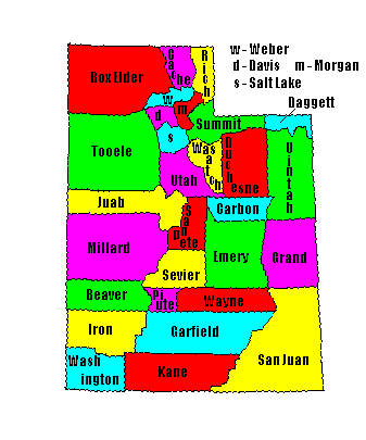
| USA Map / Home Page | Click on any county for highpoint information |
|
Of the 29 counties in Utah 3 pairs share a common high point. All Utah county highpoints were "completed" by Winford 'Dub' Bludworth as of 1992. |
First Ascent List | Disclaimer |
|
Other Utah completers
include Paul Hatch, Ty Hanson, Evan Hanson, Vernon Bonfield, Michael Weibel, Dan Miller, Bob Packard, Andy Martin, Bob Graham, Jobe Wymore, Bob Martin, Val Todd, John Vitz, Scott Casterlin, Edward Earl, Barbara Lilley, Gordon MacLeod, Kline Barney, James and Jessica Wedekind, Rik Dunham, Adam Helman, Jennifer and Gerry Roach, Bill Schuler, Lowell Hurst, Ben and Sherilyn Bennion, Doug Springmeyer, Ben Knorr, Dennis Poulin, Dean Molen, Diane and Charlie Winger, Dale Millsap, Dan Iverson, Bob Schwab, and Ken, Evan, Colin Jones. |
James Wedekind's seven Utah counties in-a-day Trip Report |
topo chart / aerial image photo
Carbon County - Monument Peak (10,452 feet)topo chart / aerial image photo
Grand County - Mount Waas (12,331 feet)topo chart / aerial image photos
Kane County - 10,080+ foot point on Iron County boundarytopo chart / aerial image photos
San Juan County - Mount Peale (12,721 feet)topo chart / aerial image photos
Wasatch County - 10,840 foot point on west side of Murdock MountainDisclaimer
Attempting to reach some of the points listed in this web site can be dangerous, and could lead to accidents resulting in injury or death. Some of the summits lie in rugged and isolated regions, where even minor mishaps can escalate into a life threatening crisis. Other locations lie on private property, military bases, and other areas where access is restricted. Trespassing in these areas can result in being arrested, shot at, or worse. Right of access to these areas is constantly changing, and access in the past does not guarantee present access. By use of this web page, the reader hereby releases the trip report authors, trip report compiler, and webmaster from liability for any injury, including but not limited to monetary loss, death, and other damages that might in any way be connected with this web site. FAIR WARNING: These are "armchair mountaineer" articles, an offering for amusement, not action. Many of these peaks are potentially life threatening, or are on private property. Adequate mountaineer training and/or owner's permission are required if you choose to pursue this list. The authors cited on this page accept no responsibility for injury, or any liability related to these route descriptions.| State Hyperlinks / Text-only Home Page | Introduction | Highpoint Superlatives |
| Highpoint Maps | Topographic Prominence | Highpointer Celebrities | Disclaimer |